Environmental Earth Sciences ( IF 2.8 ) Pub Date : 2024-03-06 , DOI: 10.1007/s12665-024-11455-y Md. Rabiul Islam , H. M. Imran , Md. Rakibul Islam , Ganesh Chandra Saha
|
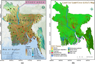
Recognizing soil as a vital resource for food production and animal habitat, this study employed a comprehensive, nationwide erosion assessment in Bangladesh using the Revised Universal Soil Loss Equation (RUSLE) model. Rainfall, soil data, the Digital Elevation Model (DEM), Landsat 8 imagery, and land use and land cover (LULC) maps were employed as inputs for the prediction of potential soil erosion. Utilizing the zonal statistics tool within a geographic information system (GIS) platform, the study area's most erosion-vulnerable zones were subsequently identified and mapped. These zones were designated as 'erosion hotspots' (EHs) with demonstrably clear connections to river basins and networks. Analysis revealed an annual average erosion rate of 1.3 t ha−1 yr−1, resulting in an alarming loss of 17.68 million tons of topsoil annually. Notably, four distinct EHs were identified within the study area. The southeast region, due to its specific topography and climate, was found to be highly susceptible to erosion. Within this region, 2.22% (2995.93 km2) experience erosion exceeding 10.0 t ha−1 yr−1. RUSLE-based results were validated by comparison with outputs from the Global Soil Erosion Modeling Platform (GloSEM) and Google Earth imagery. In addition, the model's performance was evaluated using the receiver operating characteristic (ROC) curve and area under the ROC curve (AUC). The high AUC value of 0.94 achieved in this study reinforces the accuracy and confidence of the soil erosion estimations.
中文翻译:
基于 RUSLE 的综合战略,用于评估孟加拉国沿河国家的土壤侵蚀
本研究认识到土壤是粮食生产和动物栖息地的重要资源,因此利用修订后的通用土壤流失方程 (RUSLE) 模型对孟加拉国进行了全面的全国性侵蚀评估。降雨量、土壤数据、数字高程模型 (DEM)、Landsat 8 图像以及土地利用和土地覆盖 (LULC) 地图被用作预测潜在土壤侵蚀的输入。随后利用地理信息系统(GIS)平台内的分区统计工具,识别并绘制了研究区域最易遭受侵蚀的区域。这些区域被指定为“侵蚀热点”(EH),与河流流域和网络有明显的联系。分析显示,年平均侵蚀率为1.3 t ha -1 yr -1,导致表土每年流失1768万吨,令人震惊。值得注意的是,在研究区域内发现了四个不同的 EH。东南地区由于其特殊的地形和气候,极易遭受侵蚀。在该区域内,2.22%(2995.93 km 2)的侵蚀面积超过10.0 t ha -1 yr -1。通过与全球土壤侵蚀建模平台 (GloSEM) 和 Google 地球图像的输出进行比较,验证了基于 RUSLE 的结果。此外,还使用受试者工作特征(ROC)曲线和ROC曲线下面积(AUC)评估模型的性能。本研究中达到 0.94 的高 AUC 值增强了土壤侵蚀估算的准确性和可信度。


 京公网安备 11010802027423号