当前位置:
X-MOL 学术
›
IET Radar Sonar Navig.
›
论文详情
Our official English website, www.x-mol.net, welcomes your feedback! (Note: you will need to create a separate account there.)
Few-shot learning for satellite characterisation from synthetic inverse synthetic aperture radar images
IET Radar Sonar and Navigation ( IF 1.7 ) Pub Date : 2024-03-07 , DOI: 10.1049/rsn2.12516 Friso G. Heslinga 1 , Faruk Uysal 1 , Sabina B. van Rooij 1 , Sven Berberich 1 , Miguel Caro Cuenca 1
IET Radar Sonar and Navigation ( IF 1.7 ) Pub Date : 2024-03-07 , DOI: 10.1049/rsn2.12516 Friso G. Heslinga 1 , Faruk Uysal 1 , Sabina B. van Rooij 1 , Sven Berberich 1 , Miguel Caro Cuenca 1
Affiliation
|
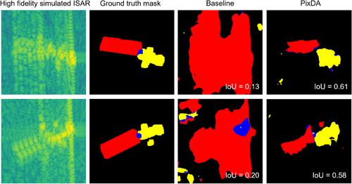
Space situational awareness systems primarily focus on detecting and tracking space objects, providing crucial positional data. However, understanding the complex space domain requires characterising satellites, often involving estimation of bus and solar panel sizes. While inverse synthetic aperture radar allows satellite visualisation, developing deep learning models for substructure segmentation in inverse synthetic aperture radar images is challenging due to the high costs and hardware requirements. The authors present a framework addressing the scarcity of inverse synthetic aperture radar data through synthetic training data. The authors approach utilises a few-shot domain adaptation technique, leveraging thousands of rapidly simulated low-fidelity inverse synthetic aperture radar images and a small set of inverse synthetic aperture radar images from the target domain. The authors validate their framework by simulating a real-case scenario, fine-tuning a deep learning-based segmentation model using four inverse synthetic aperture radar images generated through the backprojection algorithm from simulated raw radar data (simulated at the analogue-to-digital converter level) as the target domain. The authors results demonstrate the effectiveness of the proposed framework, significantly improving inverse synthetic aperture radar image segmentation across diverse domains. This enhancement enables accurate characterisation of satellite bus and solar panel sizes as well as their orientation, even when the images are sourced from different domains.
中文翻译:

从合成逆合成孔径雷达图像中进行卫星表征的少样本学习
空间态势感知系统主要专注于探测和跟踪空间物体,提供关键的位置数据。然而,了解复杂的空间领域需要表征卫星,通常涉及总线和太阳能电池板尺寸的估计。虽然逆合成孔径雷达允许卫星可视化,但由于成本和硬件要求较高,开发用于逆合成孔径雷达图像子结构分割的深度学习模型具有挑战性。作者提出了一个通过合成训练数据解决逆合成孔径雷达数据稀缺问题的框架。作者的方法采用了少镜头域适应技术,利用了数千个快速模拟的低保真度逆合成孔径雷达图像和来自目标域的一小组逆合成孔径雷达图像。作者通过模拟真实场景验证了他们的框架,使用四个逆合成孔径雷达图像微调基于深度学习的分割模型,这些图像是通过模拟原始雷达数据的反投影算法生成的(在模数转换器上模拟) level) 作为目标域。作者的结果证明了所提出框架的有效性,显着改善了跨不同领域的逆合成孔径雷达图像分割。即使图像来自不同的领域,这种增强功能也能够准确表征卫星总线和太阳能电池板的尺寸及其方向。
更新日期:2024-03-07
中文翻译:
从合成逆合成孔径雷达图像中进行卫星表征的少样本学习
空间态势感知系统主要专注于探测和跟踪空间物体,提供关键的位置数据。然而,了解复杂的空间领域需要表征卫星,通常涉及总线和太阳能电池板尺寸的估计。虽然逆合成孔径雷达允许卫星可视化,但由于成本和硬件要求较高,开发用于逆合成孔径雷达图像子结构分割的深度学习模型具有挑战性。作者提出了一个通过合成训练数据解决逆合成孔径雷达数据稀缺问题的框架。作者的方法采用了少镜头域适应技术,利用了数千个快速模拟的低保真度逆合成孔径雷达图像和来自目标域的一小组逆合成孔径雷达图像。作者通过模拟真实场景验证了他们的框架,使用四个逆合成孔径雷达图像微调基于深度学习的分割模型,这些图像是通过模拟原始雷达数据的反投影算法生成的(在模数转换器上模拟) level) 作为目标域。作者的结果证明了所提出框架的有效性,显着改善了跨不同领域的逆合成孔径雷达图像分割。即使图像来自不同的领域,这种增强功能也能够准确表征卫星总线和太阳能电池板的尺寸及其方向。


 京公网安备 11010802027423号