当前位置:
X-MOL 学术
›
Int. J. Appl. Earth Obs. Geoinf.
›
论文详情
Our official English website, www.x-mol.net, welcomes your feedback! (Note: you will need to create a separate account there.)
Using the surface scattering mechanism from dual-pol SAR data to estimate topsoil particle-sizefractions
International Journal of Applied Earth Observation and Geoinformation ( IF 7.5 ) Pub Date : 2024-03-03 , DOI: 10.1016/j.jag.2024.103742 Sandra Cristina Deodoro , Rafael de Andrade Moral , Réamonn Fealy , Tim McCarthy , Rowan Fealy
International Journal of Applied Earth Observation and Geoinformation ( IF 7.5 ) Pub Date : 2024-03-03 , DOI: 10.1016/j.jag.2024.103742 Sandra Cristina Deodoro , Rafael de Andrade Moral , Réamonn Fealy , Tim McCarthy , Rowan Fealy
|
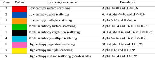
Data extracted from Synthetic Aperture Radar (SAR) have been widely employed to estimate soil properties. However, these studies are typically constrained to bare soil conditions, as soil information retrieval in vegetated areas remains challenging. Polarimetric decomposition has emerged as a potentially useful method to separate the scattering contributions of different targets (e.g. canopy/leaves and the underlying soil), which is of significance for areas that are near-permanently covered in low-lying vegetation (e.g. grass) like Ireland – the study area for this investigation. Here, we test the surface scattering mechanism, derived from H-alpha dual-pol decomposition, together with other covariates, to estimate percentages of sand, silt, and clay, over vegetated terrain, using Sentinel 1 data (dual-pol C-band SAR). The statistical modelling approaches evaluated – linear regression (LRM) and tree-based regression models (machine learning) – explicitly consider the compositional nature of soil texture. When compared to the models fitted without surface scattering data, results showed that the inclusion of the surface scattering data improved estimates of silt and clay, with the compositional linear regression model, and estimates of sand and silt fractions with different tree-based models. While not without limitations, our study demonstrated that the polarimetric decomposition method, which is typically used for classification and segmentation purposes, could also be used for soil property estimation, broadening the application of this technique in microwave remote sensing studies.
中文翻译:

利用双极化 SAR 数据的表面散射机制来估计表土颗粒尺寸分数
从合成孔径雷达(SAR)提取的数据已被广泛用于估计土壤特性。然而,这些研究通常仅限于裸土条件,因为植被地区的土壤信息检索仍然具有挑战性。偏振分解已成为一种潜在有用的方法,可用于分离不同目标(例如树冠/树叶和下面的土壤)的散射贡献,这对于几乎永久被低洼植被(例如草)覆盖的区域具有重要意义爱尔兰——本次调查的研究区域。在这里,我们测试了源自 H-alpha 双极化分解的表面散射机制以及其他协变量,以使用 Sentinel 1 数据(双极化 C 波段)估计植被地形上沙子、淤泥和粘土的百分比特别行政区)。评估的统计建模方法——线性回归(LRM)和基于树的回归模型(机器学习)——明确考虑了土壤质地的组成性质。与没有表面散射数据的模型相比,结果表明,包含表面散射数据可以改进成分线性回归模型对淤泥和粘土的估计,以及使用不同的基于树的模型对沙子和淤泥部分的估计。虽然并非没有限制,但我们的研究表明,通常用于分类和分割目的的极化分解方法也可用于土壤性质估计,拓宽了该技术在微波遥感研究中的应用。
更新日期:2024-03-03
中文翻译:
利用双极化 SAR 数据的表面散射机制来估计表土颗粒尺寸分数
从合成孔径雷达(SAR)提取的数据已被广泛用于估计土壤特性。然而,这些研究通常仅限于裸土条件,因为植被地区的土壤信息检索仍然具有挑战性。偏振分解已成为一种潜在有用的方法,可用于分离不同目标(例如树冠/树叶和下面的土壤)的散射贡献,这对于几乎永久被低洼植被(例如草)覆盖的区域具有重要意义爱尔兰——本次调查的研究区域。在这里,我们测试了源自 H-alpha 双极化分解的表面散射机制以及其他协变量,以使用 Sentinel 1 数据(双极化 C 波段)估计植被地形上沙子、淤泥和粘土的百分比特别行政区)。评估的统计建模方法——线性回归(LRM)和基于树的回归模型(机器学习)——明确考虑了土壤质地的组成性质。与没有表面散射数据的模型相比,结果表明,包含表面散射数据可以改进成分线性回归模型对淤泥和粘土的估计,以及使用不同的基于树的模型对沙子和淤泥部分的估计。虽然并非没有限制,但我们的研究表明,通常用于分类和分割目的的极化分解方法也可用于土壤性质估计,拓宽了该技术在微波遥感研究中的应用。


 京公网安备 11010802027423号