当前位置:
X-MOL 学术
›
Geomorphology
›
论文详情
Our official English website, www.x-mol.net, welcomes your feedback! (Note: you will need to create a separate account there.)
Repeated failures of the giant Beshkiol Landslide and their impact on the long-term Naryn Basin floodings, Kyrgyz Tien Shan
Geomorphology ( IF 3.9 ) Pub Date : 2024-03-06 , DOI: 10.1016/j.geomorph.2024.109121 J. Losen , M. Rizza , A. Nutz , M. Henriquet , M. Schuster , E. Rakhmedinov , S. Baikulov , K. Abdrakhmatov , J. Fleury , L. Siame
Geomorphology ( IF 3.9 ) Pub Date : 2024-03-06 , DOI: 10.1016/j.geomorph.2024.109121 J. Losen , M. Rizza , A. Nutz , M. Henriquet , M. Schuster , E. Rakhmedinov , S. Baikulov , K. Abdrakhmatov , J. Fleury , L. Siame
|
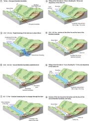
Landslides are major hazards that lead to cataclysmic changes in regional physiography. Their consequences are particularly significant when they affect a river system, forming dammed-lake upstream that represents a high flood threat for the downstream region. The Naryn River is the largest river in the Kyrgyz Tien Shan and is of great economic importance. The Beshkiol Landslide, the largest one in Central Asia but of unknown age, has most likely blocked the Naryn River in the past during the Late Pleistocene, with evidence of thick lacustrine deposits as well as numerous paleo-shorelines preserved upstream. In this study, a detailed geomorphological and sedimentological analysis combined with luminescence and C dating provides a strong chronological framework to refine the dynamics between the Beshkiol landslides and dammed-lakes in the Naryn Basin. We propose that the Beshkiol Landslide was first triggered 51.9 ± 4.4 kyrs ago, with a 410 m-high dam that blocked the Naryn River. A first lake with a total volume of 121 ± 50 km lasted for >37.0 ± 5.1 kyrs, one of the longest landslide-dammed lake residence time ever documented in the world. Our sedimentological observations highlight a catastrophic lake outburst flood between 15.6 and 14.1 kyrs cal BP, likely related to a landslide dam breach. A short-lived phase of fluvial erosion impacted the whole Naryn Basin followed by a second landslide activation (280 m- high dam) and subsequent flooding by a second lake of 27 ± 10 km. This second lake had a minimum residence time of 7.7 ± 1.3 kyrs before its final gradual drainage that was followed by a fluvial erosional phase still active today in the Naryn Basin. We also suggest that the distal unconsolidated part of the Beshkiol Landslide could be remobilized in the event of an earthquake and/or extreme rain episode, causing a potentially dam of the Naryn River, which would have strong regional economic impacts.
中文翻译:

贝什基奥尔巨型滑坡的反复失败及其对吉尔吉斯天山纳伦盆地长期洪水的影响
山体滑坡是导致区域地貌发生灾难性变化的主要灾害。当它们影响河流系统时,其后果尤其严重,在上游形成堰塞湖,对下游地区构成高度的洪水威胁。纳伦河是吉尔吉斯斯坦天山地区最大的河流,具有重要的经济意义。贝什基奥尔山体滑坡是中亚最大的山体滑坡,但年龄未知,它很可能在晚更新世期间堵塞了纳伦河,有证据表明上游有厚厚的湖泊沉积物以及众多古海岸线。在这项研究中,详细的地貌学和沉积学分析与发光和碳测年相结合,提供了一个强大的年代框架,以细化纳伦盆地贝什基奥尔滑坡和堰塞湖之间的动力学。我们推测贝什基奥尔山体滑坡首次引发于 51.9 ± 4.4 kyrs 前,当时一座 410 m 高的大坝堵塞了纳伦河。第一个湖泊总体积为 121 ± 50 公里,持续时间超过 37.0 ± 5.1 kyrs,这是世界上有记录的最长的滑坡堰塞湖停留时间之一。我们的沉积学观测结果强调了 15.6 至 14.1 kyrs cal BP 之间发生的灾难性湖泊溃决洪水,可能与山体滑坡溃坝有关。短暂的河流侵蚀影响了整个纳伦盆地,随后发生了第二次山体滑坡(水坝高 280 米),随后第二个 27 ± 10 公里的湖泊发生洪水。第二个湖泊在最终逐渐排水之前的最短停留时间为 7.7 ± 1.3 kyrs,随后是至今仍在纳伦盆地活跃的河流侵蚀阶段。我们还建议,如果发生地震和/或极端降雨,贝什基奥尔山体滑坡的远端未固结部分可以重新启动,从而可能在纳伦河上筑坝,从而对区域经济产生重大影响。
更新日期:2024-03-06
中文翻译:
贝什基奥尔巨型滑坡的反复失败及其对吉尔吉斯天山纳伦盆地长期洪水的影响
山体滑坡是导致区域地貌发生灾难性变化的主要灾害。当它们影响河流系统时,其后果尤其严重,在上游形成堰塞湖,对下游地区构成高度的洪水威胁。纳伦河是吉尔吉斯斯坦天山地区最大的河流,具有重要的经济意义。贝什基奥尔山体滑坡是中亚最大的山体滑坡,但年龄未知,它很可能在晚更新世期间堵塞了纳伦河,有证据表明上游有厚厚的湖泊沉积物以及众多古海岸线。在这项研究中,详细的地貌学和沉积学分析与发光和碳测年相结合,提供了一个强大的年代框架,以细化纳伦盆地贝什基奥尔滑坡和堰塞湖之间的动力学。我们推测贝什基奥尔山体滑坡首次引发于 51.9 ± 4.4 kyrs 前,当时一座 410 m 高的大坝堵塞了纳伦河。第一个湖泊总体积为 121 ± 50 公里,持续时间超过 37.0 ± 5.1 kyrs,这是世界上有记录的最长的滑坡堰塞湖停留时间之一。我们的沉积学观测结果强调了 15.6 至 14.1 kyrs cal BP 之间发生的灾难性湖泊溃决洪水,可能与山体滑坡溃坝有关。短暂的河流侵蚀影响了整个纳伦盆地,随后发生了第二次山体滑坡(水坝高 280 米),随后第二个 27 ± 10 公里的湖泊发生洪水。第二个湖泊在最终逐渐排水之前的最短停留时间为 7.7 ± 1.3 kyrs,随后是至今仍在纳伦盆地活跃的河流侵蚀阶段。我们还建议,如果发生地震和/或极端降雨,贝什基奥尔山体滑坡的远端未固结部分可以重新启动,从而可能在纳伦河上筑坝,从而对区域经济产生重大影响。


 京公网安备 11010802027423号