当前位置:
X-MOL 学术
›
Remote Sens. Environ.
›
论文详情
Our official English website, www.x-mol.net, welcomes your feedback! (Note: you will need to create a separate account there.)
Detecting early winter open-water zones on Alaska rivers using dual-polarized C-band Sentinel-1 synthetic aperture radar (SAR)
Remote Sensing of Environment ( IF 13.5 ) Pub Date : 2024-03-13 , DOI: 10.1016/j.rse.2024.114096 Melanie Engram , Franz J. Meyer , Dana R.N. Brown , Sarah Clement , Allen C. Bondurant , Katie V. Spellman , Laura E. Oxtoby , Christopher D. Arp
Remote Sensing of Environment ( IF 13.5 ) Pub Date : 2024-03-13 , DOI: 10.1016/j.rse.2024.114096 Melanie Engram , Franz J. Meyer , Dana R.N. Brown , Sarah Clement , Allen C. Bondurant , Katie V. Spellman , Laura E. Oxtoby , Christopher D. Arp
|
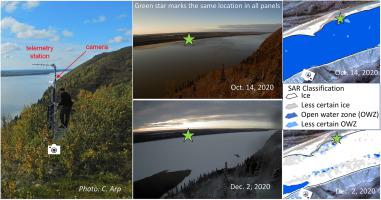
Northern high-latitude river ice provides critical natural infrastructure for winter travel, commerce, hunting, fishing, and recreation in rural areas with little or no road access. Open water zones (OWZs) in river ice are dangerous for such travel and are most common during early winter. Changes in the occurrence and duration of OWZs may also indicate more widespread shifts in ice regimes across Alaska and other northern regions. To aid in detecting open water hazards and broader changes in winter conditions, we developed a supervised classification with a principal component analysis (PCA) using both polarizations of Sentinel-1 C-band synthetic aperture radar (SAR) dual-polarized data for rivers in early winter to discriminate between ice cover and open water. Previous SAR river ice classifications have focused on one or two river reaches often with an emphasis on moving ice during spring break-up, hampering generalization of these results to other rivers and seasons. To address this limitation, we used 12 reaches from eight rivers for training and validation with the aim to combine data from different river types to create an ice classification that could be applied to northern high-latitude rivers from October through January. The classification was trained using shore-based time-lapse photos, aerial photos, and on-ice observations, and validated with shore-based time-lapse photos and independent citizen scientists' photo observations. Overall accuracy for the classification ranged from 65 to 93% with a corresponding range of 0.31–0.84 Cohen's Kappa statistic (). We report some ambiguity between open water and smooth ice, especially in slower-flowing parts of rivers. We conclude that VV and VH thresholds can therefore be customized to increase accuracy, depending on specific river attributes such as river morphology, silt/sediment load, and channel flow velocity. This classification, which allows for mapping long river reaches in low-light winter conditions, can be performed on historical Sentinel-1 imagery to determine areas that display open water year after year. Once customized to a particular river, it can be automated to provide current open water zone maps to Alaskan and other rural northern communities worldwide to aid safer travel on ice.
中文翻译:

使用双偏振 C 波段 Sentinel-1 合成孔径雷达 (SAR) 检测阿拉斯加河流上的初冬开放水域
北部高纬度河冰为道路很少或根本没有道路的农村地区的冬季旅行、商业、狩猎、捕鱼和娱乐提供了重要的自然基础设施。河冰中的开放水域 (OWZ) 对于此类旅行来说是危险的,并且在初冬最常见。 OWZ 的发生和持续时间的变化也可能表明阿拉斯加和其他北部地区的冰情发生了更广泛的变化。为了帮助检测开放水域灾害和冬季条件的更广泛变化,我们使用 Sentinel-1 C 波段合成孔径雷达 (SAR) 双极化河流数据的主成分分析 (PCA) 开发了监督分类。初冬区分冰盖和开放水域。以前的 SAR 河流冰分类通常侧重于一两个河流河段,重点是春季消融期间的移动冰,这妨碍了将这些结果推广到其他河流和季节。为了解决这一限制,我们使用 8 条河流的 12 个河段进行训练和验证,目的是结合不同河流类型的数据来创建可应用于 10 月至 1 月北部高纬度河流的冰分类。该分类是使用岸基延时照片、航空照片和冰上观察进行训练的,并使用岸基延时照片和独立公民科学家的照片观察进行验证。分类的总体准确度范围为 65% 至 93%,相应范围为 0.31-0.84 Cohen 的 Kappa 统计量 ()。我们报告了开放水域和光滑冰之间的一些模糊之处,特别是在河流流速较慢的部分。因此,我们得出的结论是,可以根据特定的河流属性(例如河流形态、淤泥/沉积物负荷和河道流速)定制 VV 和 VH 阈值以提高准确性。这种分类允许在弱光冬季条件下绘制长河段地图,可以在历史 Sentinel-1 图像上执行,以确定年复一年显示开放水域的区域。一旦针对特定河流进行定制,它就可以自动向阿拉斯加和世界各地其他北部农村社区提供当前的开放水域地图,以帮助更安全的冰上旅行。
更新日期:2024-03-13
中文翻译:
使用双偏振 C 波段 Sentinel-1 合成孔径雷达 (SAR) 检测阿拉斯加河流上的初冬开放水域
北部高纬度河冰为道路很少或根本没有道路的农村地区的冬季旅行、商业、狩猎、捕鱼和娱乐提供了重要的自然基础设施。河冰中的开放水域 (OWZ) 对于此类旅行来说是危险的,并且在初冬最常见。 OWZ 的发生和持续时间的变化也可能表明阿拉斯加和其他北部地区的冰情发生了更广泛的变化。为了帮助检测开放水域灾害和冬季条件的更广泛变化,我们使用 Sentinel-1 C 波段合成孔径雷达 (SAR) 双极化河流数据的主成分分析 (PCA) 开发了监督分类。初冬区分冰盖和开放水域。以前的 SAR 河流冰分类通常侧重于一两个河流河段,重点是春季消融期间的移动冰,这妨碍了将这些结果推广到其他河流和季节。为了解决这一限制,我们使用 8 条河流的 12 个河段进行训练和验证,目的是结合不同河流类型的数据来创建可应用于 10 月至 1 月北部高纬度河流的冰分类。该分类是使用岸基延时照片、航空照片和冰上观察进行训练的,并使用岸基延时照片和独立公民科学家的照片观察进行验证。分类的总体准确度范围为 65% 至 93%,相应范围为 0.31-0.84 Cohen 的 Kappa 统计量 ()。我们报告了开放水域和光滑冰之间的一些模糊之处,特别是在河流流速较慢的部分。因此,我们得出的结论是,可以根据特定的河流属性(例如河流形态、淤泥/沉积物负荷和河道流速)定制 VV 和 VH 阈值以提高准确性。这种分类允许在弱光冬季条件下绘制长河段地图,可以在历史 Sentinel-1 图像上执行,以确定年复一年显示开放水域的区域。一旦针对特定河流进行定制,它就可以自动向阿拉斯加和世界各地其他北部农村社区提供当前的开放水域地图,以帮助更安全的冰上旅行。


 京公网安备 11010802027423号