Journal of Agricultural, Biological and Environmental Statistics ( IF 1.4 ) Pub Date : 2024-03-13 , DOI: 10.1007/s13253-024-00611-3 Andrew O. Finley , Hans-Erik Andersen , Chad Babcock , Bruce D. Cook , Douglas C. Morton , Sudipto Banerjee
|
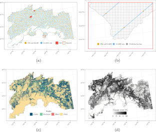
A two-stage hierarchical Bayesian model is developed and implemented to estimate forest biomass density and total given sparsely sampled LiDAR and georeferenced forest inventory plot measurements. The model is motivated by the United States Department of Agriculture (USDA) Forest Service Forest Inventory and Analysis (FIA) objective to provide biomass estimates for the remote Tanana Inventory Unit (TIU) in interior Alaska. The proposed model yields stratum-level biomass estimates for arbitrarily sized areas. Model-based estimates are compared with the TIU FIA design-based post-stratified estimates. Model-based small area estimates (SAEs) for two experimental forests within the TIU are compared with each forest’s design-based estimates generated using a dense network of independent inventory plots. Model parameter estimates and biomass predictions are informed using FIA plot measurements, LiDAR data that are spatially aligned with a subset of the FIA plots, and complete coverage remotely detected data used to define landuse/landcover stratum and percent forest canopy cover. Results support a model-based approach to estimating forest parameters when inventory data are sparse or resources limit collection of enough data to achieve desired accuracy and precision using design-based methods. Supplementary materials accompanying this paper appear on-line
中文翻译:
使用稀疏采样 LiDAR 支持森林清查和小面积估计的模型:涉及阿拉斯加塔纳纳 G-LiHT LiDAR 的案例研究
开发并实施了两阶段分层贝叶斯模型,以根据稀疏采样激光雷达和地理参考森林清查图测量来估计森林生物量密度和总量。该模型的动机是美国农业部 (USDA) 林务局森林清查和分析 (FIA) 目标,为阿拉斯加内陆偏远的塔纳纳清查单位 (TIU) 提供生物量估算。所提出的模型可以对任意大小的区域进行地层生物量估计。将基于模型的估计与基于 TIU FIA 设计的分层后估计进行比较。将 TIU 内两个实验森林基于模型的小面积估计 (SAE) 与使用独立清查地块密集网络生成的每个森林基于设计的估计进行比较。模型参数估计和生物量预测通过 FIA 图测量、与 FIA 图子集在空间上对齐的 LiDAR 数据以及用于定义土地利用/土地覆盖层和森林冠层覆盖百分比的完整覆盖远程检测数据进行通知。当清单数据稀疏或资源限制收集足够的数据以使用基于设计的方法达到所需的准确性和精度时,结果支持基于模型的方法来估计森林参数。本文附带的补充材料出现在网上


 京公网安备 11010802027423号