Environmental Earth Sciences ( IF 2.8 ) Pub Date : 2024-03-16 , DOI: 10.1007/s12665-024-11487-4 Pınar Avcı , Murat Ercanoglu
|
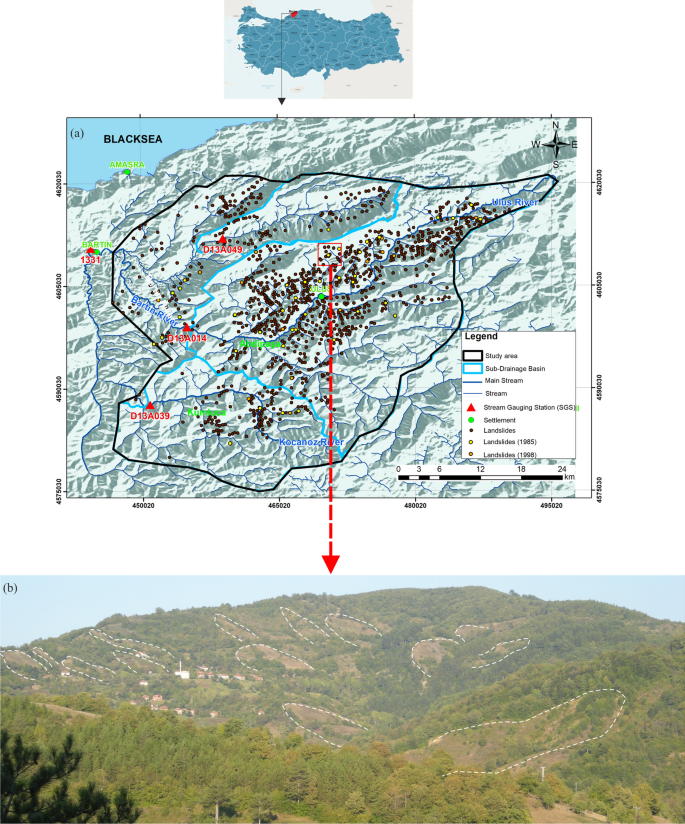
One of the Türkiye’s most destructive natural hazards is landslides. Although much progress has been achieved in this subject throughout the country, there are still some problems related to adequate meteorological and high-quality landslide data. The aim of this study, which was carried out in the eastern part of Bartın province in the Western Black Sea region of Türkiye, is to indirectly determine the possible threshold values for landslides known to be triggered by precipitation. For this purpose, first, data related to landslides, precipitation, and streamflow were compiled and analyzed. Although many landslides have been mapped in the area, it has been determined that the number of reliable data on the dates (only three exact dates) of landslide occurrences is quite limited in the area. The relationship between the landslides that occurred in 1985, 1998, and 2021, and the stream gauging–precipitation data was analyzed. Then, due to the data scarcity related to the precipitation data, an indirect method, called Soil Conservation Service Curve Number (SCS-CN), was used to determine the relation between runoff and precipitation. The results revealed that daily 80 mm and cumulative 160 mm could be selected as the threshold values that may trigger the landslides. This study serves as an illustration of how an indirect approach can be used to approximate potential precipitation thresholds in a data-scarce region. Therefore, it will be possible to use these precipitation thresholds as a basis for future landslide hazard and risk assessments.
中文翻译:
利用水流速率确定数据稀缺地区滑坡的降水阈值(巴尔滕东部、土耳其西北部)
土耳其最具破坏性的自然灾害之一是山体滑坡。尽管全国在这一领域取得了很大进展,但在充足的气象和高质量滑坡数据方面仍然存在一些问题。这项研究在土耳其黑海西部地区的巴尔滕省东部进行,目的是间接确定已知由降水引发的山体滑坡的可能阈值。为此,首先收集并分析了与滑坡、降水和径流相关的数据。尽管该地区已绘制了许多滑坡地图,但已确定该地区有关滑坡发生日期(只有三个确切日期)的可靠数据数量相当有限。分析了 1985 年、1998 年和 2021 年发生的滑坡与测流降水数据之间的关系。然后,由于与降水数据相关的数据稀缺,采用一种称为土壤保持服务曲线数(SCS-CN)的间接方法来确定径流与降水之间的关系。结果表明,可以选择日降雨量80毫米和累计降雨量160毫米作为可能引发滑坡的阈值。这项研究说明了如何使用间接方法来近似数据稀缺地区的潜在降水阈值。因此,可以使用这些降水阈值作为未来滑坡灾害和风险评估的基础。


 京公网安备 11010802027423号