当前位置:
X-MOL 学术
›
Int. J. Appl. Earth Obs. Geoinf.
›
论文详情
Our official English website, www.x-mol.net, welcomes your feedback! (Note: you will need to create a separate account there.)
Long-term series wetland classification of Guangdong-Hong Kong-Macao Greater Bay Area based on APSMnet
International Journal of Applied Earth Observation and Geoinformation ( IF 7.5 ) Pub Date : 2024-03-13 , DOI: 10.1016/j.jag.2024.103765 Anjun Lou , Zhi He , Chengle Zhou , Guanglin Lai
International Journal of Applied Earth Observation and Geoinformation ( IF 7.5 ) Pub Date : 2024-03-13 , DOI: 10.1016/j.jag.2024.103765 Anjun Lou , Zhi He , Chengle Zhou , Guanglin Lai
|
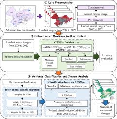
Wetlands play a crucial role in achieving carbon peak and carbon neutrality goals. Exploring spatiotemporal distribution is one of the fundamental task in wetland research. However, existing large-scale and long-term series wetland mapping methods have challenges related to classification accuracy and obtaining inter-annual wetland samples. Therefore, a rapid sample collection and precise classification method are needed to support wetland resource assessment, conservation, and ecological restoration. In this paper, we propose a novel deep learning method suitable for large-scale and long-term series wetland classification. First, we acquire and preprocess the long-term series remote sensing data on the Google Earth Engine (GEE) platform. Second, the maximum wetland extent is extracted using decision trees and the Otsu algorithm (OTSU). Third, the attention and pyramid structure-based multidimensional feature extraction network (APSMnet) and the inter-annual sample migration algorithm (ISM) are proposed for realizing inter-annual wetland classification and wetland change analysis. Experiments conducted on Landsat 7 data of the Guangdong-Hong Kong-Macao Greater Bay Area (GBA) from 2000 to 2022 demonstrate that the overall accuracy (), average accuracy (), and kappa coefficient () achieved by the proposed wetland classification method are 0.9664, 0.9396, and 0.9570, respectively. Long-term series trend analysis reveals that mangrove/swamp areas experience fluctuations influenced by urbanization and ecological policies, ultimately undergoing restoration and becoming stable. The codes and datasets are made available publicly at .
中文翻译:

基于APSMnet的粤港澳大湾区长期系列湿地分类
湿地在实现碳峰值和碳中和目标方面发挥着至关重要的作用。探索时空分布是湿地研究的基础任务之一。然而,现有的大规模和长期系列湿地制图方法在分类精度和获取年际湿地样本方面存在挑战。因此,需要快速的样本采集和精确的分类方法来支持湿地资源评估、保护和生态恢复。在本文中,我们提出了一种适用于大规模和长期系列湿地分类的新型深度学习方法。首先,我们在Google Earth Engine(GEE)平台上获取并预处理长期系列遥感数据。其次,使用决策树和大津算法(OTSU)提取最大湿地范围。第三,提出了基于注意力和金字塔结构的多维特征提取网络(APSMnet)和年际样本迁移算法(ISM)来实现年际湿地分类和湿地变化分析。对2000年至2022年粤港澳大湾区(GBA)Landsat 7数据进行的实验表明,所提出的湿地分类方法的总体精度()、平均精度()和kappa系数()为分别为 0.9664、0.9396 和 0.9570。长期序列趋势分析表明,红树林/沼泽地区受城市化和生态政策的影响经历波动,最终经历恢复并趋于稳定。代码和数据集在 上公开提供。
更新日期:2024-03-13
中文翻译:
基于APSMnet的粤港澳大湾区长期系列湿地分类
湿地在实现碳峰值和碳中和目标方面发挥着至关重要的作用。探索时空分布是湿地研究的基础任务之一。然而,现有的大规模和长期系列湿地制图方法在分类精度和获取年际湿地样本方面存在挑战。因此,需要快速的样本采集和精确的分类方法来支持湿地资源评估、保护和生态恢复。在本文中,我们提出了一种适用于大规模和长期系列湿地分类的新型深度学习方法。首先,我们在Google Earth Engine(GEE)平台上获取并预处理长期系列遥感数据。其次,使用决策树和大津算法(OTSU)提取最大湿地范围。第三,提出了基于注意力和金字塔结构的多维特征提取网络(APSMnet)和年际样本迁移算法(ISM)来实现年际湿地分类和湿地变化分析。对2000年至2022年粤港澳大湾区(GBA)Landsat 7数据进行的实验表明,所提出的湿地分类方法的总体精度()、平均精度()和kappa系数()为分别为 0.9664、0.9396 和 0.9570。长期序列趋势分析表明,红树林/沼泽地区受城市化和生态政策的影响经历波动,最终经历恢复并趋于稳定。代码和数据集在 上公开提供。


 京公网安备 11010802027423号