当前位置:
X-MOL 学术
›
Ecol Modell
›
论文详情
Our official English website, www.x-mol.net, welcomes your feedback! (Note: you will need to create a separate account there.)
The landscape altered the interaction between vegetation and climate in the desert oasis of Hotan River Basin, Xinjiang, China
Ecological Modelling ( IF 3.1 ) Pub Date : 2024-03-13 , DOI: 10.1016/j.ecolmodel.2024.110687 Yimeng Cai , Jiaxin Wu , Tudi Yimiti , Zhouyuan Li , Xiuchun Yang , Shikui Dong
Ecological Modelling ( IF 3.1 ) Pub Date : 2024-03-13 , DOI: 10.1016/j.ecolmodel.2024.110687 Yimeng Cai , Jiaxin Wu , Tudi Yimiti , Zhouyuan Li , Xiuchun Yang , Shikui Dong
|
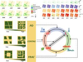
In the arid region, the oasis is characterized by a desert substance and a mosaic of vegetation. The biophysical processes and interactions between vegetation and the local climate in this kind of region are determined by the macroscopic structure of the ecosystems, i.e. landscape patterns. To understand how these landscape patterns impact regional hydro-heat coupling across space and evolve over time, we utilized remote sensing observational data and methods to examine the relationships among these factors. In this case, we focused on the oasis along the upstream of the Hotan River Basin in the Taklamakan Desert in Xinjiang of western China and employed the satellite imagery datasets of Landsat from 1993 to 2019 to investigate the dynamics of vegetation–climate factors. Based on the land use and cover change datasets, the landscape pattern metrics, including patch density (), contagion index (), fractal dimension (), were calculated to measure the landscape features on the different aspects, i.e. the fragmentation, the connectivity, and the complexity. With the algorithm of land surface energy balance, the land surface indicators, including the soil-adjusted vegetation index (I), albedo, surface irradiance temperature (), and evapotranspiration (), were calculated to represent the key process in the interaction of vegetation–climate. The temporal-spatial dynamics of the landscape patterns and the vegetation–climate metrics were mapped and demonstrated in a quantitative manner. The statistical results revealed that during the past decades, the agricultural land in the study area had significantly increased by 17 %. Grassland and shrubs had also expanded, while the desert area decreased from 82.57 % to 78.82 % of the total area, with an overall reduction rate of 1.4 %/10a. It was found the study area was getting warmer and dryer based on the general trends of and observed during the period of 1993–2019. The agricultural land had the highest and , and the lowest . The agricultural land had the lowest and the highest . The results of structural equation model identified the decoupling effects of and on the regional hydro-heat environment, while confirmed that had positive impact on the coupling between and . Our study bridged the landscape pattern with the regional vegetation–climate interaction and provided the suggestions for the landscape planning and management for a more sustainable arid region.
更新日期:2024-03-13


 京公网安备 11010802027423号