当前位置:
X-MOL 学术
›
Environ. Pollut.
›
论文详情
Our official English website, www.x-mol.net, welcomes your feedback! (Note: you will need to create a separate account there.)
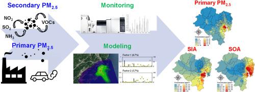
Mapping the spatial distribution of primary and secondary PM2.5 in a multi-industrial city by combining monitoring and modeling results
Environmental Pollution ( IF 8.9 ) Pub Date : 2024-03-16 , DOI: 10.1016/j.envpol.2024.123774 Sang-Jin Lee , Ho-Young Lee , Seong-Joon Kim , Nam-Kyu Kim , Minjae Jo , Chang-Keun Song , Hyoseon Kim , Hyun-Jung Kang , Young-Kyo Seo , Hye-Jung Shin , Sung-Deuk Choi
Environmental Pollution ( IF 8.9 ) Pub Date : 2024-03-16 , DOI: 10.1016/j.envpol.2024.123774 Sang-Jin Lee , Ho-Young Lee , Seong-Joon Kim , Nam-Kyu Kim , Minjae Jo , Chang-Keun Song , Hyoseon Kim , Hyun-Jung Kang , Young-Kyo Seo , Hye-Jung Shin , Sung-Deuk Choi
|
Industrial cities are strongly influenced by primary emissions of PM from local industries. In addition, gaseous precursors, such as sulfur oxides (SO), nitrogen oxides (NO), and volatile organic compounds (VOCs), emitted from industrial sources, undergo conversion into secondary inorganic and organic aerosols (SIAs and SOAs). In this study, the spatial distributions of primary and secondary PM in Ulsan, the largest industrial city in South Korea, were visualized. PM components (ions, carbons, and metals) and PM precursors (SO, NO, NH, and VOCs) were measured to estimate the concentrations of secondary inorganic ions (SO, NO, and NH) and secondary organic aerosol formation potential (SOAFP). The spatial distributions of SIAs and SOAs were then plotted by combining atmospheric dispersion modeling, receptor modeling, and monitoring data. Spatial distribution maps of primary and secondary PM provide fundamental insights for formulating management policies in different districts of Ulsan. For instance, among the five districts in Ulsan, Nam-gu exhibited the highest levels of primary PM and secondary nitrate. Consequently, controlling both PM and NO emissions becomes essential in this district. The methodology developed in this study successfully identified areas with dominant contributions from both primary emissions and secondary formation. This approach can be further applied to prioritize control measures during periods of elevated PM levels in other industrial cities.
中文翻译:

结合监测和建模结果绘制多工业城市一次和二次 PM2.5 的空间分布图
工业城市受到当地工业 PM 一次排放的强烈影响。此外,工业排放的硫氧化物 (SO)、氮氧化物 (NO) 和挥发性有机化合物 (VOC) 等气态前体会转化为二次无机和有机气溶胶(SIA 和 SOA)。在这项研究中,韩国最大的工业城市蔚山的一次和二次 PM 的空间分布被可视化。测量 PM 成分(离子、碳和金属)和 PM 前体(SO、NO、NH 和 VOC),以估算二次无机离子(SO、NO 和 NH)的浓度和二次有机气溶胶形成潜力 (SOAFP) 。然后通过结合大气扩散模型、受体模型和监测数据绘制 SIA 和 SOA 的空间分布。初级和次级PM的空间分布图为制定蔚山不同地区的管理政策提供了基础见解。例如,在蔚山的五个地区中,南区的一次PM和二次硝酸盐含量最高。因此,控制 PM 和 NO 排放在该地区变得至关重要。本研究开发的方法成功地确定了一次排放和二次形成占主导地位的区域。这种方法可以进一步应用于其他工业城市 PM 水平升高期间的优先控制措施。
更新日期:2024-03-16
中文翻译:
结合监测和建模结果绘制多工业城市一次和二次 PM2.5 的空间分布图
工业城市受到当地工业 PM 一次排放的强烈影响。此外,工业排放的硫氧化物 (SO)、氮氧化物 (NO) 和挥发性有机化合物 (VOC) 等气态前体会转化为二次无机和有机气溶胶(SIA 和 SOA)。在这项研究中,韩国最大的工业城市蔚山的一次和二次 PM 的空间分布被可视化。测量 PM 成分(离子、碳和金属)和 PM 前体(SO、NO、NH 和 VOC),以估算二次无机离子(SO、NO 和 NH)的浓度和二次有机气溶胶形成潜力 (SOAFP) 。然后通过结合大气扩散模型、受体模型和监测数据绘制 SIA 和 SOA 的空间分布。初级和次级PM的空间分布图为制定蔚山不同地区的管理政策提供了基础见解。例如,在蔚山的五个地区中,南区的一次PM和二次硝酸盐含量最高。因此,控制 PM 和 NO 排放在该地区变得至关重要。本研究开发的方法成功地确定了一次排放和二次形成占主导地位的区域。这种方法可以进一步应用于其他工业城市 PM 水平升高期间的优先控制措施。


 京公网安备 11010802027423号