当前位置:
X-MOL 学术
›
Int. J. Appl. Earth Obs. Geoinf.
›
论文详情
Our official English website, www.x-mol.net, welcomes your feedback! (Note: you will need to create a separate account there.)
A semi-analytical approach for estimating inland water inherent optical properties and chlorophyll a using airborne hyperspectral imagery
International Journal of Applied Earth Observation and Geoinformation ( IF 7.5 ) Pub Date : 2024-03-22 , DOI: 10.1016/j.jag.2024.103774 Chao Niu , Kun Tan , Xue Wang , Peijun Du , Chen Pan
International Journal of Applied Earth Observation and Geoinformation ( IF 7.5 ) Pub Date : 2024-03-22 , DOI: 10.1016/j.jag.2024.103774 Chao Niu , Kun Tan , Xue Wang , Peijun Du , Chen Pan
|
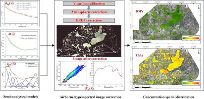
The inversion of inherent optical properties (IOPs) and chlorophyll (Chla) is one of the key objectives in water color remote sensing, and hyperspectral remote sensing with rich spectral information makes precise inversion possible. In this study, we developed a semi-analytical estimation method for inland water IOPs based on the quasi-analytical algorithm (QAA). Considering the complex optical characteristics of inland waters, empirical parameter regional optimization was conducted. Furthermore, a dual-band joint inversion strategy and Gaussian function fitting method were utilized to optimize the solution processes for the backscattering coefficient of particles () and the absorption coefficient of phytoplankton pigments (), respectively. This approach overcomes the limitations of single-band inversion in inland waters. In addition, it directly decomposes the absorption coefficient to obtain using a Gaussian function, which can reduce the intermediate steps and errors caused by indirect inversion. For Chla, we constructed a binary inversion model using (677) and remote sensing reflectance (), where the coefficient of determination (R) exceeded 0.8. We also constructed an airborne hyperspectral image correction process, including vicarious calibration, atmospheric correction, and bidirectional reflectance distribution function (BRDF) correction, obtaining high-precision images. The ground models were successfully applied to the airborne hyperspectral images, mapping the spatial distribution of IOPs and Chla concentration in the study area. The experiments demonstrated that the proposed semi-analytical method using airborne hyperspectral imagery exhibits a good performance in terms of modeling accuracy and mapping analysis, and successfully applied to long-term monitoring using satellite hyperspectral images, highlighting the significant potential of hyperspectral remote sensing for high-precision monitoring of regional water bodies.
中文翻译:

使用机载高光谱图像估算内陆水域固有光学特性和叶绿素 a 的半分析方法
固有光学特性(IOP)和叶绿素(Chla)的反演是水彩遥感的关键目标之一,而具有丰富光谱信息的高光谱遥感使精确反演成为可能。在本研究中,我们开发了一种基于准解析算法(QAA)的内陆水域IOP的半解析估计方法。考虑内陆水域复杂的光学特性,进行经验参数区域优化。此外,采用双波段联合反演策略和高斯函数拟合方法分别优化了颗粒后向散射系数()和浮游植物色素吸收系数()的求解过程。该方法克服了内陆水域单波段反演的局限性。另外,它直接利用高斯函数分解吸收系数来获得,可以减少间接反演带来的中间步骤和误差。对于Chla,我们利用(677)和遥感反射率()构建了二元反演模型,其中决定系数(R)超过0.8。我们还构建了机载高光谱图像校正流程,包括替代标定、大气校正和双向反射分布函数(BRDF)校正,获得高精度图像。地面模型成功应用于机载高光谱图像,绘制了研究区域眼压和叶绿素浓度的空间分布图。实验表明,所提出的机载高光谱图像半解析方法在建模精度和制图分析方面表现出良好的性能,并成功应用于卫星高光谱图像的长期监测,凸显了高光谱遥感在高光谱遥感领域的巨大潜力。 ——区域水体精准监测。
更新日期:2024-03-22
中文翻译:
使用机载高光谱图像估算内陆水域固有光学特性和叶绿素 a 的半分析方法
固有光学特性(IOP)和叶绿素(Chla)的反演是水彩遥感的关键目标之一,而具有丰富光谱信息的高光谱遥感使精确反演成为可能。在本研究中,我们开发了一种基于准解析算法(QAA)的内陆水域IOP的半解析估计方法。考虑内陆水域复杂的光学特性,进行经验参数区域优化。此外,采用双波段联合反演策略和高斯函数拟合方法分别优化了颗粒后向散射系数()和浮游植物色素吸收系数()的求解过程。该方法克服了内陆水域单波段反演的局限性。另外,它直接利用高斯函数分解吸收系数来获得,可以减少间接反演带来的中间步骤和误差。对于Chla,我们利用(677)和遥感反射率()构建了二元反演模型,其中决定系数(R)超过0.8。我们还构建了机载高光谱图像校正流程,包括替代标定、大气校正和双向反射分布函数(BRDF)校正,获得高精度图像。地面模型成功应用于机载高光谱图像,绘制了研究区域眼压和叶绿素浓度的空间分布图。实验表明,所提出的机载高光谱图像半解析方法在建模精度和制图分析方面表现出良好的性能,并成功应用于卫星高光谱图像的长期监测,凸显了高光谱遥感在高光谱遥感领域的巨大潜力。 ——区域水体精准监测。


 京公网安备 11010802027423号