当前位置:
X-MOL 学术
›
Int. J. Appl. Earth Obs. Geoinf.
›
论文详情
Our official English website, www.x-mol.net, welcomes your feedback! (Note: you will need to create a separate account there.)
Detecting and quantifying zero tillage technology adoption in Indian smallholder systems using Sentinel-2 multi-spectral imagery
International Journal of Applied Earth Observation and Geoinformation ( IF 7.5 ) Pub Date : 2024-03-21 , DOI: 10.1016/j.jag.2024.103779 Monish Vijay Deshpande , Dhanyalekshmi Pillai , Vijesh V. Krishna , Meha Jain
International Journal of Applied Earth Observation and Geoinformation ( IF 7.5 ) Pub Date : 2024-03-21 , DOI: 10.1016/j.jag.2024.103779 Monish Vijay Deshpande , Dhanyalekshmi Pillai , Vijesh V. Krishna , Meha Jain
|
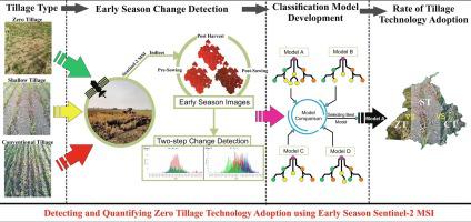
Zero tillage (ZT), an important component of Conservation Agriculture, has enormous potential to curb emissions from residue burning, increase soil organic carbon and water retention, reduce land preparation costs and increase the long-term productivity and profitability of the farming system. Despite the promise of ZT, little is known about how widely it has been adopted at regional scales in smallholder systems, where management is heterogeneous. Identifying ZT diffusion patterns across space and time along with other popular tillage technologies, such as conventional tillage (CT) and shallow tillage (ST), helps to target and disseminate the most effective technologies and estimate their climate change mitigation potential. Acknowledging the complexities involved in distinguishing ZT from CT and ST in smallholder fields, this study utilized an innovative two-step change detection method leveraging early-season Sentinel-2 multi-spectral imagery. We developed and applied our model in the Indian state of Punjab over three years (2020–2022). Our method outperformed traditional binary classification models, achieving 81 % accuracy. The analysis indicated that areas under different tillage types changed over time across Punjab. Specifically, from 2020 to 2021, we found a 33 % and 4 % decrease in ZT and CT, respectively. However, a 29 % increase is observed in CT adoption. On the other hand, from 2021 to 2022, the adoption rates for ZT and CT increased by 18 % and 2 %, respectively, while ST adoption decreased by 12 %. Overall, this study demonstrates the potential use of early season Sentinel-2 imagery to map the adoption of tillage practices in smallholder systems. Our approach can provide large-scale information on technology uptake, aiding policies to implement carbon markets and the scaling up of sustainable agricultural practices in India.
中文翻译:

使用 Sentinel-2 多光谱图像检测和量化印度小农系统中零耕技术的采用情况
零耕(ZT)是保护性农业的重要组成部分,在抑制残留物燃烧排放、增加土壤有机碳和保水性、降低整地成本以及提高耕作系统的长期生产力和盈利能力方面具有巨大潜力。尽管 ZT 前景广阔,但人们对它在管理异构的小农系统中在区域范围内的采用程度知之甚少。识别 ZT 在空间和时间上的扩散模式以及其他流行的耕作技术,例如常规耕作 (CT) 和浅耕 (ST),有助于确定和传播最有效的技术并估计其减缓气候变化的潜力。认识到在小农田中区分 ZT 与 CT 和 ST 的复杂性,本研究采用了一种创新的两步变化检测方法,该方法利用了早季 Sentinel-2 多光谱图像。我们历时三年(2020-2022 年)在印度旁遮普邦开发并应用了我们的模型。我们的方法优于传统的二元分类模型,达到 81% 的准确率。分析表明,旁遮普邦不同耕作类型的面积随着时间的推移而变化。具体来说,从 2020 年到 2021 年,我们发现 ZT 和 CT 分别下降了 33% 和 4%。然而,CT 的采用率增加了 29%。另一方面,从 2021 年到 2022 年,ZT 和 CT 的采用率分别增长了 18% 和 2%,而 ST 的采用率下降了 12%。总体而言,本研究证明了早季 Sentinel-2 图像在绘制小农系统中耕作实践采用情况的潜在用途。我们的方法可以提供有关技术采用的大规模信息,协助实施碳市场的政策以及扩大印度的可持续农业实践。
更新日期:2024-03-21
中文翻译:
使用 Sentinel-2 多光谱图像检测和量化印度小农系统中零耕技术的采用情况
零耕(ZT)是保护性农业的重要组成部分,在抑制残留物燃烧排放、增加土壤有机碳和保水性、降低整地成本以及提高耕作系统的长期生产力和盈利能力方面具有巨大潜力。尽管 ZT 前景广阔,但人们对它在管理异构的小农系统中在区域范围内的采用程度知之甚少。识别 ZT 在空间和时间上的扩散模式以及其他流行的耕作技术,例如常规耕作 (CT) 和浅耕 (ST),有助于确定和传播最有效的技术并估计其减缓气候变化的潜力。认识到在小农田中区分 ZT 与 CT 和 ST 的复杂性,本研究采用了一种创新的两步变化检测方法,该方法利用了早季 Sentinel-2 多光谱图像。我们历时三年(2020-2022 年)在印度旁遮普邦开发并应用了我们的模型。我们的方法优于传统的二元分类模型,达到 81% 的准确率。分析表明,旁遮普邦不同耕作类型的面积随着时间的推移而变化。具体来说,从 2020 年到 2021 年,我们发现 ZT 和 CT 分别下降了 33% 和 4%。然而,CT 的采用率增加了 29%。另一方面,从 2021 年到 2022 年,ZT 和 CT 的采用率分别增长了 18% 和 2%,而 ST 的采用率下降了 12%。总体而言,本研究证明了早季 Sentinel-2 图像在绘制小农系统中耕作实践采用情况的潜在用途。我们的方法可以提供有关技术采用的大规模信息,协助实施碳市场的政策以及扩大印度的可持续农业实践。


 京公网安备 11010802027423号