当前位置:
X-MOL 学术
›
Ecol. Indic.
›
论文详情
Our official English website, www.x-mol.net, welcomes your feedback! (Note: you will need to create a separate account there.)
High-resolution remotely sensed data characterizes indices of avifaunal habitat on private residential lands in a global metropolis
Ecological Indicators ( IF 6.9 ) Pub Date : 2024-03-22 , DOI: 10.1016/j.ecolind.2024.111900 Christian Benitez , Michael Beland , Sevan Esaian , Eric M. Wood
Ecological Indicators ( IF 6.9 ) Pub Date : 2024-03-22 , DOI: 10.1016/j.ecolind.2024.111900 Christian Benitez , Michael Beland , Sevan Esaian , Eric M. Wood
|
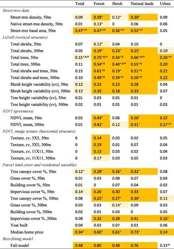
Urban ecosystems are dominated by private lands which poses a significant hurdle to performing field-based assessment of wildlife. An alternative approach is to characterize indices of animal habitat in difficult-to-access areas using data from airborne remote sensing platforms. Characterizing indices of wildlife habitat using remotely sensed data is common in natural systems but has received less attention within urban ecosystems. We tested the utility of using remotely sensed data from high-resolution airborne sensors, including LiDAR, a measure of vertical habitat structure, NDVI, a measure of greenness, image texture, a measure of horizontal habitat structure, and parcel level land-cover data, along with field-based street-tree measurements to predict bird abundance and richness across Greater Los Angeles, California, USA. We surveyed birds and gathered street-tree data on public lands of residential neighborhoods and processed the remote sensing data in 50-m and 300-m circular buffers of bird survey locations to capture data primarily on private, residential land across three winter field seasons (2016–18, 2019/20) at 23 locations along a tree-canopy cover gradient. Data from LiDAR processed as an index for the density of trees summarized in the 50-m and 300-m extents were the strongest univariate predictors of avifaunal abundance and richness explaining 75 % and 74 % of the likelihood in fitted models. NDVI, image texture, land cover, and street-tree density measures were weaker univariate predictors than models fitted with LiDAR data. Models including LiDAR and ground-based street-tree measurements accounted for upwards of 80 % of the variability in avifaunal abundance and richness, particularly for bird species associated with trees and shrubs. We recommend the prioritization of high-resolution remote sensing data, particularly LiDAR, in combination with field-based habitat measures e.g., street trees, to characterize indices of avifaunal habitat on public and private lands of cities, which could help to improve our understanding of the distribution of birds across urban areas.
中文翻译:

高分辨率遥感数据描述了全球大都市私人住宅土地上鸟类动物栖息地的指数
城市生态系统以私人土地为主,这对对野生动物进行实地评估构成了重大障碍。另一种方法是利用机载遥感平台的数据来表征难以进入地区的动物栖息地指数。使用遥感数据表征野生动物栖息地指数在自然系统中很常见,但在城市生态系统中受到的关注较少。我们测试了使用来自高分辨率机载传感器的遥感数据的实用性,包括 LiDAR(垂直栖息地结构的测量)、NDVI(绿化度的测量)、图像纹理、水平栖息地结构的测量以及地块级土地覆盖数据以及基于实地的行道树测量,以预测美国加利福尼亚州大洛杉矶地区的鸟类丰度和丰富度。我们调查了鸟类并收集了住宅区公共土地上的街道树木数据,并在鸟类调查地点的 50 米和 300 米圆形缓冲区中处理了遥感数据,以捕获主要在三个冬季野外季节的私人住宅土地上的数据( 2016-18、2019/20)在沿树冠覆盖梯度的 23 个位置。来自 LiDAR 的数据被处理为 50 米和 300 米范围内的树木密度指数,是鸟类动物丰度和丰富度的最强单变量预测因子,解释了拟合模型中 75% 和 74% 的可能性。 NDVI、图像纹理、土地覆盖和街道树木密度测量的单变量预测因子比拟合 LiDAR 数据的模型更弱。包括激光雷达和地面行道树测量在内的模型解释了鸟类动物丰度和丰富度变异性的 80% 以上,特别是与树木和灌木相关的鸟类物种。我们建议优先考虑高分辨率遥感数据,特别是激光雷达,与基于实地的栖息地测量(例如行道树)相结合,以表征城市公共和私人土地上的鸟类动物栖息地指数,这有助于提高我们对鸟类在城市地区的分布。
更新日期:2024-03-22
中文翻译:
高分辨率遥感数据描述了全球大都市私人住宅土地上鸟类动物栖息地的指数
城市生态系统以私人土地为主,这对对野生动物进行实地评估构成了重大障碍。另一种方法是利用机载遥感平台的数据来表征难以进入地区的动物栖息地指数。使用遥感数据表征野生动物栖息地指数在自然系统中很常见,但在城市生态系统中受到的关注较少。我们测试了使用来自高分辨率机载传感器的遥感数据的实用性,包括 LiDAR(垂直栖息地结构的测量)、NDVI(绿化度的测量)、图像纹理、水平栖息地结构的测量以及地块级土地覆盖数据以及基于实地的行道树测量,以预测美国加利福尼亚州大洛杉矶地区的鸟类丰度和丰富度。我们调查了鸟类并收集了住宅区公共土地上的街道树木数据,并在鸟类调查地点的 50 米和 300 米圆形缓冲区中处理了遥感数据,以捕获主要在三个冬季野外季节的私人住宅土地上的数据( 2016-18、2019/20)在沿树冠覆盖梯度的 23 个位置。来自 LiDAR 的数据被处理为 50 米和 300 米范围内的树木密度指数,是鸟类动物丰度和丰富度的最强单变量预测因子,解释了拟合模型中 75% 和 74% 的可能性。 NDVI、图像纹理、土地覆盖和街道树木密度测量的单变量预测因子比拟合 LiDAR 数据的模型更弱。包括激光雷达和地面行道树测量在内的模型解释了鸟类动物丰度和丰富度变异性的 80% 以上,特别是与树木和灌木相关的鸟类物种。我们建议优先考虑高分辨率遥感数据,特别是激光雷达,与基于实地的栖息地测量(例如行道树)相结合,以表征城市公共和私人土地上的鸟类动物栖息地指数,这有助于提高我们对鸟类在城市地区的分布。


 京公网安备 11010802027423号