当前位置:
X-MOL 学术
›
Ecol. Indic.
›
论文详情
Our official English website, www.x-mol.net, welcomes your feedback! (Note: you will need to create a separate account there.)
Linking wilderness mapping and ecosystem services: Identifying integrated wilderness and ecological indicators to quantify ecosystem services of wilderness
Ecological Indicators ( IF 6.9 ) Pub Date : 2024-03-25 , DOI: 10.1016/j.ecolind.2024.111915 Ruirui Zhu , Weiyi Liu , Ruixin Xue , Shuo Teng , Yefan Wang , Yanting Pan , Weijun Gao
Ecological Indicators ( IF 6.9 ) Pub Date : 2024-03-25 , DOI: 10.1016/j.ecolind.2024.111915 Ruirui Zhu , Weiyi Liu , Ruixin Xue , Shuo Teng , Yefan Wang , Yanting Pan , Weijun Gao
|
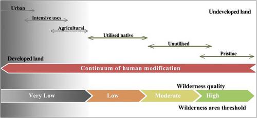
Wilderness has proven to provide a wide range of ecosystem services (ES). Wilderness have been shown to play an important role in preserving biodiversity and providing ES, which is indispensable to both nature and people. It is essential to integrate ES quantification into wilderness conservation and management. This study presents a method that combines the wilderness mapping and ecological indicators to measure ES of wilderness. The method was applied in 155,800 km of Shandong province in China, across 23 types of land use. First, relative wilderness value (RWV) and ecosystem service capability (ESC) were quantified according to Weighted Linear Combination (WLC). Then, spatial autocorrelation between RWV and ESC were tested and analyzed using GeoDa software. Finally, the Redundancy analysis was used to investigate the primary drivers of RWV and ESC in different landscape types. The findings showed that, there were 27,263 km of wilderness in Shandong province, of which 6,294 km were high-quality wilderness. The region with the highest RWV was the Yellow River Delta (RWV = 0.82), and the area with the highest ESC was Laoshan Mountain (ESC = 0.76). Spatial autocorrelation analysis showed a positive correlation between RWV and ESC (Pearson’s r = 0.637), both of which had significant spatial relevance (Moran’s I = 0.589, P < 0.005). The RWV and ESC high-high clusters were found to cover 5,223 km of high-quality wilderness areas. Regression analysis (R = 0.744) showed that RWV can quantify ESC of urban area reliably. Population density (Explaining 33.9 %-49.3 %) was found to be a key indicator of RWV and ESC changes through the Redundancy analysis. In addition, we discussed key drivers of RWV and ESC of high-quality wilderness according to different landscape types. This approach can be used and adopted to support planning decisions dealing with wilderness conservation and management.
更新日期:2024-03-25


 京公网安备 11010802027423号