当前位置:
X-MOL 学术
›
Remote Sens. Environ.
›
论文详情
Our official English website, www.x-mol.net, welcomes your feedback! (Note: you will need to create a separate account there.)
Mapping proglacial headwater streams in High Mountain Asia using PlanetScope imagery
Remote Sensing of Environment ( IF 13.5 ) Pub Date : 2024-03-22 , DOI: 10.1016/j.rse.2024.114124 Jonathan A. Flores , Colin J. Gleason , Craig B. Brinkerhoff , Merritt E. Harlan , M. Malisse Lummus , Leigh A. Stearns , Dongmei Feng
Remote Sensing of Environment ( IF 13.5 ) Pub Date : 2024-03-22 , DOI: 10.1016/j.rse.2024.114124 Jonathan A. Flores , Colin J. Gleason , Craig B. Brinkerhoff , Merritt E. Harlan , M. Malisse Lummus , Leigh A. Stearns , Dongmei Feng
|
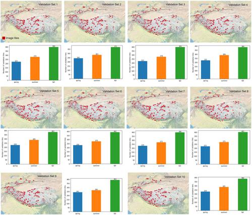
Headwater streams transport nutrients, sediment, and mineral-rich groundwater downstream. In High Mountain Asia (HMA), headwater streams also funnel glacier and snow melt to sustain continuous water supply for the downstream region. These channels remain poorly mapped because of their inaccessibility and because they are smaller than the resolution of Landsat (30 m) and Sentinel-2 (10 m). In this study, we assessed the ability of 3 m resolution PlanetScope imagery to detect the proglacial headwaters downstream of all high-altitude glaciers larger than 5 km in HMA. We created 3000 manually labeled image tiles to train and evaluate computer vision (CV) against techniques common in the hydrologic remote sensing literature, specifically normalized difference water index (NDWI) thresholding and random forests (RF). Results indicate that CV best detects the headwater streams with >0.60 F1-scores, nearly 0.20 points higher than RF and 0.45 points higher than thresholding. We also assessed how errors in CV propagate to derived hydrologic information, exemplified by the biogeochemically critical measurement of stream surface area. We found that CV classifications produced surface areas with 0.98 R, 0.01 km MAE, and 0.02 km RMSE against manually labeled surface areas. We also observed the best CV performance during the spring season with 30% more skillful classification performance than in summer and fall. Our results prove the ability of PlanetScope imagery to detect and map headwater streams accurately and at scale, and that classification errors stemming from the imagery or the CV methods do not greatly impair our ability to quantify stream surface area meaningful for biogeochemical exchange and hydrology studies.
中文翻译:

使用 PlanetScope 图像绘制亚洲高山冰川前源流图
源头溪流将营养物、沉积物和富含矿物质的地下水输送到下游。在亚洲高山 (HMA),源头溪流还汇集了冰川和融雪,以维持下游地区的持续供水。由于无法访问且小于 Landsat (30 m) 和 Sentinel-2 (10 m) 的分辨率,这些通道的地图绘制仍然很差。在这项研究中,我们评估了 3 m 分辨率的 PlanetScope 图像检测 HMA 中所有大于 5 km 的高海拔冰川下游前冰川源头的能力。我们创建了 3000 个手动标记的图像图块,以根据水文遥感文献中常见的技术(特别是归一化差异水指数 (NDWI) 阈值和随机森林 (RF))来训练和评估计算机视觉 (CV)。结果表明,CV 能够最好地检测 F1 分数 >0.60 的源头河流,比 RF 高出近 0.20 个点,比阈值高出 0.45 个点。我们还评估了 CV 中的误差如何传播到派生的水文信息,例如河流表面积的生物地球化学临界测量。我们发现,与手动标记的表面积相比,CV 分类产生的表面积为 0.98 R、0.01 km MAE 和 0.02 km RMSE。我们还观察到春季的 CV 性能最佳,其熟练的分类性能比夏季和秋季高出 30%。我们的结果证明了 PlanetScope 图像能够准确、大规模地检测和绘制源头河流的能力,并且图像或 CV 方法产生的分类错误不会极大地削弱我们量化对生物地球化学交换和水文研究有意义的河流表面积的能力。
更新日期:2024-03-22
中文翻译:
使用 PlanetScope 图像绘制亚洲高山冰川前源流图
源头溪流将营养物、沉积物和富含矿物质的地下水输送到下游。在亚洲高山 (HMA),源头溪流还汇集了冰川和融雪,以维持下游地区的持续供水。由于无法访问且小于 Landsat (30 m) 和 Sentinel-2 (10 m) 的分辨率,这些通道的地图绘制仍然很差。在这项研究中,我们评估了 3 m 分辨率的 PlanetScope 图像检测 HMA 中所有大于 5 km 的高海拔冰川下游前冰川源头的能力。我们创建了 3000 个手动标记的图像图块,以根据水文遥感文献中常见的技术(特别是归一化差异水指数 (NDWI) 阈值和随机森林 (RF))来训练和评估计算机视觉 (CV)。结果表明,CV 能够最好地检测 F1 分数 >0.60 的源头河流,比 RF 高出近 0.20 个点,比阈值高出 0.45 个点。我们还评估了 CV 中的误差如何传播到派生的水文信息,例如河流表面积的生物地球化学临界测量。我们发现,与手动标记的表面积相比,CV 分类产生的表面积为 0.98 R、0.01 km MAE 和 0.02 km RMSE。我们还观察到春季的 CV 性能最佳,其熟练的分类性能比夏季和秋季高出 30%。我们的结果证明了 PlanetScope 图像能够准确、大规模地检测和绘制源头河流的能力,并且图像或 CV 方法产生的分类错误不会极大地削弱我们量化对生物地球化学交换和水文研究有意义的河流表面积的能力。


 京公网安备 11010802027423号