Acta Geophysica ( IF 2.3 ) Pub Date : 2024-04-08 , DOI: 10.1007/s11600-024-01341-3 Ibrahim Shaik , Mohammed Suhail , Pullaiahgari Venkata Nagamani
|
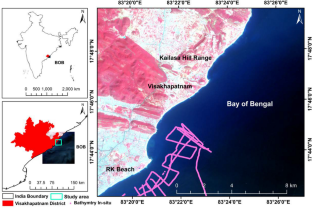
Coastal morphology is persistently changing in structure and environment because of natural and anthropogenic effects. Consequently, determining the spatiotemporal variability of coastal areas has become a significant source of concern. The study focuses on automatic delineation of the shoreline using edge detection algorithms; quantification of the morphological changes using a digital shoreline analysis system (DSAS); and retrieval of coastal bathymetry using linear wave dispersion relation from optical imagery for the period 2005–2020. The Canny algorithm shows efficiency in detecting shoreline precisely (95.6%). The highest erosions for net shoreline movement (NSM) are −31.71 m and −50.43 m/yr for end point rate (EPR) during 2014–2017, whereas the maximum accretions for NSM are 25.37 m and 8.64 m/yr for EPR during 2011–2014. The linear regression rate (LRR) and weighted linear regression (WLR) measure shoreline shift over a 15-year period, with the maximum rates of accretion and erosion being 1.01 m/yr and −1.02 m/yr, respectively. Shoreline prediction was carried out using the Kalman filter model for the year 2021 and was concurrently validated with field DGPS measurements. The retrieved bathymetry over the study area agrees with in situ bathymetry data with a mean bias error (MBE) of 0.39, a correlation coefficient (r) of 0.821, and a coefficient of determination (R2) of 0.742. The study also illustrates the effects of changes in mean sea level (MSL) height and coastal bathymetry on coastal morphology. Coastal bathymetry shows an inverse relationship (r = −0.765) with NSM, whereas MSL height shows a positive relationship with NSM (r = 0.403).
中文翻译:
使用高分辨率光学图像对印度维沙卡帕特南海岸的海平面上升和海岸测深进行海岸线划定和变化分析
由于自然和人为影响,海岸形态的结构和环境不断变化。因此,确定沿海地区的时空变化已成为一个重要的关注点。该研究的重点是使用边缘检测算法自动描绘海岸线;使用数字海岸线分析系统(DSAS)量化形态变化;以及利用 2005-2020 年期间光学图像的线性波色散关系检索海岸测深。 Canny 算法显示了精确检测海岸线的效率 (95.6%)。 2014-2017年间,净海岸线移动(NSM)的最高侵蚀量为-31.71 m,端点率(EPR)为-50.43 m/年,而2011年期间,NSM的最大侵蚀量为25.37 m,EPR的最大增加量为8.64 m/年。 –2014 年。线性回归率 (LRR) 和加权线性回归 (WLR) 测量 15 年期间的海岸线移动,最大吸积率和侵蚀率分别为 1.01 m/年和 -1.02 m/年。 2021 年海岸线预测是使用卡尔曼滤波器模型进行的,并同时与现场 DGPS 测量进行了验证。研究区反演的测深数据与原位测深数据一致,平均偏差误差(MBE)为0.39,相关系数(r)为0.821,决定系数(R 2)为0.742。该研究还说明了平均海平面(MSL)高度和海岸测深变化对海岸形态的影响。海岸测深显示与 NSM 呈反比关系 ( r = -0.765),而 MSL 高度与 NSM 呈正相关 ( r = 0.403)。


 京公网安备 11010802027423号