Acta Geodaetica et Geophysica ( IF 1.4 ) Pub Date : 2024-04-10 , DOI: 10.1007/s40328-024-00437-y Ahmed Hamed , Raafat El-Shafie Fat-Helbary , Abdel-Monem Mohamed , Karrar Omar El-Faragawy , Ahmed Abd El Gaber , Ahmed M. Meneisy
|
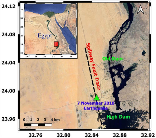
An earthquake of local magnitude ML = 4.6 occurred on November 7, 2010, 4.5 km northwest of the Aswan High Dam on the Spillway Fault. In the Aswan metropolitan region this earthquake was felt intensely. As no surface rupture was found, the focal mechanism and the distribution of seismic activity was one of the tools used for finding fault dimensions. The composite fault-plane solutions for the observed events on the Spillway Fault showed a left lateral strike-slip faulting with normal-fault component striking NNW-SSE. Also, remote sensing techniques were applied for the detection and identification of the geomorphology and geometry of the Spillway Fault. In this research, sub-surface layers and structures are delineated utilizing near-surface seismic techniques. Furthermore, the area’s supposed path and position of the Spillway Fault are also investigated. Two active seismic techniques, Seismic Refraction and Multi-Channel Analysis of Surface Waves (MASW), are utilized for recording near-surface seismic wave data at 9 sites. The seismic refraction profiles are conducted as a 2D cross-section on the trace of the detected Spillway Fault in the study area to evaluate the maximum depth of penetration of the P-wave for fault investigation. The constructed 2D seismic and structural sections from P-wave results show that the obtained average depth of about 30 m. In addition, the estimated P-wave velocities extend from 600 m/s to over 6500 m/s. Some lateral variation in the seismic wave velocities in all layers may represent fault zones. Moreover, the 1D MASW technique is conducted to estimate the velocities of the shear wave for the upper 30 m (Vs30) to provide the site classes and soil characteristics along both sides of the detected Spillway Fault trace in the study area. The calculated Vs30 values emphasized the idea of the existence of a normal dip-slip fault trace which divides the study area into two different lithological parts. The first part is located on the eastern side and characterized by almost class B (hard rock, according to NEHRP classification), while the other part is located to the west, and shows almost class type C (denoted as dense soil and soft rock soil).
中文翻译:
应用地震折射和 MASW 方法调查埃及阿斯旺高坝西侧的溢洪道断层迹
2010 年 11 月 7 日,在溢洪断层阿斯旺高坝西北 4.5 公里处发生了当地震级为 M L = 4.6的地震。阿斯旺大都市区震感强烈。由于没有发现地表破裂,震源机制和地震活动分布是用于寻找断层尺寸的工具之一。溢洪断层上观测到的事件的复合断层面解显示出左侧走滑断层,其正断层分量走向 NNW-SSE。此外,还应用遥感技术来检测和识别溢洪道断层的地貌和几何形状。在这项研究中,利用近地表地震技术描绘了地下层和结构。此外,还调查了该地区溢洪道断层的假定路径和位置。利用地震折射和表面波多道分析 (MASW) 两种主动地震技术来记录 9 个地点的近地表地震波数据。地震折射剖面是在研究区域检测到的溢洪道断层轨迹上绘制的二维剖面,以评估用于断层调查的纵波最大穿透深度。根据纵波结果构建的二维地震和构造剖面显示,获得的平均深度约为 30 m。此外,估计的 P 波速度从 600 m/s 扩展到 6500 m/s 以上。所有层中地震波速度的一些横向变化可能代表断层带。此外,还采用 1D MASW 技术来估计上部 30 m (Vs30) 的剪切波速度,以提供研究区域中检测到的溢洪道断层迹线两侧的场地类别和土壤特征。计算出的 Vs30 值强调了存在正常倾滑断层迹的想法,该断层迹将研究区域分为两个不同的岩性部分。第一部分位于东侧,几乎为B类(硬岩,根据NEHRP分类),而另一部分位于西侧,几乎为C类(表示为致密土和软岩土) )。


 京公网安备 11010802027423号