Environmental Earth Sciences ( IF 2.8 ) Pub Date : 2024-04-10 , DOI: 10.1007/s12665-024-11546-w Nouman Muhammad , Hanif Muhammad , SaleemUllah , Shafique Muhammad
|
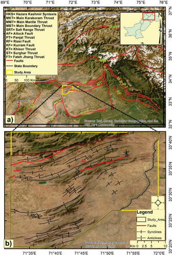
This study employs data of the Advanced Spaceborne Thermal Emission and Reflection Radiometer (ASTER) sensor to delineate and map the distribution of sedimentary lithologies in the semi-arid region of Kohat Plateau, Pakistan. False color composites (FCC) and various image transformation and enhancement techniques including the principal component analysis (PCA), minimum noise fraction (MNF), and band rationing (BR) were used successfully to differentiate four lithological classes. These lithologies include chemically/biochemically formed beds of the marine environment and detrital sequences of marginal marine to the riverine environment. FCC from original reflectance data, PCA, and BR techniques displayed more prominent lithological variation. To map the lithology and show the potential of ASTER data, field spectrometry over the barren lithologies was carried out. The end-member spectra from field spectrometry shows strong agreement with the pixels spectra from ASTER scene. The Spectral Angle Mapper (SAM) mapping method was then used to produce a classified lithological map, where the image pixels spectra proved more suitable reference, in comparison to the end-member spectra. The accuracy of the classified lithological map was evaluated based on field-based point data, which resulted an overall accuracy of 70% and a Kappa coefficient value of 0.679. Carbonates and evaporites showed relatively higher user and producer accuracies which are attributed to their topographic behavior and weathered scree over the adjacent rock unit. The final lithological map provided a clearer picture of surface geology where the existing geological maps lacked lithological continuity.
中文翻译:
评估巴基斯坦东北科哈特高原半干旱地区的 ASTER 数据和现场光谱测量的岩性判别
这项研究利用先进星载热发射和反射辐射计(ASTER)传感器的数据来描绘和绘制巴基斯坦科哈特高原半干旱地区沉积岩性的分布。假彩色复合材料 (FCC) 和各种图像转换和增强技术,包括主成分分析 (PCA)、最小噪声分数 (MNF) 和能带配给 (BR) 已成功用于区分四种岩性类别。这些岩性包括海洋环境的化学/生物化学形成的床以及边缘海洋到河流环境的碎屑序列。原始反射率数据、PCA 和 BR 技术的 FCC 显示出更突出的岩性变化。为了绘制岩性图并显示 ASTER 数据的潜力,对贫瘠岩性进行了现场光谱测量。场光谱测量的端元光谱与 ASTER 场景的像素光谱非常一致。然后使用光谱角度映射器 (SAM) 绘图方法生成分类岩性图,其中与端元光谱相比,图像像素光谱被证明是更合适的参考。基于现场点数据对分类岩性图精度进行了评估,总体精度为70%,Kappa系数值为0.679。碳酸盐和蒸发岩显示出相对较高的用户和生产者精度,这归因于它们的地形行为和邻近岩石单元上的风化碎石。最终的岩性图提供了更清晰的地表地质图,而现有的地质图缺乏岩性连续性。


 京公网安备 11010802027423号