Journal of the Indian Society of Remote Sensing ( IF 2.5 ) Pub Date : 2024-04-13 , DOI: 10.1007/s12524-024-01860-y Meriem Boultif , Billal Kheloufi , Ali Hachemi , Leila Mimeche
|
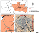
Urban flooding is the most frequent and damaging of all natural hazards, including those caused by dam breaks. One flood mitigation and control method is using flood risk maps to provide helpful information. This study aims to map the three parameters of urban flooding: exposure, vulnerability, and flood risk following a hypothetical failure of the Gazelles fountain dam (Manbaa Al-Ghozlan) in the city of Biskra (40 km downstream of the dam) through a multi-criteria decision-making process (MCDM). Six influencing factors were used for the vulnerability assessment: land use, distance from significant watercourses (Oued), distance from drainage accumulation, elevation, population density and distance from main roads. The influence of each factor was examined by attributing weights to each criterion according to its impact on urban flood vulnerability. A flood risk map that can evaluate the extent of damage and its economic implications is made based on hazard and vulnerability maps. Based on pixel values, the flood risk map has been divided into four classes: very high, high, moderate and low. The results indicate that more than 63% of the area is at high risk. The water depth in these areas may exceed 10 m in the case of dam failure. The constructed flood risk map is an informative tool to assess critical damage for decision-makers in arid and semi-arid areas.
中文翻译:
基于 GIS 的多准则决策技术和层次分析过程,用于城市干旱环境中可能溃坝的山洪风险评估:阿尔及利亚南部比斯克拉市案例研究
城市洪水是所有自然灾害中最常见、最具破坏性的,包括溃坝造成的灾害。一种洪水缓解和控制方法是使用洪水风险图来提供有用的信息。本研究旨在通过多种方法绘制城市洪水的三个参数图:假设比斯克拉市瞪羚喷泉水坝 (Manbaa Al-Ghozlan)(大坝下游 40 公里)发生故障后的暴露度、脆弱性和洪水风险。 -标准决策过程(MCDM)。脆弱性评估采用了六个影响因素:土地利用、距重要水道(Oued)的距离、距排水蓄积区的距离、海拔、人口密度和距主要道路的距离。根据对城市洪水脆弱性的影响,通过为每个标准分配权重来检验每个因素的影响。根据灾害和脆弱性地图绘制了可以评估损害程度及其经济影响的洪水风险图。根据像素值,洪水风险图分为四级:极高、高、中、低。结果表明,超过63%的地区处于高风险。如果大坝溃决,这些地区的水深可能会超过10 m。构建的洪水风险图是干旱和半干旱地区决策者评估严重损失的信息工具。


 京公网安备 11010802027423号