当前位置:
X-MOL 学术
›
Int. J. Appl. Earth Obs. Geoinf.
›
论文详情
Our official English website, www.x-mol.net, welcomes your feedback! (Note: you will need to create a separate account there.)
Interpreting differences in access and accessibility to urban greenspace through geospatial analysis
International Journal of Applied Earth Observation and Geoinformation ( IF 7.5 ) Pub Date : 2024-04-09 , DOI: 10.1016/j.jag.2024.103823 Gang Lin , Yongze Song , Dong Xu , Mohammad Shahidul Hasan Swapan , Peng Wu , Weitao Hou , Zhuoyao Xiao
International Journal of Applied Earth Observation and Geoinformation ( IF 7.5 ) Pub Date : 2024-04-09 , DOI: 10.1016/j.jag.2024.103823 Gang Lin , Yongze Song , Dong Xu , Mohammad Shahidul Hasan Swapan , Peng Wu , Weitao Hou , Zhuoyao Xiao
|
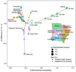
Access to urban greenspace is a fundamental requirement in providing critical ecosystem services, improving health and well-being across all ages, fostering social cohesion, and addressing prevalent health disparities in an increasingly urbanised society. Access refers to the availability of urban greenspace, while accessibility indicates the ease of reaching and enjoying these greenspaces and the quality of greenspace services. However, quantitative studies to interpret such difference between accessibility and access are limited. To contribute to this gap, this study developed a Spatial Delta Model (SDM) to quantify the difference between accessibility and access to greenspace and assess its spatial characteristics. The study examines the block-level access, accessibility, and their difference in Perth, Australia, using the SDM with a series of high-resolution greenspace and socio-economic spatial data. Access was calculated as the total greenspace near residential blocks and accessibility was derived using a modified Gaussian two-step floating catchment area (MG2SFCA) approach. Once they were quantified, a set of residential, morphological, and greenspace related factors were utilised to explain the spatial patterns of the difference between accessibility and access using a machine learning geographical detector model. The findings on the measure of the greenspace usability and the user experience further contribute to develop a green city classification system (GCCS), which is useful to informing urban planning and greenspace management.
中文翻译:

通过地理空间分析解释城市绿地的可达性和可达性的差异
获得城市绿地是提供关键生态系统服务、改善各年龄段的健康和福祉、增强社会凝聚力以及解决日益城市化的社会中普遍存在的健康差距的基本要求。可达性是指城市绿地的可利用性,而可达性则指到达和享受这些绿地的难易程度以及绿地服务的质量。然而,解释可及性和可及性之间这种差异的定量研究是有限的。为了弥补这一差距,本研究开发了空间三角洲模型(SDM)来量化可达性和绿地访问之间的差异并评估其空间特征。该研究使用 SDM 和一系列高分辨率绿地和社会经济空间数据,研究了澳大利亚珀斯的街区级可达性、可达性及其差异。通达率计算为住宅区附近的总绿地面积,通达率是使用改进的高斯两步浮动集水区(MG2SFCA)方法得出的。一旦它们被量化,一组住宅、形态和绿地相关因素就被用来解释可达性和使用机器学习地理探测器模型的可达性之间差异的空间模式。关于绿地可用性和用户体验测量的研究结果进一步有助于开发绿色城市分类系统(GCCS),该系统有助于为城市规划和绿地管理提供信息。
更新日期:2024-04-09
中文翻译:
通过地理空间分析解释城市绿地的可达性和可达性的差异
获得城市绿地是提供关键生态系统服务、改善各年龄段的健康和福祉、增强社会凝聚力以及解决日益城市化的社会中普遍存在的健康差距的基本要求。可达性是指城市绿地的可利用性,而可达性则指到达和享受这些绿地的难易程度以及绿地服务的质量。然而,解释可及性和可及性之间这种差异的定量研究是有限的。为了弥补这一差距,本研究开发了空间三角洲模型(SDM)来量化可达性和绿地访问之间的差异并评估其空间特征。该研究使用 SDM 和一系列高分辨率绿地和社会经济空间数据,研究了澳大利亚珀斯的街区级可达性、可达性及其差异。通达率计算为住宅区附近的总绿地面积,通达率是使用改进的高斯两步浮动集水区(MG2SFCA)方法得出的。一旦它们被量化,一组住宅、形态和绿地相关因素就被用来解释可达性和使用机器学习地理探测器模型的可达性之间差异的空间模式。关于绿地可用性和用户体验测量的研究结果进一步有助于开发绿色城市分类系统(GCCS),该系统有助于为城市规划和绿地管理提供信息。


 京公网安备 11010802027423号