Rendiconti Lincei. Scienze Fisiche e Naturali ( IF 1.810 ) Pub Date : 2024-04-15 , DOI: 10.1007/s12210-024-01247-8 Najeb Pendiaman , Joel Opon , Kenny Cantila
|
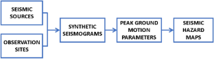
The geographical positioning of the Philippines has rendered it susceptible to devastating earthquakes, resulting in significant human and economic losses throughout its history. Given the persistent earthquake risk, there is a need to explore all available methodologies to comprehensively portray the seismic hazard profile of the country and to supplement the current Philippine Earthquake Model (PEM). Moreover, the probabilistic seismic hazard assessment (PSHA), the method employed in PEM, has faced several critiques in scholarly discourse. As such, this study employed a relatively new approach, the neo-deterministic seismic hazard assessment (NDSHA) which addresses many of the limitations associated with PSHA, to the Philippines to develop new seismic hazard maps of the country. NDSHA offers the capability to simulate ground motion parameters at bedrock levels by leveraging insights into the physical mechanisms of earthquake generation and wave propagation in a realistic medium. The application of NDSHA yielded six distinct seismic hazard maps of the Philippines containing information on calculated Peak Ground Displacement (PGD), Peak Ground Velocity (PGV), and Design Ground Acceleration (DGA). These resultant maps, which have been statistically corroborated with empirical earthquake records, identified five specific areas in the country with heightened seismic hazards. This implementation of the regional-scale NDSHA method provided new insights into the seismic hazard landscape of the Philippines, thereby enriching the reservoir of information available for infrastructure seismic assessment, analysis, and design endeavors.
中文翻译:
使用新确定性地震灾害评估方法绘制菲律宾新的地震灾害图
菲律宾的地理位置使其容易遭受毁灭性地震的影响,在其历史上造成了重大的人员和经济损失。鉴于持续的地震风险,有必要探索所有可用的方法来全面描述该国的地震灾害概况并补充当前的菲律宾地震模型(PEM)。此外,概率地震危险评估(PSHA)(PEM 中采用的方法)在学术讨论中面临着一些批评。因此,本研究采用了一种相对较新的方法,即新确定性地震灾害评估 (NDSHA),该方法解决了与 PSHA 相关的许多局限性,为菲律宾开发了该国新的地震灾害图。 NDSHA 能够利用对现实介质中地震产生和波传播的物理机制的深入了解,模拟基岩层面的地面运动参数。 NDSHA 的应用生成了菲律宾六张不同的地震危险图,其中包含计算的峰值地面位移 (PGD)、峰值地速 (PGV) 和设计地面加速度 (DGA) 的信息。这些生成的地图已与经验地震记录进行了统计证实,确定了该国地震危险性较高的五个特定区域。区域规模 NDSHA 方法的实施为菲律宾的地震灾害景观提供了新的见解,从而丰富了基础设施地震评估、分析和设计工作的信息库。


 京公网安备 11010802027423号