Journal of Geodesy ( IF 4.4 ) Pub Date : 2024-04-15 , DOI: 10.1007/s00190-024-01831-8 Kevin Ahlgren , Derek van Westrum , Brian Shaw
|
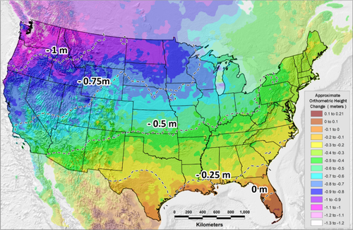
One of the most challenging environments for accurate geoid models is in high, rugged mountain areas. Orthometric heights derived from GNSS and a geoid model can easily have errors at the decimeter level. To investigate the effect of geoid model variability on the elevations of peaks in high, rugged mountain areas, this paper is focused on the “Fourteeners” of Colorado, USA (a group of about 60 peaks that are above 14,000 feet = 4267.2 m). Airborne LiDAR data are used to determine geometric (ellipsoidal) heights, which first requires removing a hybrid geoid model, as the LiDAR data is originally provided as orthometric heights. We quantify a significant improvement when using these derived ellipsoidal heights compared with the original orthometric heights: from ± 0.074 to ± 0.054 m (RMSE), an improvement of 28%. Next, a mean geoid model is determined with a relative accuracy of ± 0.06 to 0.08 m and used as a “stand in” realization of the future, official geopotential datum of the USA, NAPGD2022. Using the LiDAR ellipsoidal heights and geoid model, elevations (and uncertainties) for each of the Fourteener summits are determined and found to be, on average, 1.6 m lower than currently published values. This is a much larger change than the 0.5 m decrease expected from the new datum shift alone. The bulk of the difference is due to the original treatments of the vertical angle, triangulation data. A reanalysis of 32 of the 60 peaks shows that the historic data were indeed too high by about 1.0 m or more. Ultimately, no peak falls below the 14,000-foot level nor are any peaks elevated above this level.
中文翻译:
移动山脉:使用现代大地测量技术重新评估科罗拉多州山顶的海拔
对于精确的大地水准面模型来说,最具挑战性的环境之一是高而崎岖的山区。从 GNSS 和大地水准面模型导出的正高很容易出现分米级的误差。为了研究大地水准面模型变异性对崎岖高山地区山峰海拔的影响,本文重点关注美国科罗拉多州的“Fourteeners”(一组约 60 座海拔高于 14,000 英尺 = 4267.2 m 的山峰)。机载 LiDAR 数据用于确定几何(椭球体)高度,这首先需要删除混合大地水准面模型,因为 LiDAR 数据最初是作为正高提供的。与原始正高相比,我们量化了使用这些导出的椭球体高度时的显着改进:从 ± 0.074 到 ± 0.054 m (RMSE),提高了 28%。接下来,确定相对精度为 ± 0.06 至 0.08 m 的平均大地水准面模型,并用作未来美国官方位势基准 NAPGD2022 的“替代”实现。使用 LiDAR 椭球体高度和大地水准面模型,确定了每座 Fourteener 山峰的海拔(和不确定性),发现平均比当前公布的值低 1.6 m。这比新基准平移所预期的 0.5 m 减少要大得多。大部分差异是由于垂直角、三角测量数据的原始处理造成的。对60个山峰中的32个进行重新分析表明,历史数据确实高出约1.0m或更多。最终,没有任何山峰低于 14,000 英尺的水平,也没有任何山峰高于此水平。


 京公网安备 11010802027423号