International Journal of Disaster Risk Science ( IF 4 ) Pub Date : 2024-04-16 , DOI: 10.1007/s13753-024-00554-w Monia Del Pinto , Ksenia Chmutina , Falli Palaiologou , Lee Bosher
|
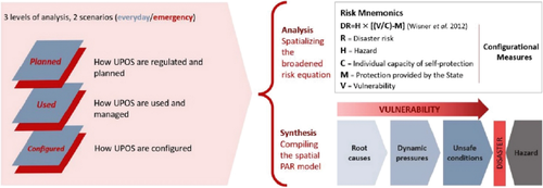
The notion of “spatial vulnerability” is present in most disaster studies with a strong geographical connotation and accordingly is adopted at all scales, including the urban. While enabling mapping and visualizing risk patterns at macroscales, this geocentric foundation fails to capture disaster risk dynamics associated with the urban spatial network—an element that plays a significant role in the everyday and emergency functioning of cities, enabling users’ movement and interaction. Yet, urban vulnerability assessment overlooks this aspect and thus leaves urban disaster risk mechanisms partially unexplored. This study investigated the role of the network of urban public open spaces (UPOS) in the creation and progression of urban disaster risk in earthquake-prone settlements. Through a multimethod approach that integrates quantitative and qualitative methods and explores spatial configuration, planning policies, and practices of use of UPOS in everyday and emergency scenarios, our study demonstrated that UPOS configuration plays an active role in urban disaster risk. Urban public open spaces impact risk by influencing the exposure of pedestrians and their capacity for self-protection. The study further reconceptualized spatial vulnerability at the urban scale, as the fraction of vulnerability associated to the spatial network, highlighting the interplay of planning policies and spatial practices in its production and progression. Our findings make the notion of spatial vulnerability less ambiguous at the urban scale, by viewing the variable as an imbalance in capacities and exposure that generates spatially unsafe conditions. This refined conceptualization of spatial vulnerability becomes a lens for a more granular approach to urban disaster risk reduction and city planning by identifying and integrating sociospatial considerations.
中文翻译:
空间网络在城市灾害风险变化中的作用:重新构想城市尺度的空间脆弱性概念
“空间脆弱性”的概念出现在大多数灾害研究中,具有很强的地理内涵,因此在包括城市在内的所有尺度上都得到采用。虽然能够在宏观尺度上绘制和可视化风险模式,但这种以地心为中心的基础无法捕捉与城市空间网络相关的灾害风险动态,而城市空间网络在城市的日常和紧急功能中发挥着重要作用,使用户能够移动和互动。然而,城市脆弱性评估忽视了这一方面,从而导致城市灾害风险机制部分未被探索。本研究调查了城市公共开放空间(UPOS)网络在地震多发地区城市灾害风险的产生和发展中的作用。通过综合定量和定性方法的多种方法,探索空间配置、规划政策以及 UPOS 在日常和紧急情况下的使用实践,我们的研究表明 UPOS 配置在城市灾害风险中发挥着积极作用。城市公共开放空间通过影响行人的暴露程度及其自我保护能力来影响风险。该研究进一步重新概念化了城市尺度的空间脆弱性,作为与空间网络相关的脆弱性的一部分,强调了规划政策和空间实践在其产生和发展中的相互作用。我们的研究结果使空间脆弱性的概念在城市尺度上不再那么模糊,将变量视为产生空间不安全条件的能力和暴露的不平衡。通过识别和整合社会空间考虑因素,这种对空间脆弱性的精细概念化成为减少城市灾害风险和城市规划的更精细方法的镜头。


 京公网安备 11010802027423号