当前位置:
X-MOL 学术
›
Remote Sens. Environ.
›
论文详情
Our official English website, www.x-mol.net, welcomes your feedback! (Note: you will need to create a separate account there.)
Satellite-based tracking of reservoir operations for flood management during the 2018 extreme weather event in Kerala, India
Remote Sensing of Environment ( IF 13.5 ) Pub Date : 2024-04-11 , DOI: 10.1016/j.rse.2024.114149 Sarath Suresh , Faisal Hossain , Sanchit Minocha , Pritam Das , Shahzaib Khan , Hyongki Lee , Konstantinos Andreadis , Perry Oddo
Remote Sensing of Environment ( IF 13.5 ) Pub Date : 2024-04-11 , DOI: 10.1016/j.rse.2024.114149 Sarath Suresh , Faisal Hossain , Sanchit Minocha , Pritam Das , Shahzaib Khan , Hyongki Lee , Konstantinos Andreadis , Perry Oddo
|
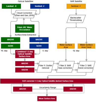
Uncoordinated management of hydropower dams during extreme and unexpected precipitation events in mountainous terrain can have disastrous consequences due to the competing nature of flood control and hydropower generation. Numerous cases of flooding events that have been exacerbated due to insufficient storage conditions in hydropower dams have been reported worldwide. There is a need for a scalable and publicly-accessible monitoring framework that is capable of providing reliable, near-real time, and transparent reservoir operations data. A fully satellite-based framework is the most viable solution to build such capability. The Reservoir Assessment Tool (RAT 3.0), which utilises high frequency remote sensing-based surface area and reservoir storage estimation alongside hydrological modelled inflow was applied here for the 2018 Kerala floods in India as a globally representative case for a mountainous river basin with high precipitation and hydropower dams. Application of satellite-based RAT 3.0 in monitoring the state of 19 reservoirs in Kerala during the flood event showed very promising results. In general, RAT 3.0, using satellite remote sensing, was found to be able to capture the temporal trend of the reservoir storage and pinpoint the sudden shift in filling or release decisions made by the dam operator. Inflow modelling in such regions was found to require careful calibration with identification of reservoirs that are heavily regulated being a critical aspect. The perennial high cloud cover in such regions necessitate and highlights the central role played by microwave and radar-based satellite sensors, such as the Surface Water and Ocean Topography (SWOT) mission, in tracking reservoir state. An operational version of RAT 3.0 for stakeholder agencies tailored for hydropower dams operating in high precipitation and mountainous environments is a real-world outcome of this study.
中文翻译:

2018 年印度喀拉拉邦极端天气事件期间基于卫星的水库运行跟踪以进行洪水管理
由于防洪和水力发电的竞争性质,在山区发生极端和意外降水事件期间,水电大坝的不协调管理可能会造成灾难性后果。世界各地已报告多起因水电站大坝蓄水条件不足而加剧的洪水事件。需要一个可扩展且可公开访问的监测框架,能够提供可靠、近实时和透明的水库运营数据。完全基于卫星的框架是建立这种能力的最可行的解决方案。水库评估工具 (RAT 3.0) 利用基于高频遥感的表面积和水库蓄水量估算以及水文模型入流,应用于 2018 年印度喀拉拉邦洪水,作为高降水量山区河流流域的全球代表性案例和水力发电大坝。应用基于卫星的 RAT 3.0 监测喀拉拉邦 19 个水库在洪水期间的状况,显示出非常有希望的结果。总体而言,RAT 3.0 使用卫星遥感技术,能够捕捉水库蓄水量的时间趋势,并查明大坝运营商蓄水或泄水决策的突然变化。研究发现,这些地区的流入模型需要仔细校准,其中识别受到严格监管的水库是一个关键方面。这些地区常年的高云量需要并凸显基于微波和雷达的卫星传感器在跟踪水库状态方面发挥的核心作用,例如地表水和海洋地形 (SWOT) 任务。本研究的现实成果是为利益相关机构量身定制的 RAT 3.0 运行版本,专为在高降水量和山区环境中运行的水电大坝而设计。
更新日期:2024-04-11
中文翻译:
2018 年印度喀拉拉邦极端天气事件期间基于卫星的水库运行跟踪以进行洪水管理
由于防洪和水力发电的竞争性质,在山区发生极端和意外降水事件期间,水电大坝的不协调管理可能会造成灾难性后果。世界各地已报告多起因水电站大坝蓄水条件不足而加剧的洪水事件。需要一个可扩展且可公开访问的监测框架,能够提供可靠、近实时和透明的水库运营数据。完全基于卫星的框架是建立这种能力的最可行的解决方案。水库评估工具 (RAT 3.0) 利用基于高频遥感的表面积和水库蓄水量估算以及水文模型入流,应用于 2018 年印度喀拉拉邦洪水,作为高降水量山区河流流域的全球代表性案例和水力发电大坝。应用基于卫星的 RAT 3.0 监测喀拉拉邦 19 个水库在洪水期间的状况,显示出非常有希望的结果。总体而言,RAT 3.0 使用卫星遥感技术,能够捕捉水库蓄水量的时间趋势,并查明大坝运营商蓄水或泄水决策的突然变化。研究发现,这些地区的流入模型需要仔细校准,其中识别受到严格监管的水库是一个关键方面。这些地区常年的高云量需要并凸显基于微波和雷达的卫星传感器在跟踪水库状态方面发挥的核心作用,例如地表水和海洋地形 (SWOT) 任务。本研究的现实成果是为利益相关机构量身定制的 RAT 3.0 运行版本,专为在高降水量和山区环境中运行的水电大坝而设计。


 京公网安备 11010802027423号