当前位置:
X-MOL 学术
›
Remote Sens. Environ.
›
论文详情
Our official English website, www.x-mol.net, welcomes your feedback! (Note: you will need to create a separate account there.)
Assessment of snow cover mapping algorithms from Landsat surface reflectance data and application to automated snowline delineation
Remote Sensing of Environment ( IF 13.5 ) Pub Date : 2024-04-17 , DOI: 10.1016/j.rse.2024.114163 Xiongxin Xiao , Shuang Liang
Remote Sensing of Environment ( IF 13.5 ) Pub Date : 2024-04-17 , DOI: 10.1016/j.rse.2024.114163 Xiongxin Xiao , Shuang Liang
|
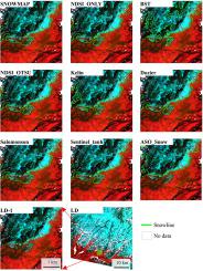
The abundance of remote sensing imagery available has been extensively used for mapping snow cover extent in mountainous regions. However, previous studies have paid little attention to quantifying the uncertainties inherent in snow cover mapping algorithms when using Landsat observations, particularly in the context of delineating the snowline—a pivotal parameter for understanding the spatiotemporal dynamics of snow cover. Additionally, there is an urgent need for an automated processing approach capable of monitoring alpine snowline across expansive mountainous terrains. This study squarely addresses these gaps by primarily focusing on the precise delineation of snowline and the quantification of disparities in determining snowline elevation using eight snow cover mapping algorithms. Our approach is twofold: initially, we comprehensively assessed eight snow cover mapping algorithms using Landsat 8/9 data, contrasting their performance against high-spatial-resolution (3 m) snow observations. Subsequently, we introduced a novel snowline delineation method, termed Automated Snowline Delineation on Binary Snow Cover (ASLD-BSC). This method is designed to determine snowline on binary snow cover maps generated by these eight algorithms and was rigorously assessed across 15 catchment basins in America. The comparative analysis of the eight snow cover algorithms revealed a hierarchy of performance, with three algorithms employing multi-band decision trees exhibiting the highest proficiency in snow cover mapping. They were succeeded by four NDSI-based algorithms, with the Blue Snow Threshold algorithm ranking the lowest in terms of performance. Furthermore, our assessment demonstrated that the proposed snowline delineation method, ASLD-BSC, successfully mitigated approximately 1/3 of misclassification pixels and effectively created robust snowline patterns for each binary snow map. When scrutinizing snowline elevation, we observed striking variations in elevation differences among the eight snow cover mapping algorithms relative to the reference snowline elevation (average snowline elevation: 121 m ∼ 258 m; bottom 10% snowline elevation: 253 m ∼ 512 m; top 10% snowline elevation: 206 m ∼ 344 m). These findings underscore the pivotal role that the quality of binary snow maps plays in determining the accuracy of snowline and snowline elevation. Importantly, this study provides a comprehensive guide for selecting appropriate snow cover mapping algorithms, facilitating effective monitoring of Landsat-based snow cover in mountainous areas.
中文翻译:

根据 Landsat 表面反射率数据评估积雪绘图算法及其在自动雪线描绘中的应用
丰富的遥感图像已被广泛用于绘制山区积雪范围。然而,以前的研究很少关注在使用陆地卫星观测时量化积雪绘图算法固有的不确定性,特别是在描绘雪线(理解积雪时空动态的关键参数)的背景下。此外,迫切需要一种能够监测广阔山区的高山雪线的自动化处理方法。这项研究通过主要关注雪线的精确描绘以及使用八种积雪地图算法确定雪线高程的差异量化来解决这些差距。我们的方法是双重的:最初,我们使用 Landsat 8/9 数据全面评估了八种积雪绘图算法,将它们的性能与高空间分辨率 (3 m) 积雪观测进行了对比。随后,我们引入了一种新颖的雪线描绘方法,称为二元雪盖自动雪线描绘(ASLD-BSC)。该方法旨在确定由这八种算法生成的二值积雪地图上的雪线,并在美国 15 个流域进行了严格评估。对八种积雪算法的比较分析揭示了性能的层次结构,其中三种采用多波段决策树的算法在积雪映射方面表现出最高的熟练程度。四种基于 NDSI 的算法取代了它们,其中 Blue Snow Threshold 算法在性能方面排名最低。此外,我们的评估表明,所提出的雪线描绘方法 ASLD-BSC 成功减少了大约 1/3 的错误分类像素,并有效地为每个二值雪图创建了稳健的雪线模式。在检查雪线高程时,我们观察到八种积雪覆盖绘图算法相对于参考雪线高程的高程差异存在显着变化(平均雪线高程:121 m ∼ 258 m;底部 10% 雪线高程:253 m ∼ 512 m;前 10 名) %雪线高程:206 m ∼ 344 m)。这些发现强调了二值雪图的质量在确定雪线和雪线高程的准确性方面发挥的关键作用。重要的是,这项研究为选择合适的积雪绘图算法提供了全面的指导,有助于有效监测山区的陆地卫星积雪。
更新日期:2024-04-17
中文翻译:
根据 Landsat 表面反射率数据评估积雪绘图算法及其在自动雪线描绘中的应用
丰富的遥感图像已被广泛用于绘制山区积雪范围。然而,以前的研究很少关注在使用陆地卫星观测时量化积雪绘图算法固有的不确定性,特别是在描绘雪线(理解积雪时空动态的关键参数)的背景下。此外,迫切需要一种能够监测广阔山区的高山雪线的自动化处理方法。这项研究通过主要关注雪线的精确描绘以及使用八种积雪地图算法确定雪线高程的差异量化来解决这些差距。我们的方法是双重的:最初,我们使用 Landsat 8/9 数据全面评估了八种积雪绘图算法,将它们的性能与高空间分辨率 (3 m) 积雪观测进行了对比。随后,我们引入了一种新颖的雪线描绘方法,称为二元雪盖自动雪线描绘(ASLD-BSC)。该方法旨在确定由这八种算法生成的二值积雪地图上的雪线,并在美国 15 个流域进行了严格评估。对八种积雪算法的比较分析揭示了性能的层次结构,其中三种采用多波段决策树的算法在积雪映射方面表现出最高的熟练程度。四种基于 NDSI 的算法取代了它们,其中 Blue Snow Threshold 算法在性能方面排名最低。此外,我们的评估表明,所提出的雪线描绘方法 ASLD-BSC 成功减少了大约 1/3 的错误分类像素,并有效地为每个二值雪图创建了稳健的雪线模式。在检查雪线高程时,我们观察到八种积雪覆盖绘图算法相对于参考雪线高程的高程差异存在显着变化(平均雪线高程:121 m ∼ 258 m;底部 10% 雪线高程:253 m ∼ 512 m;前 10 名) %雪线高程:206 m ∼ 344 m)。这些发现强调了二值雪图的质量在确定雪线和雪线高程的准确性方面发挥的关键作用。重要的是,这项研究为选择合适的积雪绘图算法提供了全面的指导,有助于有效监测山区的陆地卫星积雪。


 京公网安备 11010802027423号