Natural Hazards ( IF 3.7 ) Pub Date : 2024-04-17 , DOI: 10.1007/s11069-024-06599-w A. O. Turkel , Hasan Zaifoglu , A. M. Yanmaz
|
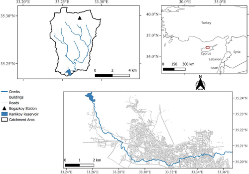
One of the most perilous natural hazards is flooding resulting from dam failure, which can devastate downstream infrastructure and lead to significant human casualties. In recent years, the frequency of flash floods in the northern part of Nicosia, Cyprus, has increased. This area faces increased risk as it lies downstream of the Kanlikoy Dam, an aging earth-fill dam constructed over 70 years ago. In this study, we aim to assess potential flood hazards stemming from three distinct failure scenarios: piping, 100-year rainfall, and probable maximum precipitation (PMP). To achieve this, HEC-HMS hydrologic model findings were integrated into 2D HEC-RAS hydraulic models to simulate flood hydrographs and generate flood inundation and hazard maps. For each scenario, Monte Carlo simulations using McBreach software produced four hydrographs corresponding to exceedance probabilities of 90%, 50%, 10%, and 1%. The results indicate that all dam breach scenarios pose a significant threat to agricultural and residential areas, leading to the destruction of numerous buildings, roads, and infrastructures. Particularly, Scenario 3, which includes PMP, was identified as the most destructive, resulting in prevailing flood hazard levels of H5 and H6 in the inundated areas. The proportion of inundated areas in these high hazard levels varied between 52.8% and 57.4%, with the number of vulnerable structures increasing from 248 to 321 for exceedance probabilities of 90% and 1%, respectively. Additionally, the number of flooded buildings ranged from 842 to 935, and 26 to 34 km of roads were found to be inundated in this scenario. These findings revealed the need for authorities to develop comprehensive evacuation plans and establish an efficient warning system to mitigate the flood risks associated with dam failure.
中文翻译:
大坝溃决场景的概率建模:塞浦路斯 Kanlikoy 大坝案例研究
最危险的自然灾害之一是大坝溃决导致的洪水,它可能会破坏下游基础设施并导致重大人员伤亡。近年来,塞浦路斯尼科西亚北部地区山洪爆发频率有所增加。该地区位于 Kanlikoy 大坝下游,面临着更大的风险,这是一座 70 多年前建造的老化土坝。在这项研究中,我们的目标是评估三种不同故障情景造成的潜在洪水危害:管道、100 年降雨量和可能最大降水量 (PMP)。为了实现这一目标,HEC-HMS 水文模型结果被集成到二维 HEC-RAS 水力模型中,以模拟洪水过程线并生成洪水淹没和灾害图。对于每种情况,使用 McBreach 软件进行蒙特卡罗模拟生成了对应于 90%、50%、10% 和 1% 超出概率的四种过程线。结果表明,所有溃坝情景都会对农业和居民区构成重大威胁,导致大量建筑物、道路和基础设施被毁。特别是,包括PMP在内的情景3被认为是最具破坏性的,导致受灾地区普遍存在H5和H6的洪水危险级别。这些高危险级别的淹没区域比例在 52.8% 和 57.4% 之间变化,脆弱建筑物的数量从 248 个增加到 321 个,超标概率分别为 90% 和 1%。此外,被淹没的建筑物数量从842座到935座不等,在这种情况下发现26到34公里的道路被淹没。这些调查结果表明,当局需要制定全面的疏散计划并建立有效的预警系统,以减轻与大坝溃决相关的洪水风险。


 京公网安备 11010802027423号