Scientific Reports ( IF 4.6 ) Pub Date : 2024-04-17 , DOI: 10.1038/s41598-024-59123-2 Z. Ferris , E. Ribeiro , T. Nagata , R. van Woesik
|
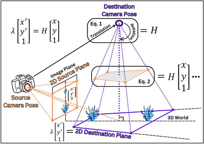
Ever since the first image of a coral reef was captured in 1885, people worldwide have been accumulating images of coral reefscapes that document the historic conditions of reefs. However, these innumerable reefscape images suffer from perspective distortion, which reduces the apparent size of distant taxa, rendering the images unusable for quantitative analysis of reef conditions. Here we solve this century-long distortion problem by developing a novel computer-vision algorithm, ReScape, which removes the perspective distortion from reefscape images by transforming them into top-down views, making them usable for quantitative analysis of reef conditions. In doing so, we demonstrate the first-ever ecological application and extension of inverse-perspective mapping—a foundational technique used in the autonomous-driving industry. The ReScape algorithm is composed of seven functions that (1) calibrate the camera lens, (2) remove the inherent lens-induced image distortions, (3) detect the scene’s horizon line, (4) remove the camera-roll angle, (5) detect the transformable reef area, (6) detect the scene’s perspective geometry, and (7) apply brute-force inverse-perspective mapping. The performance of the ReScape algorithm was evaluated by transforming the perspective of 125 reefscape images. Eighty-five percent of the images had no processing errors and of those, 95% were successfully transformed into top-down views. ReScape was validated by demonstrating that same-length transects, placed increasingly further from the camera, became the same length after transformation. The mission of the ReScape algorithm is to (i) unlock historical information about coral-reef conditions from previously unquantified periods and localities, (ii) enable citizen scientists and recreational photographers to contribute reefscape images to the scientific process, and (iii) provide a new survey technique that can rigorously assess relatively large areas of coral reefs, and other marine and even terrestrial ecosystems, worldwide. To facilitate this mission, we compiled the ReScape algorithm into a free, user-friendly App that does not require any coding experience. Equipped with the ReScape App, scientists can improve the management and prediction of the future of coral reefs by uncovering historical information from reefscape-image archives and by using reefscape images as a new, rapid survey method, opening a new era of coral-reef monitoring.
中文翻译:
ReScape:转换珊瑚礁景观图像以进行定量分析
自从 1885 年拍摄到第一张珊瑚礁图像以来,世界各地的人们一直在积累记录珊瑚礁历史状况的珊瑚礁景观图像。然而,这些无数的珊瑚礁景观图像存在透视失真,这减少了远处类群的表观尺寸,使得图像无法用于珊瑚礁状况的定量分析。在这里,我们通过开发一种新颖的计算机视觉算法ReScape解决了这个长达一个世纪的失真问题,该算法通过将珊瑚礁景观图像转换为自上而下的视图来消除透视失真,使它们可用于珊瑚礁状况的定量分析。在此过程中,我们展示了逆透视映射的首次生态应用和扩展——这是自动驾驶行业使用的基础技术。ReScape算法由七个函数组成,这些函数 (1) 校准相机镜头,(2) 消除镜头引起的固有图像失真,(3) 检测场景的地平线,(4) 消除相机滚动角度,(5 ) 检测可变形珊瑚礁区域,(6) 检测场景的透视几何形状,以及 (7) 应用强力逆透视贴图。通过变换 125 张礁石景观图像的视角来评估ReScape算法的性能。 85% 的图像没有处理错误,其中 95% 成功转换为自上而下的视图。ReScape 的验证是通过证明距离相机越来越远的相同长度的横断面在变换后变得相同的长度。ReScape算法的使命是 (i) 解锁有关以前未量化的时期和地点的珊瑚礁状况的历史信息,(ii) 使公民科学家和休闲摄影师能够为科学过程贡献珊瑚礁景观图像,以及 (iii) 提供新的调查技术可以严格评估世界范围内相对较大面积的珊瑚礁以及其他海洋甚至陆地生态系统。为了促进这一使命,我们将ReScape算法编译成一个免费的、用户友好的应用程序,不需要任何编码经验。配备ReScape应用程序后,科学家可以通过从珊瑚礁景观图像档案中发现历史信息,并使用珊瑚礁景观图像作为一种新的快速调查方法,改善珊瑚礁未来的管理和预测,开启珊瑚礁监测的新时代。


 京公网安备 11010802027423号