当前位置:
X-MOL 学术
›
Ore Geol. Rev.
›
论文详情
Our official English website, www.x-mol.net, welcomes your feedback! (Note: you will need to create a separate account there.)
Comprehensive Multi-Source remote sensing data integration for enhanced mineralization alteration extraction and geological structure interpretation in the Lala region of Sichuan Province
Ore Geology Reviews ( IF 3.3 ) Pub Date : 2024-04-16 , DOI: 10.1016/j.oregeorev.2024.106032 Geng Zhang , Zhifang Zhao , Xinle Zhang , Xiatao Wu , Yangfan Zheng , Lunxin Feng , Ziqi Huang
Ore Geology Reviews ( IF 3.3 ) Pub Date : 2024-04-16 , DOI: 10.1016/j.oregeorev.2024.106032 Geng Zhang , Zhifang Zhao , Xinle Zhang , Xiatao Wu , Yangfan Zheng , Lunxin Feng , Ziqi Huang
|
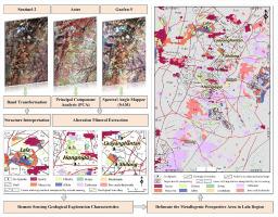
The Lala Copper Deposit, situated in the Kangdian Copper Belt, is a substantial copper reservoir. In recent years, extensive exploration for copper resources in the region has become critically important due to the growing demand for Lala copper deposit resources. Alteration minerals, serving as crucial indicators for prospecting, have not undergone systematic study regarding their spatial distribution and remote sensing geological structural features in the Iron Oxide-Copper-Gold (IOCG) type deposits of the Lala region. Multispectral and hyperspectral remote sensing data prove to be effective tools for exploring mineralization information. In this study, Advanced Spaceborne Thermal Emission and Reflection Radiometer (ASTER) data and Principal Component Analysis (PCA) are utilized to extract the distribution of carbonate, iron oxides/hydroxide and quartz minerals. Gaofen-5 (GF-5) data and the Spectral Angle Mapper (SAM) method are applied to extract minerals such as albite, biotite, chlorite, hornblende and muscovite. Sentinel-2 data are employed for remote sensing geological structure interpretation in the Lala region. The results of remote sensing alteration anomaly extraction are validated through field verification, indoor spectral scanning analysis, and the calculation of the SID_SAM index. The mineralization alteration information extracted through remote sensing aligns well with field conditions upon verification. The SID_SAM indices for ASTER and GF-5 extraction results are 0.0272 and 0.0177, respectively, indicating a 35% improvement in GF-5 performance. This suggests that GF-5 hyperspectral data demonstrate superior capability in identifying alteration minerals compared to ASTER multispectral data. Finally, through a comprehensive analysis of remote sensing alteration minerals and structural features of known deposits, the study summarized the remote sensing geological exploration characteristics of IOCG-type deposits in the Lala copper deposit area. Seven new prospective areas for copper mineralization are ultimately identified. These research findings provide valuable references for the next exploration phase of similar deposits in the region.
中文翻译:

综合多源遥感数据集成,增强四川省拉拉地区矿化蚀变提取和地质结构解释
拉拉铜矿床位于康甸铜矿带内,是一个重要的铜矿藏。近年来,由于拉拉铜矿资源需求不断增长,对该地区铜资源的广泛勘探变得至关重要。拉拉地区氧化铁-铜-金(IOCG)型矿床作为找矿的重要指标,蚀变矿物的空间分布和遥感地质构造特征尚未进行系统研究。多光谱和高光谱遥感数据被证明是探索矿化信息的有效工具。在这项研究中,利用先进星载热发射和反射辐射计 (ASTER) 数据和主成分分析 (PCA) 来提取碳酸盐、铁氧化物/氢氧化物和石英矿物的分布。高分五号(GF-5)数据和光谱角映射器(SAM)方法用于提取钠长石、黑云母、绿泥石、角闪石和白云母等矿物。 Sentinel-2数据用于拉拉地区遥感地质结构解释。通过现场验证、室内光谱扫描分析和SID_SAM指数计算,验证了遥感蚀变异常提取的结果。遥感提取的矿化蚀变信息经验证与现场情况吻合较好。 ASTER 和 GF-5 提取结果的 SID_SAM 指数分别为 0.0272 和 0.0177,表明 GF-5 性能提高了 35%。这表明,与 ASTER 多光谱数据相比,GF-5 高光谱数据在识别蚀变矿物方面表现出卓越的能力。最后,通过对已知矿床遥感蚀变矿物及构造特征的综合分析,总结了拉拉铜矿区IOCG型矿床遥感地质勘查特征。最终确定了七个新的铜矿化前景区域。这些研究成果为下一步该地区类似矿床的勘探提供了宝贵的参考。
更新日期:2024-04-16
中文翻译:
综合多源遥感数据集成,增强四川省拉拉地区矿化蚀变提取和地质结构解释
拉拉铜矿床位于康甸铜矿带内,是一个重要的铜矿藏。近年来,由于拉拉铜矿资源需求不断增长,对该地区铜资源的广泛勘探变得至关重要。拉拉地区氧化铁-铜-金(IOCG)型矿床作为找矿的重要指标,蚀变矿物的空间分布和遥感地质构造特征尚未进行系统研究。多光谱和高光谱遥感数据被证明是探索矿化信息的有效工具。在这项研究中,利用先进星载热发射和反射辐射计 (ASTER) 数据和主成分分析 (PCA) 来提取碳酸盐、铁氧化物/氢氧化物和石英矿物的分布。高分五号(GF-5)数据和光谱角映射器(SAM)方法用于提取钠长石、黑云母、绿泥石、角闪石和白云母等矿物。 Sentinel-2数据用于拉拉地区遥感地质结构解释。通过现场验证、室内光谱扫描分析和SID_SAM指数计算,验证了遥感蚀变异常提取的结果。遥感提取的矿化蚀变信息经验证与现场情况吻合较好。 ASTER 和 GF-5 提取结果的 SID_SAM 指数分别为 0.0272 和 0.0177,表明 GF-5 性能提高了 35%。这表明,与 ASTER 多光谱数据相比,GF-5 高光谱数据在识别蚀变矿物方面表现出卓越的能力。最后,通过对已知矿床遥感蚀变矿物及构造特征的综合分析,总结了拉拉铜矿区IOCG型矿床遥感地质勘查特征。最终确定了七个新的铜矿化前景区域。这些研究成果为下一步该地区类似矿床的勘探提供了宝贵的参考。


 京公网安备 11010802027423号