Environmental Science and Pollution Research ( IF 5.8 ) Pub Date : 2024-04-24 , DOI: 10.1007/s11356-024-33379-7 Tewabe Melkamu , Murugesan Bagyaraj , Melkamu Adimaw , Amare Berihun
|
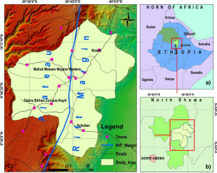
The devastating nature of landslides demands a thorough understanding of their spatial distribution and the risks they pose to human settlements and infrastructural assets. In this study, we employed a combination of Interferometric Synthetic Aperture Radar (InSAR) and Geographic Information System (GIS) techniques to explore the western escarpment of the Main Ethiopian Rift, with a focus on selected districts within the northern Shewa Zone, Ethiopia. By analyzing the SAR data, we derived 28 displacement maps and utilized them to create a comprehensive landslide hazard zonation map. The results indicated significant ground displacement, particularly along the rift margins and areas characterized by rugged terrain. The hazard zones were classified based on their level of risk, with 44% classified as very low, 24% as low, 5% as moderate, 13% as high, and 14% as very high hazard zones. The accuracy of our results was evaluated using receiver operating characteristic (ROC) analysis, which was conducted utilizing landslide inventory data. The analysis demonstrated a remarkable area under the curve (AUC) value of 0.848, providing strong evidence for the validity of our findings. Additionally, our study involved a spatial and statistical assessment of major infrastructure, revealing that 20 to 28% of these properties were in hazard zones ranging from moderate to very high levels, which calls for efficient risk-reduction actions. Therefore, this finding enables stakeholders to identify high-risk areas, prioritize mitigation efforts, and minimize the impact of landslide disasters.
中文翻译:
基于 InSAR 的滑坡灾害测绘和埃塞俄比亚北谢瓦地区选定地区的风险基础设施识别
山体滑坡的破坏性要求我们全面了解其空间分布及其对人类住区和基础设施资产造成的风险。在这项研究中,我们结合了干涉合成孔径雷达(InSAR)和地理信息系统(GIS)技术来探索埃塞俄比亚主裂谷的西部悬崖,重点关注埃塞俄比亚谢瓦北部地区的选定地区。通过分析 SAR 数据,我们得出了 28 个位移图,并利用它们创建了全面的滑坡灾害分区图。结果表明存在显着的地面位移,特别是沿着裂谷边缘和地形崎岖的地区。危险区域根据风险级别进行分类,其中 44% 为极低危险区域,24% 为低危险区域,5% 为中度危险区域,13% 为高危险区域,14% 为极高危险区域。我们的结果的准确性是通过接收器操作特征(ROC)分析来评估的,该分析是利用山体滑坡清单数据进行的。分析显示曲线下面积 (AUC) 值为 0.848,为我们研究结果的有效性提供了有力的证据。此外,我们的研究还涉及对主要基础设施的空间和统计评估,结果表明,其中 20% 至 28% 的房产位于中等至极高级别的危险区域,这需要采取有效的降低风险行动。因此,这一发现使利益相关者能够识别高风险区域,优先考虑缓解措施,并最大限度地减少滑坡灾害的影响。


 京公网安备 11010802027423号