


With few exceptions, most important cave and rockshelter sites in the Great Basin had been professionally excavated or severely damaged by looters by the end of the twentieth century. As a result, researchers have increasingly turned their attention to previously excavated sites. In some cases, such as the Paisley Caves (Jenkins et al. Reference Jenkins, Davis, Stafford, Campos, Hockett, Jones and Cummings2012) and Connley Caves (Jenkins et al. Reference Jenkins, Holcomb and McDonough2017; McDonough et al. Reference McDonough, Kennedy, Rosencrance, Holcomb, Jenkins and Puseman2022), these efforts have changed our understanding of the peopling of the Great Basin. In others, such as Fort Rock Cave (Connolly et al. Reference Connolly, Finley, Smith, Jenkins and Endzweig2017), renewed work has shown that some sites are irreparably damaged. In both cases—the good and the bad—revisiting old sites has allowed archaeologists to evaluate the remaining potential of important locales.
The archaeological significance of Leonard Rockshelter (26Pe14; herein referred to as LRS) was first recognized in 1936 by guano miner Thomas Derby, who contacted Robert Heizer at the University of California Berkeley (UCB). Derby told Heizer that he had discovered a complete atlatl dart tipped with a sharpened greasewood foreshaft (but lacking a stone point) and a string of approximately 50 Olivella shell beads in the guano layer (Heizer Reference Heizer1938)—a claim supported by Heizer's discovery of three greasewood foreshafts and a broken obsidian biface during his first visit the site in 1937 (Heizer Reference Heizer1951). Heizer returned to the site in 1950 to carry out more substantial excavations and obtained some of the first radiocarbon-dated samples from an archaeological site (Arnold and Libby Reference Arnold and Libby1950). Among these was a date of 11,120 ± 570 14C BP (14,940–11,620 cal BP) on bat guano–rich sediment from the site's lowest artifact-bearing stratum.Footnote 1 Heizer (Reference Heizer1951:94) recovered two obsidian flakes “from the very bottom of this level,” which he believed were the oldest artifacts at the site, and a few other artifacts from higher up in the guano layer, including at least two Olivella shell beads, a chert biface, and bits of cordage.Footnote 2, Footnote 3 These findings led Heizer (Reference Heizer1951:93) to conclude that “there can be no question of the presence of man during the period that bat guano was being laid down.” This assertion was supported when he obtained a radiocarbon date of 7040 ± 350 14C BP (8600–7170 cal BP) on the foreshafts he collected in 1937.
Heizer's (Reference Heizer1951) argument for an early occupation at LRS, supported by obsidian flakes purportedly associated with dated late Pleistocene deposits and artifacts directly dated to the initial middle Holocene, piqued our interest. The association of the flakes with guano dated to 14,940–11,620 cal BP was particularly intriguing because that interval encompasses both the earliest evidence of human activity at the Paisley Caves (14,200 cal BP; Shillito et al. Reference Shillito, Whelton, Blong, Jenkins, Connolly and Bull2020) and the Clovis Era (13,050–12,750 cal BP; Waters et al. Reference Waters, Stafford and Carlson2020). If we could replicate Heizer's findings, then LRS might add to our understanding of how people explored and settled the western Great Basin. We returned to LRS in 2018 and 2019 with two goals. First, we sought to relocate an intact profile from Heizer's Area B excavation block, where he recovered the obsidian flakes and other artifacts. Second, we sought to rerecord and redate the strata in that profile. We believed that those efforts would allow us to evaluate Heizer's claim that people first visited LRS during the late Pleistocene.
History of Work at Leonard Rockshelter
Leonard Rockshelter is a north-facing, wave-cut shelter located in the West Humboldt Range of western Nevada on the traditional lands of the Northern Paiute (Figure 1). It sits at the base of a near-vertical rock outcrop at an elevation of 1,285 m (4,216 ft.) above sea level (asl), the lower half of which is coated by a thick mantle of calcareous tufa deposited by Lake Lahontan (Byrne et al. Reference Byrne, Roger and Heizer1979).Footnote 4 The shelter overlooks the Humboldt River and the Humboldt Sink, which is typically the terminus of the river.
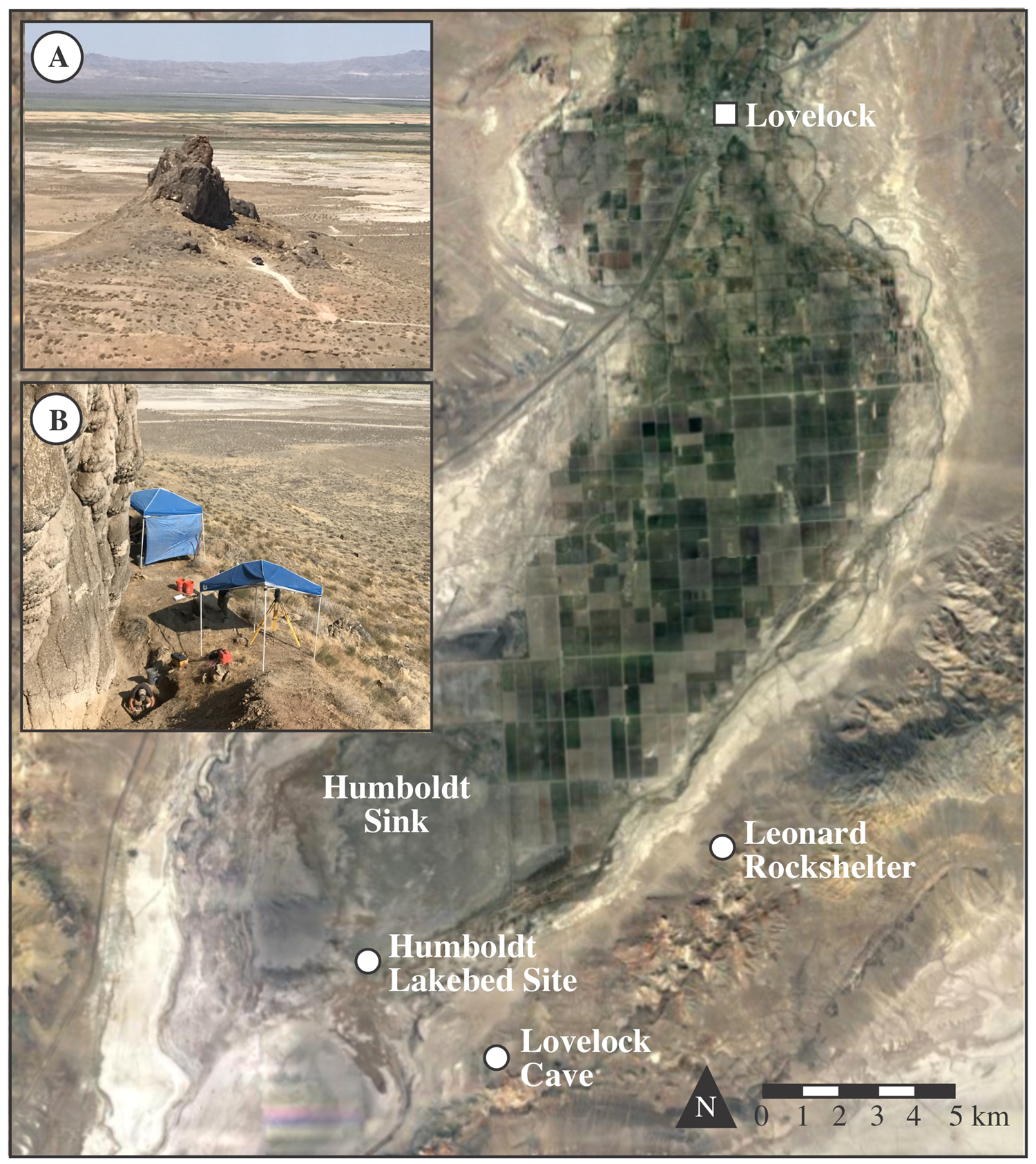
Figure 1. Location of Leonard Rockshelter, Lovelock Cave, and the Humboldt Lakebed Site. Inset A: Steep outcrop beneath which the shelter sites, looking northwest. Inset B: Overview of UNR's 2018 work in Heizer's Excavation Area B, looking northwest. (Color online)
During wet periods, the Humboldt Sink holds a shallow lake ringed by marshes fed by the Humboldt River. During particularly wet periods in the past, the lake filled and overflowed through a notch (~1,190 m asl) cut in the Humboldt Bar, which is a large beach ridge complex and merged with the lake in the Carson Sink (Adams and Rhodes Reference Adams and Rhodes2019). Therefore, lake-level rises that have occurred since the Younger Dryas period above 1,190 m asl were shared between the Humboldt and Carson sinks (Adams Reference Adams2003; Adams and Rhodes Reference Adams and Rhodes2019; Adams et al. Reference Adams, Goebel, Graf, Smith, Camp, Briggs and Rhode2008), because they were a single body of water. During dry periods, the lake and marshes in the Humboldt Sink disappear, leaving a broad playa.
Variations in the amount of water, the size of marshes, and lake levels in the Humboldt Sink through the Holocene are somewhat poorly constrained, but there is evidence in the form of shorelines and other lacustrine deposits that point to relatively large lake-level fluctuations, particularly during the late Holocene (Adams Reference Adams2003; Adams and Rhodes Reference Adams and Rhodes2019). Davis (Reference Davis, Madsen and O'Connell1982) found Mazama tephra (~7680 cal BP) in lake deposits and in alluvial fan deposits, which indicated that the lake level was at approximately 1,200 m asl when the tephra was deposited. Although a lake of this size indicates a strongly positive water balance, there is no evidence of how long those wet conditions lasted. In contrast, the durations of similar-scale lake level rises during the late Holocene were constrained to have lasted from 20 to 50 years, based on the durations of anomalously wet periods recorded by tree rings in the headwaters of the Humboldt and Carson Rivers (Adams and Rhodes Reference Adams and Rhodes2019). Some of these late Holocene lakes reached elevations near 1,200 m asl, which would have at least temporarily inundated archaeological sites within the Humboldt and Carson Sinks (Adams Reference Adams2003).
In 1936, Thomas Derby began to mine LRS for bat guano to be used as fertilizer. Upon encountering the complete atlatl dart and string of shell beads, Derby contacted Heizer, who visited the site the next year. Heizer (Reference Heizer1938:89) carried out “minor excavations” and collected additional artifacts, including three greasewood foreshafts from a bat guano layer near the bottom of Derby's pit (Heizer Reference Heizer1951). He briefly described the atlatl dart and string of Olivella shell beads in a short report a year later (Heizer Reference Heizer1938). Heizer returned to the site in 1949 to collect unburned bat guano in the area that produced those items (Heizer Reference Heizer1951) and, working with Willard Libby, he obtained some of the very first radiocarbon dates from an archaeological context: the guano returned dates of 8440 ± 510 14C BP (11,070–8320 cal BP) and 8820 ± 400 14C BP (11,140–9000 cal BP), whereas the three greasewood foreshafts produced a combined date of 7040 ± 350 14C BP (8600–7180 cal BP; Arnold and Libby Reference Arnold and Libby1950).
Heizer returned again in the summer of 1950 and, over the course of five weeks, he excavated a substantial portion of the deposits behind the dripline. He focused on four areas (designated A–D; the location of Area D remains unknown) between large blocks of tufa that had fallen from the cliff face (Figure 2). His crew worked quickly, apparently did not screen the excavated deposits, and reached depths exceeding 2 m in some places. We focus mostly on Area B in this article because that is where Heizer reported the earliest evidence of human activity. Area B consisted of five trenches: A, B, C, D, and E. Trenches B and C are relevant here because, as we describe below, we placed our 1 × 1 m test pits near them. Trench B was an irregularly shaped area consisting of a 2.5 × 2.5 m block with a 3.0 × 1.5 m trench extending north from it (see Figure 2). Trench C was a 3.0 × 1.5 m trench that ran perpendicular to Trench B and parallel to the shelter wall. Trenches B and C were separated by a 1 m wide balk that Heizer's crew left in place. The western face of that balk is illustrated in Byrne and colleagues (Reference Byrne, Roger and Heizer1979; Figure 3).

Figure 2. Planview map of Leonard Rockshelter showing Heizer's excavation areas B–D and trenches (gray), and our 2018–2019 1 × 1 m test pits (black). The location of Heizer's Area A is unknown. Inset photograph shows (left) the boundary between mixed deposits; (right) intact deposits in test pit N495 E500. That boundary forms the profile depicted in Byrne and colleagues’ (Reference Byrne, Roger and Heizer1979:285) Figure 5. Our planview map is adapted from Byrne and colleagues’ (Reference Byrne, Roger and Heizer1979:285) Figure 4. (Color online)
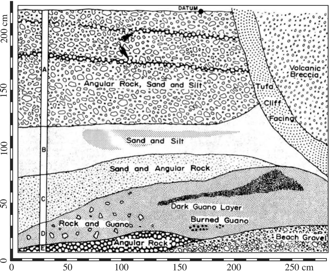
Figure 3. East profile of Trench B as depicted by and adapted from Byrne and colleagues (Reference Byrne, Roger and Heizer1979).
Heizer (Reference Heizer1951) reported his work a year later. He described three major stratigraphic units. From top to bottom they are (1) windblown dust mixed with woodrat midden debris and rockfall, (2) fine windblown dust mixed with tufa rockfall, and (3) dark brown and sometimes burned bat guano. In their subsequent report, Byrne and colleagues (Reference Byrne, Roger and Heizer1979) described two additional strata in Area B: (1) angular gravels underlying the guano layer; and (2) layers of whitish gray sand and silt underlying the upper windblown dust and packrat material layer. These brought the number of reported strata to five (labeled Units A–E from top to bottom; see Figure 3), plus a basal gravel layer to which they did not assign a letter. Stratigraphic Units A–D produced artifacts in varying quantities across the four excavation areas. Unit A produced coiled basketry and arrow fragments in Area D but nothing in Areas B or C. Unit B only produced artifacts in Area C. These included closed-twined basketry fragments, some of which were burned and associated with an infant burial. Unit D produced the tan chert biface, the obsidian biface fragment, the string of 50 shell beads and two other detached shell beads, the complete atlatl dart and greasewood foreshafts, and bits of cordage in Area B; and one obsidian flake in both Area C and Area D. Byrne and colleagues (Reference Byrne, Roger and Heizer1979) later analyzed pollen from sediment samples collected during the 1950 excavations, which proved to be challenging because unresolved questions about the contexts of the samples made it difficult to correlate them to Heizer's strata.
Heizer's (Reference Heizer1951; Byrne et al. Reference Byrne, Roger and Heizer1979) age estimations for stratigraphic Units A–E were guided by a handful of radiocarbon-dated organic artifacts and sediment samples (Table 1). According to Byrne and colleagues (Reference Byrne, Roger and Heizer1979), Lake Lahontan receded below the shelter for a final time prior to approximately 13,900 cal BP, leaving behind well-rounded gravels.Footnote 5 Following the lake's recession, angular roof fall (Unit E) and guano-rich sediment (Unit D) accumulated between approximately 13,900 and 8300 cal BP. Heizer did not obtain radiocarbon dates for any materials from the overlying fine sand and rock layer (Unit C). Based on a few radiocarbon-dated artifacts and its lithology, he assigned Unit B an age of roughly 7400–5150 cal BP. Although he did not date anything from Unit A, similarities between the basketry found within both LRS and deposits postdating 5150 cal BP in nearby Lovelock Cave led him to assign Unit A to the same period.
Table 1. Radiocarbon Dates from Leonard Rockshelter.

Note: Previously reported dates in shaded rows.
a PAHMA (2-x) and UNR (FS-x) ID numbers.
b Radiocarbon dates calibrated using OxCal online program (Bronk Ramsey Reference Bronk Ramsey2009) and IntCal20 curve (Reimer et al. Reference Reimer, Austin, Bard, Bayliss, Blackwell, Ramsey and Butzin2020), and rounded following Stuiver and Polach (Reference Stuiver and Polach1977).
c UNR strata designated by number, and UCB strata designated by letter. We assigned items in the PAHMA collection to Heizer's (Reference Heizer1951; Byrne et al. Reference Byrne, Roger and Heizer1979)
stratigraphic units using information contained in the museum's online database.
Heizer's (Reference Heizer1951) interpretations of site formation and use are historically significant because his work was one of the first times that researchers used radiocarbon dating to answer archaeological questions, but many of the dates on which he based his interpretations were obtained using methods that are now considered unreliable (e.g., combining multiple organic items to obtain a single date, dating bulk guano-rich sediment samples that may be susceptible to contamination from a variety of sources). His work was also important because it demonstrated that LRS contained a stratified cultural record that probably spanned the Holocene. For this reason, LRS was designated a National Historic Landmark in 1961. Though somewhat limited by uncertain provenience data, Byrne and colleagues’ (Reference Byrne, Roger and Heizer1979) subsequent pollen study was also important because it provided a picture of past environmental conditions in the Humboldt Sink at a time when such information was lacking. Hughes and Bennyhoff (Reference Hughes, Bennyhoff and D'Azevedo1986; see also Bennyhoff and Hughes Reference Bennyhoff and Hughes1987) included marine shell beads from LRS in their review of precontact trade networks and, more recently, Adams and colleagues (Reference Adams, Goebel, Graf, Smith, Camp, Briggs and Rhode2008) included Heizer's date on the combined foreshafts in their study of terminal Pleistocene and early Holocene lake levels and site location in the Lahontan Basin. Apart from these studies, most of which took place decades ago, LRS has largely faded into obscurity. Some more senior Great Basin scholars might recall why the site was designated a National Historic Landmark or what Heizer recovered from it, but many junior scholars likely know only the site's name, if that. In the remainder of this article, we outline our return to LRS to reengage readers with the site and address the 70-year-old question of whether it contains evidence of human use dating to Clovis or pre-Clovis times.
UNR's Return to Leonard Rockshelter
Fieldwork: Testing and Stratigraphic Interpretations
To minimize further disturbance to any remaining intact deposits and maximize our chances of replicating Heizer's (Reference Heizer1951) results, we sought to relocate the Area B excavation block, expose the eastern wall on which Byrne and colleagues’ (Reference Byrne, Roger and Heizer1979) stratigraphic profile is based, and excavate a 1 × 1 m test pit into intact deposits. Time is not kind to previously excavated sites and if left unprotected, vertical profiles can quickly become slumped messes. Illegal excavations by looters, who sometimes excavate after professionals’ work is done, can further confound attempts to relocate a site's datum, excavation sidewalls, or other reference points. Both processes occurred following the end of Heizer's fieldwork, and only a rough outline of the Area B excavation block was discernable.
Prior to excavating in 2018, we established a grid system using a datum set at an arbitrary point (500 m N, 500 m E, and 100 m elevation) near Heizer's Area B excavation block. We used a total station to tie the site datum to a USGS turning point located at 1,201.2 m asl on the gravel road below LRS shown on the 2018 USGS 1:24k Wildhorse Pass Quadrangle Map. The ground surface where we placed our site datum sits at 1,285.0 m asl, roughly 84 m above the valley floor. Guided by Byrne and colleagues’ (Reference Byrne, Roger and Heizer1979) planview map (see Figure 2) and photographs of the Area B excavation block housed at UCB's Bancroft Library—and with a healthy dose of luck—we placed our first 1 × 1 m test pit (N495 E500) so that it almost perfectly crosscut Area B's intact eastern sidewall. In planview, the unit contained clearly distinguishable intact deposits (the balk that the UCB crew left between trenches B and C) and mixed backfill and/or wall collapse (see Figure 2 inset). This distinction between intact and mixed deposits in N495 E500 did not become visible until we had excavated approximately 60 cm below the current ground surface—meaning that the deposits to that depth in N495 E500 were wholly mixed. Subsequent radiocarbon dating of materials from those levels confirmed that fact (see Table 1).
We concurrently excavated a second 1 × 1 m test pit (N498 E497) a few meters northwest of N495 E500 and closer to the shelter's dripline to ensure that we recorded a representative sample of the Area B stratigraphy. The upper deposits proved to be disturbed, and they probably mark where the UCB crew dumped their excavated sediments. The lower deposits were intact and contained a thin band of Mazama tephra, but they were devoid of artifacts and difficult to correlate with the strata in N495 E500. For those reasons, we do not discuss them further here (for additional information about N498 E497 and the small-mammal record from LRS, see Sturtz Reference Sturtz2020).
Because we did not encounter artifacts in the lowest strata in N495 E500 (or any artifacts in primary contexts in that test pit, for that matter), and therefore could not replicate Heizer's findings, we returned in 2019 and excavated a third 1 × 1 m test pit (N494 E500) adjacent to N495 E500. Like N495 E500, N494 E500 crosscut Heizer's Area B east sidewall and was therefore a combination of mixed and intact deposits. The east profile of our contiguous N494 E500 and N495 E500 test pits and the south profile of our N495 E500 test pit provide a good representation of the strata that we encountered (Figure 4). Whereas Byrne and colleagues (Reference Byrne, Roger and Heizer1979) describe five major stratigraphic units in the vicinity of our test pits, we delineated nine (Table 2). We know that Heizer's Stratum E corresponds to our Strata 8 and 8a. We also know that our Stratum 1, which comprised the upper approximately 60 cm of deposits through which we excavated in N494 E500 and N495 E500, represents mixed fill. Beyond those correspondences, we are less confident in correlating the layers we recorded with those reported by Heizer and colleagues (Byrne et al. Reference Byrne, Roger and Heizer1979; Heizer Reference Heizer1951). Our Strata 2, 3, and 3a may represent their Unit B (sand and silt), our Strata 3b and 4 may represent their Unit C (sand and angular rock), and our Strata 5–7 may represent their Unit D (rock and bat guano). These correlations should be considered tentative at this point, but as we explain below, this uncertainty in tying our fine-grained strata to their coarse-grained strata does not weaken our primary conclusions. Because we excavated just 3 m2 within a small area, we do not know how representative our stratigraphic interpretations are for the entire site, but based on clear differences between Heizer's interpretations (which he applied to all excavation areas) and our own, LRS's stratigraphy is probably both vertically and laterally more complex than he described.

Figure 4. Stratigraphic profiles for N494 E500 and N495 E500 in Heizer's Area B excavation block. (Color online)
Table 2. Possible Relationships between UCB and UNR Stratigraphic Designations in Heizer's Area B Excavation Block.

a As reported by Heizer (Reference Heizer1951; Byrne et al. Reference Byrne, Roger and Heizer1979).
Our 2018 and 2019 test pits produced a handful of artifacts mostly from the upper levels that we now know were mixed. Precontact artifacts include nine Olivella biplicata beads (eight A1a small simple spire-lopped and one A1b medium simple spire-lopped [Bennyhoff and Hughes Reference Bennyhoff and Hughes1987]), a small piece of cordage, and six tiny flakes. Postcontact artifacts include three shell casings, a piece of metal wire, and one piece of degraded fabric. Near the bottom of the infilled Area B excavation block, we found two additional pieces of degraded fabric and a camera flashbulb. The fabric, which we only identified as being non-Indigenous and commercially produced (probably burlap left behind by the UCB crew) through microscopic analysisFootnote 6, and flashbulb are significant because they helped to confirm that portions of the deposits in N494 E500 and N495 E500 were mixed.
We encountered a few tiny flakes in undisturbed deposits along the Strata 2/3 contact (n = 2) and Strata 3b/4 contact (n = 1) in N494 E500, and within Stratum 7 in N495 E500 (n = 1). We also recorded a heavily reworked biface made of obsidian from the Bordwell Spring/Pinto Peak/Fox Mountain source group, located approximately 180 km northwest of LRS, at an elevation of 98.44 m in Stratum 8 in N494 E500 (Figure 5).Footnote 7 A piece of charcoal recovered in situ from N495 E500 at an elevation of 98.18 m—135 cm north of the biface and 26 cm below it, but at approximately the same depth within Stratum 8 because the deposits slope downward from south to north—returned a date of 9835 ± 45 14C BP (11,390–11,185 cal BP). That charcoal date provides an approximate age for the biface. A piece of vegetation found at an elevation of 98.45 m in the overlying Stratum 6 in N495 E500 returned a date of 8410 ± 45 14C BP (9530–9300 cal BP) and provides an upper limiting age for the biface. The biface and dated samples are significant because they establish that people visited LRS during the earliest Holocene. As we describe below, the dated charcoal is also important because it provides an upper limiting age for the underlying beach gravels (Stratum 9).
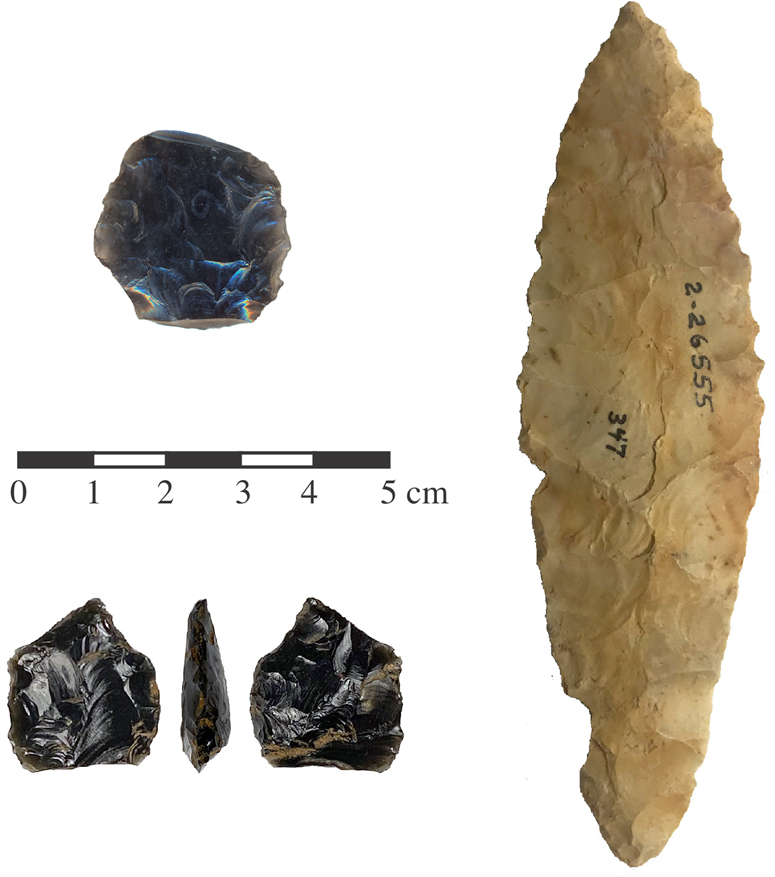
Figure 5. Bifacial tools from Area B in Leonard Rockshelter. Upper left: 1-50603, a reworked obsidian biface recovered by Heizer in Unit D (guano layer). Lower left: FS-72, a reworked obsidian biface recovered by UNR in Stratum 8, test pit N494 E500. Right: 2-26555, a chert biface recovered by Heizer in Unit D (guano layer). (Color online)
Directly Dating Artifacts to Establish When People Visited the Site
Heizer collected 500+ artifacts during his work at LRS, and these are currently housed in the Phoebe A. Hearst Museum of Anthropology (PAHMA) at UCB. These include basketry and cordage, wooden foreshafts, a few obsidian and chert tools, Olivella beads, and worked wood. Less than 20% of the collection might be considered everyday detritus—things such as flakes and animal bones—and we rarely encountered such artifacts during our excavations or noted them in Heizer's backdirt. As an independent means of assessing the possibility that people visited LRS during the late Pleistocene, we sampled 12 organic artifacts in the PAHMA collection for AMS radiocarbon dating. These include basket, cradleboard, mat, sandal, and cordage fragments, as well as the complete atlatl dart and a winnowing tray (see Table 1). We primarily selected items that had some contextual data—for example, an excavation area and/or stratum. We favored items from Unit D (the guano layer) in Area B, where Heizer found the most compelling evidence of early human use and obtained a Pleistocene date on the bat guano. Finally, we sampled a few of the rarer items, including the atlatl dart from the guano layer and a winnowing tray from the surface. Whenever possible, we used detached bits of these artifacts from the containers in which they are stored.
Table 1 lists the radiocarbon dates we obtained on these artifacts. They range in age from 9475–9275 to 430–150 cal BP. Although they constitute a small sample, these radiocarbon dates tell us two things about when people visited the site. First, they do not support the hypothesis that people visited the site during the late Pleistocene. Rather, people probably first visited the site during the earliest Holocene—a scenario supported by the reworked obsidian biface associated with the charcoal dated to 11,390–11,185 cal BP in Stratum 8. Second, the dated artifacts span nine millennia, indicating that people periodically returned to LRS throughout the Holocene, including just before Euro-Americans arrived in western Nevada. It is important to note that although the ages of these dated artifacts reflect times when people visited the site, the gaps between those age ranges do not necessarily reflect periods of disuse, because they may simply be a function of the small number of dated items (Rhode et al. Reference Rhode, Jeffrey Brantingham, Perreault and Madsen2014).
Discussion
Heizer's (Reference Heizer1951) claim of a late Pleistocene occupation coeval with or earlier than the Clovis Era drew us to LRS. Our goal was to evaluate this claim and better understand the history of human use of the shelter. In many ways, revisiting old sites is more challenging than excavating new ones because there is the added difficulty of deciphering what previous researchers did and where they did it. Our major travails were determining whether the upper levels of our test pits comprised intact or mixed deposits (they were mixed) and finding clear evidence of human activity in the lower levels (we did). Despite these challenges, we learned three important things about site formation processes and human history at LRS.
First, coupled with a refined understanding of Lake Lahontan's late Pleistocene history (Adams and Wesnousky Reference Adams and Wesnousky1998; Adams et al. Reference Adams, Goebel, Graf, Smith, Camp, Briggs and Rhode2008), our work provides clarity about both when LRS was first available for occupation and when people likely first occupied it. Regarding when LRS was first available for occupation, the elevation of the ground surface in Area B is 1,285.0 m. The upper boundary of the beach gravel layer, which lies approximately 1.5 m below the ground surface, is 1,283.5 m asl. The last time Lake Lahontan reached that elevation was just before 15,000 cal BP, during its post–Sehoo highstand recession (Figure 6). Consequently, LRS was first available for occupation around 15,000 cal BP.

Figure 6. The relationship between the lake-level curve for the Carson-Humboldt sinks of Lake Lahontan (blue line) and the elevation of Leonard Rockshelter (red line). Leonard Rockshelter was inundated by the lake around 17,000–15,000 cal BP during its Sehoo highstand (gray area). As the lake transgressed, the shelter became available for human occupation around 15,000 cal BP. Lake-level curve adapted from Adams and colleagues (Reference Adams, Goebel, Graf, Smith, Camp, Briggs and Rhode2008; Adams and Rhodes Reference Adams and Rhodes2019). (Color online)
With respect to when people first occupied the site, drawing on Heizer's (Reference Heizer1938, Reference Heizer1951) work and citing his date of 11,120 ± 570 14C BP (14,940–11,620 cal BP) on guano-rich sediment from near the bottom of stratigraphic Unit D, Byrne and colleagues (Reference Byrne, Roger and Heizer1979:284) concluded that “the guano . . . can be taken as marking the beginning of the period during which the shelter was open for human occupation. It was apparently soon occupied because obsidian flakes were recovered from the base of the guano layer in Areas B and C.” Heizer's date of 11,120 ± 570 14C BP (14,940–11,620 cal BP) on guano-rich sediment from the bottom of stratigraphic Unit D is problematic due to its very large error and the fact that is was derived from a bulk sediment sample that could be contaminated by a variety of older (e.g., carbonates) and younger (e.g., humates) sources. It is also discordant with our AMS date of 9835 ± 45 14C BP (11,390–11,185 cal BP), obtained on a charcoal fragment from Stratum 8 (probably Heizer's stratigraphic Unit E); our AMS date of 7020 ± 25 14C BP (7935–7790 cal BP), obtained on the complete atlatl dart recovered from stratigraphic Unit D; and Heizer's date of 7040 ± 350 14C BP (8600–7180 cal BP), obtained on the greasewood foreshafts recovered from the upper part of stratigraphic Unit D.
Together, these facts strongly suggest that the shelter's basal terrestrial deposits—Heizer's stratigraphic Units D and E and our Stratum 8—date not to the latest Pleistocene but rather the initial early Holocene, probably around 11,500 cal BP. If we are correct in this assertion, then LRS experienced a roughly 3,500-year period during which minimal terrestrial sediment accumulated inside the shelter. This is not surprising because the site appears to lack a significant uphill source from which sediment at the site could be derived, and soil development on similar-age beach features in the Lahontan Basin is usually limited to the addition of eolian dust to the coarse gravel (Adams and Wesnousky Reference Adams and Wesnousky1999). Consequently, although we replicated Heizer's discovery of artifacts near the bottom of the terrestrial deposits overlying the lake gravels, we believe that people left them behind during the early Holocene and not the late Pleistocene.
It is important to note that because neither Heizer's nor our own team penetrated the recessional lake gravels, we cannot rule out the possibility that people visited LRS prior to Lake Lahontan's Sehoo highstand. The question of whether humans were present in North America at that time remains debated among Western scientists, although a handful of sites suggests that it may have been the case (Davis et al. Reference Davis, Madsen, Becarra-Valdivia, Higham, Sisson, Skinner and Stueber2019; Waters Reference Waters2019; Williams and Madsen Reference Williams and Madsen2020). If people were present in the Lahontan Basin prior to the lake's Sehoo highstand, then LRS would have been available for occupation before approximately 17,000 cal BP but not between roughly 17,000 and 15,000 cal BP, when the shelter was submerged (Reheis et al. Reference Reheis, Adams, Oviatt and Bacon2014). Any traces of pre–Sehoo highstand visits are unlikely to have survived because the shelter was underwater for two millennia or so (see Figure 6) before it filled with gravels transported and deposited in a high-energy wave environment as the lake waters receded below the elevation of the shelter.
Second, although people did not stay in LRS for extended periods, they did leave behind items at various times during the Holocene. The association of the reworked obsidian biface and dated charcoal indicate that these visits began 11,390–11,185 cal BP. Four other radiocarbon-dated sites in the Lahontan Basin—Spirit Cave, the Wallman Bison, Shinners Site A, and Pyramid Lake—confirm a human presence in the area at that time (Adams et al. Reference Adams, Goebel, Graf, Smith, Camp, Briggs and Rhode2008; Smith and Barker Reference Smith and Barker2017). Other open-air lithic scatters containing Western Stemmed Tradition (WST) and/or concave base points in the Lahontan Basin may also date to around that time, although it is difficult to know because they have not been radiocarbon dated.
People certainly visited the site again during the initial middle Holocene between approximately 8300 and about 7800 cal BP, during which time they left behind bits of cordage, a complete atlatl dart, and three dart foreshafts. The dart, which is tipped with a sharpened greasewood foreshaft that was not designed to accommodate a stone point (Heizer Reference Heizer1938), and the dated greasewood dart foreshafts were both found in Area B. The narrow age range of the dart falls within the broader age range of the foreshafts. These items may represent a hunter's gear stored for later retrieval and, to our knowledge, they represent the oldest directly dated dart / dart components in the Great Basin. Unfortunately, the dart cannot speak directly to questions about the weapon delivery system(s) used by WST hunters because it postdates the end of the WST in the western Great Basin by 1,100–1,200 years (Rosencrance Reference Rosencrance2019). The dart also cannot speak to questions about the possible co-emergence of atlatls and notched projectile points because it is not tipped with a stone point. A second period of use during the middle Holocene is indicated by burned basketry that Heizer dated to 7400–5750 cal BP. Although there was likely a brief wet period around 7680 cal BP immediately prior to that interval (Davis Reference Davis, Madsen and O'Connell1982), much of the middle Holocene was relatively arid. Locally, the Humboldt River ceased flowing at times (Miller et al. Reference Miller, Kyle House, Germanoski, Tausch, Chambers, Chambers and Miller2004), and the Humboldt Sink was generally dry (Byrne et al. Reference Byrne, Roger and Heizer1979).
Four or five late Holocene periods of use are reflected by dates on a sandal fragment, cradleboard fragments, matting, and basketry. People visited at approximately 2900 cal BP, about the same time that people started to occupy the nearby Humboldt Lakebed Site (26Ch15)—a large residential site containing dozens of house features (Livingston Reference Livingston1986)—as well as Lovelock Cave (Heizer and Napton Reference Heizer and Napton1970). There is a gap in use of LRS between approximately 2850 and 2000 cal BP that corresponds closely to the Late Holocene Dry Period (LHDP; Mensing et al. Reference Mensing, Sharpe, Tunno, Sada, Thomas, Starratt and Smith2013), but more direct dating of organic artifacts is needed to demonstrate whether the gap is real and perhaps related to a climatic event or simply a function of our small sample of dated items. Interestingly, there were at least two relatively wet periods within the LHDP, because large lakes appeared in the Humboldt Sink (Adams and Rhodes Reference Adams and Rhodes2019). Other visits occurred between approximately 2000 and approximately 1500 cal BP, and then they appear to have stopped until 430 cal BP or later, during which time someone left behind a worn winnowing tray. Again, although it may simply be a function of the small sample of dated items, it is worth noting that the gap between 1550 and 430 cal BP corresponds to a time when—based on house form, projectile point frequencies, and radiocarbon dates—the Humboldt Lakebed Site saw heavy use (Livingston Reference Livingston1986). This peak in occupation of the Humboldt Lakebed Site is part of a broader pattern of intensive Late Archaic use of the Humboldt Sink (Sturtz Reference Sturtz2020) that did not include either Leonard Rockshelter or Lovelock Cave to the same degree.Footnote 8 Within this period of occupation, however, the Humboldt Lakebed Site (~1,188 m asl) was inundated by at least three brief lake-level rises, including the Medieval pluvial lake that reached an elevation of approximately 1,202 m asl around 830 cal BP (Adams and Rhodes Reference Adams and Rhodes2019). In contrast, the Medieval pluvial lake was both preceded and followed by severe, multidecadal droughts (Cook et al. Reference Cook, Richard Seager, Heim, Vose, Herweijer and Woodhouse2010) that likely left the Humboldt Sink dry.
Third, although we excavated only a tiny portion of the site's remaining intact deposits, we found no evidence that people spent significant amounts of time in LRS. Food residues and food processing implements, lithic detritus, and other signs of daily life were generally absent in excavated intact deposits. They were similarly scarce in Heizer's backdirt (either on its surface or in portions that we excavated) and the PAHMA collection. This absence of everyday debris suggests that people mostly used LRS as a place to store gear rather than live. This is not surprising given the site's location. It is north facing and perched on the side of a steep slope, approximately 84 m above the valley floor. There are no freshwater springs nearby. During wet periods when the Humboldt Sink held lakes and/or marshes, people probably gravitated to them rather than the dry rocky slope on which LRS sits. This was certainly the case during the late Holocene, when people established residential sites along the lake's margins (Livingston Reference Livingston1986). Although more dating is certainly needed, there is currently no evidence that the intensity of people's use of LRS rose and fell directly in concert with the intensity of use at those settlements.
Conclusions
Stratified and well-preserved records of human behavior found in dry caves and rockshelters anchor our understanding of chronology, subsistence, and perishable technology in the Great Basin. Professional researchers and pothunters alike have recognized this fact for more than a century, and as a result, most if not all significant cave or shelters have been excavated. Many previously excavated sites retain potential to provide additional information. Unresolved questions about the antiquity of human use led us back to LRS 70 years after Robert Heizer stopped working there. Heizer's limited reporting suggested that LRS might contain a pre-Clovis or Clovis Era occupation, either of which would be significant because evidence for human use during those periods is rare in western Nevada. Our work failed to replicate his findings and suggests that people first visited LRS during the early Holocene. Throughout the Holocene, people periodically visited LRS, but they do not appear to have spent much time there. Instead, they stored a range of personal gear in a manner that is somewhat consistent with other caves and shelters in the Carson and Humboldt Sinks. People's use of the shelter waxed and waned, but not necessarily in tandem with broader land-use patterns in the region.
Acknowledgments
Leonard Rockshelter is located on the traditional lands of the Lovelock Paiute Tribe. It is currently owned by the Archaeological Conservancy. Cory Wilkins (Archaeological Conservancy) facilitated our fieldwork, which was conducted by UNR graduate students Nicole George, Denay Grund, Derek Reaux, Richie Rosencrance, and Sara Sturtz, and supported by Millie and Gavin Smith. Anna Camp, Pat Barker, and Eugene Hattori (Nevada State Museum), Catherine Fowler (UNR Anthropology Department), and Tom Connolly (University of Oregon Museum of Natural and Cultural History) guided the macroscopic analysis of the textiles recovered during our fieldwork, which ultimately led us to collaborate with Elizabeth Kallenbach. Pat Barker and members of the Northwestern Great Basin Textile Dating Project provided several unpublished dates on artifacts from Lovelock Cave (please contact Pat at barkerj@unr.edu for more information). Natasha Johnson (University of California, Berkeley) facilitated our study of the LRS collection housed in the PAHMA. The UCB granted us access to Heizer's photographs and fieldnotes. Comments from David Hurst Thomas and three anonymous reviewers helped us add clarity to the final version of the manuscript. Finally, Hector Urtubia provided the Spanish abstract, for which we are grateful. Unless otherwise noted, all figures are by the authors.
Data Availability Statement
The artifact assemblage, photographs, and fieldnotes related to Robert Heizer's work at LRS are housed at the University of California, Berkeley. The artifact assemblage, photographs, and fieldnotes related to UNR's work at LRS are housed at the University of Nevada, Reno's Department of Anthropology and Anthropology Museum.
Competing Interests
The authors declare none.


 Open access