


What is El Pozito? Currently, it is a field of sugarcane. More precisely, the site known as “El Pozito” is a set of tumbled mounds spread across and beneath a mix of farmland and scattered trees in Northern Belize. The remains, such as they are, lie in the Orange Walk District, 5 km outside the village of Guinea Grass, north of the road leading to August Pine. Not much remains above the surface. The various pyramids and platforms have largely melted into the ground, leaving little more than an especially lumpy part of the local landscape. El Pozito receives no tourists and few visitors of any kind. It rarely appears on maps and, when it does, it is often misplaced. Sometimes it is spelled “El Posito.” In her comprehensive tourist's guide to Northern Belize, Vivien Lougheed (Reference Lougheed2010) gives it small mention, noting that there is little to see. El Pozito is, she writes, “little more than a mound.”
The neglect of El Pozito is strange, given that it sits in one of the most heavily studied subregions of the Maya world (see Robin Reference Robin2020). It is surrounded by numerous, well-known major sites and research projects (Figures 1 and 2). To the north are Cuello and Nohmul, both intensively investigated by Norman Hammond in the 1970s and 1980s (Hammond Reference Hammond1985; Hammond Reference Hammond1991). Farther downriver are Santa Rita Corozal, studied by Diane and Arlen Chase (Chase Reference Chase1981, Reference Chase1982; Chase and Chase Reference Chase and Chase1988), and Aventura, presently under study by Cynthia Robin (Robin et al. Reference Robin, Kosakowsky, Grauer, Nissen and Jones2017, Reference Robin, Kosakowsky, Grauer, Nissen and Fitzgerald2019). David Freidel and Robin Robertson famously explored Cerros in the late 1970s and 1980s (Robertson and Freidel Reference Robertson and Freidel1986; Walker Reference Walker and Walker2016). To the south and west are other significant, heavily documented sites. These include Lamanai, first investigated by David Pendergast in the 1970s (Pendergast Reference Pendergast1981), then by Elizabeth Graham and associates in the 2000s (Graham Reference Graham, Awe, Morris and Jones2004, among others). Helen Haines (Reference Haines2011) and Kerry Sagebiel (Sagebiel and Haines Reference Sagebiel and Haines2018) continue their study of the nearby site of Ka'Kabish (McLellan and Haines Reference McLellan and Haines2013). Farther to the west, teams led by Thomas Guderjan (Reference Guderjan2007, Reference Guderjan2013, Reference Guderjan2016) have examined the Blue Creek area for more than two decades. To the east lies the famous site of Altun Ha, also studied by David Pendergast (Reference Pendergast1979, Reference Pendergast1982, Reference Pendergast1990), and the important site of Colha, where Thomas Hester and Harry Shafer brought to light major chert workshops (Hester et al. Reference Hester, Eaton and Shafer1980, Reference Hester, Eaton, Shafer and Adams1982). Marilyn Masson (Reference Masson2000, Reference Masson, Masson and Freidel2002) investigated the nearby rural community of Laguna de On. This is just a sampling of the some of the better-known sites in the area—one that omits a dozen other studies, surveys, sampling programs, small-scale excavations, or regional perspectives (Robin Reference Robin2020). These investigations have changed our basic understanding of the Maya past and illuminated a remarkable regional history. But not so El Pozito.

Figure 1. Map of the Maya World (by Eppich).
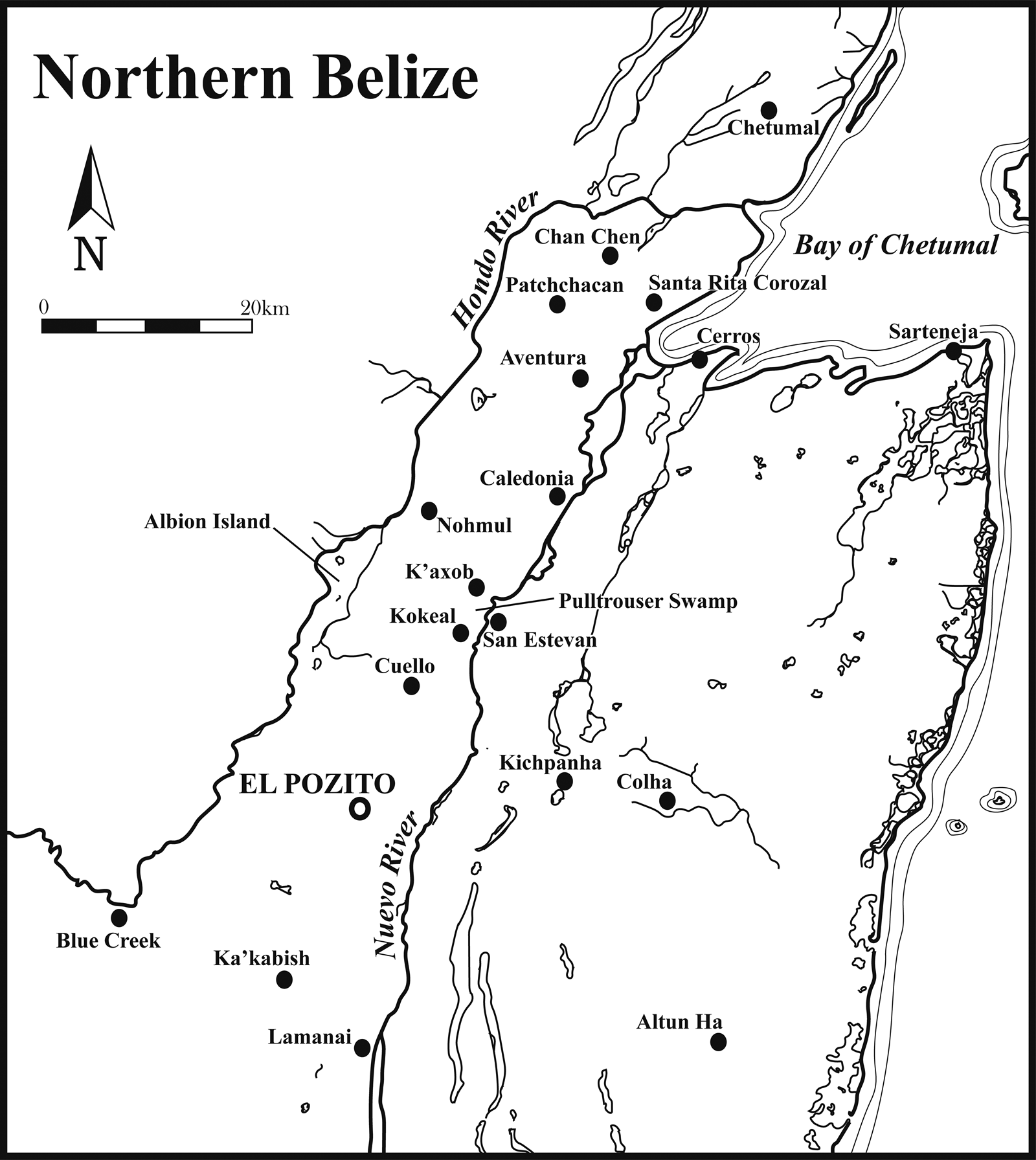
Figure 2. Map of major archaeological sites in Northern Belize (by Eppich).
For decades, the site remained a curious blank spot on the map, a “little hole” in our understanding of regional antiquity. This article represents an effort to change that. It is an attempt to explain the settlement and its place within the broader framework of Classic Maya civilization, a.d. 250–1000. To the extent possible, this contribution examines the occupational, economic, social, political, and regional context of the site. It draws together the scattered research on El Pozito, including unpublished field notes and illustrations, the few previous publications, mentions in third-party books and articles, and analyses of material culture undertaken years after excavation. Not intended to be a comprehensive or final report, it simply aims at answering the basic question, “What was El Pozito?” The answer that emerged placed El Pozito on the lower end of a hierarchy of urban development, a settlement that combined aspects of urban functionality on a landscape of rural complexity. This article argues that El Pozito was a Classic Maya town. It is through this theoretical framework—the idea of the “town”—that El Pozito's socioeconomic and political history and transformations can best be understood, especially as reflected in the ceramic evidence and construction history recovered from the site.
Towns: concept, settlement form, and the Classic Maya urban tradition
Mayanist scholars have well documented the presence of large urban centers in the Classic Maya world (Chase et al. Reference Chase, Chase and Haviland1990; Smith Reference Smith1989, Reference Smith2011). Such cities consisted of sprawling, low-density habitation with distinct communities interspersed with reservoirs, canals, roadways, cornfields, garden plots, curated woodlands, fallow forests, swampy wetlands, and wholly wild rainforests (e.g., Fedick Reference Fedick1996; Fisher Reference Fisher2014; Fletcher Reference Fletcher and Smith2012; Isendahl Reference Isendahl2012; Isendahl and Smith Reference Isendahl and Smith2013; Lentz et al. Reference Lentz, Magee, Weaver, Jones, Tankersley, Hood, Islebe, Ramos, Dunning, Lentz and Scarborough2015; Marken Reference Marken2011; Marken and Murtha Reference Marken and Murtha2017; Smith Reference Smith2011). At the center of this conurbation lay the urban core, usually a dense collection of residential compounds, palaces, public areas, and ritual-regal architecture. The Classic Maya urban tradition did not generally produce heavily nucleated centers; instead, it dispersed “Garden-cities” (Chase and Chase Reference Chase and Chase1998; Graham Reference Graham, Bacus and Lucero1999; Sabloff and Tourtellot Reference Sabloff and Tourtellot1991; Tourtellot and Sabloff Reference Tourtellot, Sabloff and Prem1994). Such a low-density urban settlement pattern was uniquely adapted to life in the delicate environments of subtropical forests, spreading out the impact of human usage across a wide area (Awe et al. Reference Awe, Hoggart and Helmke2014; Chase and Chase Reference Chase and Chase2017; Eppich Reference Eppich, Cherry and Rojas2015; Isendahl and Smith Reference Isendahl and Smith2013; Peuramaki-Brown Reference Peuramaki-Brown2014). These patterns led to a proliferation of such cities during the Classic Maya period, with 40 or 50 urban entities scattered across the Maya Lowlands between a.d. 250 and 1000 (Demarest Reference Demarest2004; Martin Reference Martin2020; Martin and Grube Reference Martin and Grube2008; McKillop Reference McKillop2004). Understanding the Classic Maya urban tradition requires a theoretical shift in how to think about cities (Eppich et al. Reference Eppich, Marken, Menéndez, Marken and Arnauld2023; Marken and Arnauld Reference Marken and Charlotte Arnauld2023). Urban settlement should not be approached solely in terms of population density, or on the scale of monumental architecture, or even in fulfilling a checklist of requirements (see Childe Reference Childe1950). Urban settlements—cities—are themselves a type of artifact. They should not be thought of as sui generis phenomena, but as solutions to specific types of problems (Houk Reference Houk2015; see also M. L. Smith Reference Smith2003, Reference Smith2019). Cities formed because they served a variety of functions. As these functions changed over time, cities themselves changed. A functional definition of “urbanism” is one that examines what functions the city-artifact served and what problems urban settlement attempted to solve. Such functions included, but were not limited to, cities serving as (1) regal-ritual centers housing a sacred royal court, (2) administrative centers that dispensed political power, (3) the foci of economic and commercial activities, (4) places that extracted and distributed resources on a regional level, (5) religious centers that contained and manifested sacred ideologies, and (6) sources of military protection and security on an insecure landscape (Fox Reference Fox1977; Masson and Freidel Reference Masson, Freidel, Hirth and Pillsbury2013; Sanders and Webster Reference Sanders and Webster1988; M. L. Smith Reference Smith2019; Stanish Reference Stanish, Garraty and Stark2010). The importance and scale of each aspect of urban functionality seem to have determined the type of city that was manifested, and perhaps even the size and density of the urban settlement itself.
Yet, these distinct functions did not necessarily require huge conurbations of human settlement, even when they were needed at all. Such political, religious, economic, and military functionality could be spread across a wider landscape in a pattern of “rural complexity” (Iannone and Connell, ed. Reference Iannone, Connell, Iannone and Connell2003; Scarborough et al. Reference Scarborough, Valdez and Dunning2003; see also Lamb Reference Lamb, Hutson and Ardren2020, Reference Lamb2022a; Lemonnier and Arnauld Reference Lemonnier and Arnauld2022; Robin Reference Robin2012). There, settlements possessed various characteristics and served different functions along a continuum of variation (Ashmore Reference Ashmore, Iannone and Connell2003; Iannone and Connell Reference Iannone, Connell, Iannone and Connell2003). Instead of an urban core and a rural hinterland, there existed structured landscapes of resource-specialized communities—different rural communities fulfilling different functions (Scarborough and Valdez Reference Scarborough, Valdez, Scarborough, Valdez and Dunning2003). Nested within such rural complexity were “middle-level settlements” at the top of local settlement hierarchies (Connell Reference Connell2000, Reference Connell, Iannone and Connell2003; Iannone and Connell Reference Iannone, Connell, Iannone and Connell2003). Such important nodes combined two or more aspects of the functionality described above, nucleating small populations and forming the most basic of urban forms. Middle-level settlements were at the top of local, rural hierarchies, yet they are the most basic types of urban settlement. To put it simply, these are towns: minor population centers supplying critical types of urban functionality on a landscape of rural complexity.
The town as a socioeconomic settlement type
There exists a broad and rich literature on the archaeology of towns, particularly in European settings (Astill Reference Astill1985; Christie and Loseby Reference Christie and Loseby1996; Crabtree Reference Crabtree2018; Hodges Reference Hodges2000; Schofield and Vince Reference Schofield and Vince2003). Christopher Dyer (Reference Dyer2003) proposed a “bundle of criteria” to identify towns, describing them as small settlements with fewer than 2,000 inhabitants and with limited architecture (between 50 and 400 houses). That architecture manifests considerable diversity, reflecting the broad social structure of such towns. These settlements contained significant crafting activities, with workshops generally located around their edges. They held a marketplace, one that usually specialized in the goods of the immediate region. Towns also possessed small-scale civil, political, and religious functions, all serving the needs of the local region (see Crabtree Reference Crabtree2018). Schofield and Vince (Reference Schofield and Vince2003:31) framed them even more succinctly, describing the major parts of a medieval town as being “a marketplace, a church, [and] often a castle.”
Towns exist at the bottom of a hierarchy of urban form. They can develop either into new cities or from heavily decayed ones (Hodges Reference Hodges2000; Hodges and Hobley Reference Hodges and Hobley1988; Schofield and Vince Reference Schofield and Vince2003; Speed Reference Speed2014). In fact, there can be little to distinguish a large town from a small city. Key differences between towns and cities seem to lie primarily in the relationship with the surrounding countryside. Cities command a hinterland, with the surrounding countryside serving the needs of the urban settlement. They function principally as the economic, cultural, political, and religious center of a wide area. Towns possess a decidedly different relationship, serving the needs of the rural countryside around them. They do not seem to project much political or religious authority over a region. The most important function of a town appears to have been a commercial one (Hodges Reference Hodges2000; Schofield and Vince Reference Schofield and Vince2003:121; see also Verhulst Reference Verhulst2002). Towns held large markets and periodic fairs—places where local farmers could purchase manufactured goods, often made in the town's workshops. They also served as places where agricultural goods could be sold for shipment to even larger markets. Market towns functioned as the economic interface between local farmers and the much larger world. “Peasants,” Dyer (Reference Dyer, Davies and Galloway2012:46) writes, “produced for a market which included foodstuffs and raw materials for the largest towns, and they contributed indirectly to international trade. Peasant consumers, by buying the products of specialized town-based crafts, participated in long-distance commerce” (see Dyer Reference Dyer1996). He argues that the movement in foodstuffs from farm to town to city proved indispensable for Late Medieval cities, in what he termed the “Feeding the City Project” (Dyer Reference Dyer, Davies and Galloway2012:41; see also Murphy Reference Murphy, Davies and Galloway2012). In their broad survey of medieval towns, Schofield and Vince (Reference Schofield and Vince2003:151) noted that the “fortunes of a town often depended on the success of its merchant class,” with new towns developing from local market fairs. Richard Hodges (Reference Hodges2000) also notes that many towns in the post-Roman period formed around ephemeral, temporary markets. Later, these new market towns developed significant craft production and markets to serve local needs as well as to interface with growing webs of long-distance trade. It seems that although towns possessed important civic and religious roles, their focus was economic.
El Pozito, as proposed here, was one such town. The architectural, ceramic, and other archaeological data suggest limited urban functionality on a local scale, as well as far-flung interactions across widespread areas of the Classic world. El Pozito seems to have served as the interface between local Maya and the much larger world, and it likely participated in its own indigenous version of the “Feeding the City” project.
Previous investigations
El Pozito was the focus of archaeological investigation from 1974 to 1976 by a University of the Americas team led by Mary Neivens and Dennis Puleston. They mapped the site core, dividing it into six architectural complexes, and they placed excavations into four of these (Figure 3). After 1976, the project faltered and then ceased entirely, owing partly to the death of Puleston in 1978. No final excavation report was ever published, although a collection of highly detailed field notes remains extant (Neivens and Puleston Reference Neivens and Puleston1976a, Reference Neivens and Puleston1976b). This article includes information from those field notes, presented here for the first time. However, after so much time—almost five decades—many of the illustrations and most of the notes no longer possess clear attribution. It is impossible to know exactly who mapped or excavated where and what. Regrettably, the names of most of El Pozito's pioneering investigators have been lost from their endeavors.
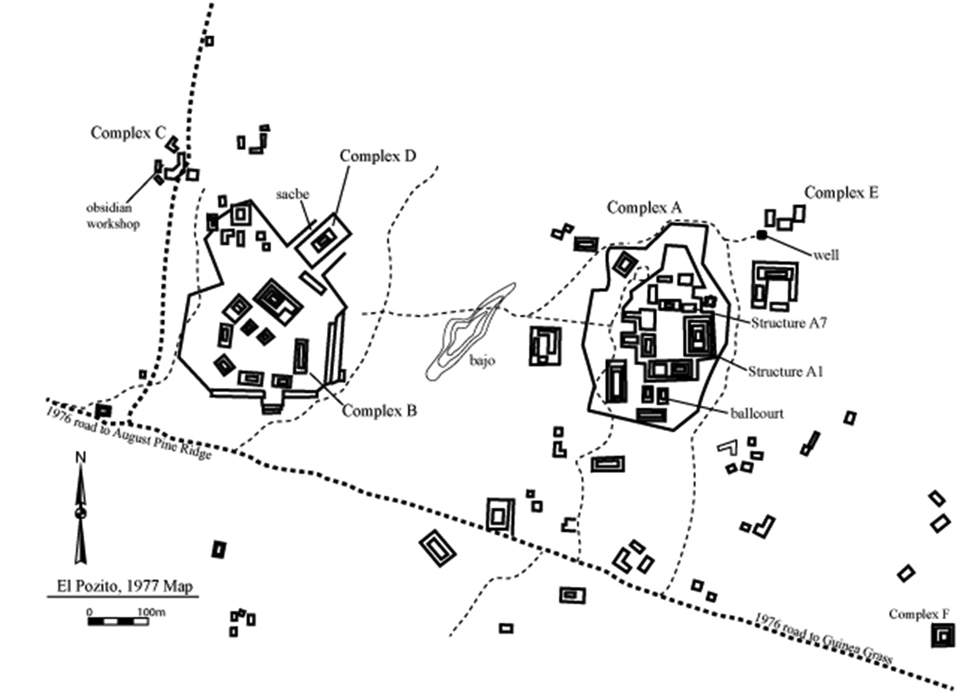
Figure 3. Map of El Pozito, based on a map from Neivens and Puleston (Reference Neivens and Puleston1976a).
Mary Neivens did publish on her work at El Pozito, documenting an obsidian workshop in the northwest corner of the site, recovering more than 12,082 obsidian artifacts (Neivens and Libbey Reference Neivens and Libbey1976; see also Neivens Reference Neivens1976). In a 1976 article, Raymond Sidrys described an Early Classic tomb in Complex A containing 4,500 pieces of obsidian and more than 40 expended cores. A 1985 exhibition catalog, The Maya: Treasures of an Ancient Civilization (Gallenkamp and Johnson Reference Gallenkamp and Johnson1985), featured a small gold bell, recovered from an intrusive Postclassic burial in Structure A1. Additional gold and copper artifacts are known from the site, although they have never been fully published.
Scholars continued to study the material culture from El Pozito well after the Neivens–Puleston project ended. Thomas Hester (Reference Hester, Shafer, Berry and Hester1991) and his colleagues documented the chert artifacts from the site, publishing a detailed lithic typology. They noted the presence of numerous tools from surrounding sites, including many from the famed chert workshops of Colha. Hester argued against local production, characterizing El Pozito as a consumer rather than a producer of chert tools. The ceramics of El Pozito continued to be studied over several decades. Duncan Pring (Reference Pring and Hammond1976a, Reference Pring1976b) focused on the Preclassic ceramics, placing them within the regional context of Northern Belize. Robert Case (Reference Case1982) documented the Protoclassic pottery in detail, using it in a pointed critique of the type-variety approach. The first full-scale ceramic typology for the site emerged at the start of the twenty-first century (Eppich Reference Eppich2000). Since that time, neither the site nor its material culture has received much attention. When the site is mentioned in the literature at all, authors merely cite but one or two of these earlier publications.
Physical description
The site of El Pozito is located between the Hondo and Nuevo Rivers, atop a rolling geological feature known as the San Pablo Ridge. The ridge is a distinct geomorphological feature, high and well drained, gently rising 30–40 m above the riverine floodplains flanking it. The ridge runs from the southwest to the northeast between the two rivers before ending at the Bay of Chetumal. The two rivers are wide and deep, navigable for much of their length. They possess swampy floodplains and often flood during the rainy season (Hammond Reference Hammond1985; Sidrys Reference Sidrys1983). Annual rainfall averages 132 cm, mostly falling from May to December.
Ecologically, the area once consisted of subtropical forest, midway between the multicanopied tropical forests of the Central Peten and the scrub forests of the Yucatan. Modern agriculture has mostly deforested the San Pablo Ridge, replacing the low forest with sugarcane—the principal crop of Northern Belize—although corn, potatoes, and soy are also common. A great part of the landscape has been converted into pasturage for large-scale commercial beef cattle.
The soil along the San Pablo Ridge is quite thin, often less than 40 cm in places, with high clay content. This is contrasted with the deep and fecund soils of the floodplain (Hammond Reference Hammond1985; Johnson Reference Johnson, Turner and Harrison1983; see also Fedick Reference Fedick1996). In antiquity, the Maya modified the land substantially, adding raised fields, canals, and terraces along the length of the ridge (Turner Reference Turner II, Turner II and Harrison1983; see also Beach et al. Reference Beach, Luzzadder-Beach, Krause, Guderjan, Valdez, Fernandez-Diaz, Eshleman and Doyle2019; Guderjan et al. Reference Guderjan, Luzzadder-Beach, Beach, Bozarth, Krause, Mathews and Guderjan2017; Guderjan et al. Reference Guderjan, Kwoka, Hanratty, Beach, Luzzadder-Beach, Krause, Eshleman, Ruhl and Doyle2019). Although it remains unknown exactly what the ancient Maya grew there, likely crops include corn, beans, squash, camotes, avocado, cacao, and possibly manioc (Bozarth Reference Bozarth and Guderjan2009; Guderjan et al. Reference Guderjan, Luzzadder-Beach, Beach, Bozarth, Krause, Mathews and Guderjan2017). The scale of the terrain modification argues for large-scale agriculture, far in excess of local requirements, and the implications of this are discussed below.
El Pozito's core covers roughly 1.5 km2 (Figure 3). At the very center of the site is a shallow depression, identified as a bajo on the Neivens and Puleston (Reference Neivens and Puleston1976a) map. It is likely a degraded reservoir or a heavily modified natural depression. Such modified or wholly artificial reservoirs are well- documented in the Maya region, particularly in the vicinity of dense settlement (French et al. Reference French, Straight and Hermitt2019; Marken and Cooper Reference Marken, Cooper, Pérez, Pérez and Freidel2018; Scarborough Reference Scarborough1998; Scarborough and Gallopin Reference Scarborough and Gallopin1991; Wahl et al. Reference Wahl, Schreiner, Byrne and Hansen2007).
Two large architectural complexes lie on either side of the bajo. To the east is Complex A, consisting of six to eight large structures atop a low, broad platform measuring approximately 200 x 200 m. Complex A is the largest architectural group at El Pozito and the site of the single largest building, Structure A1—a pyramid that stood 23 m tall in 1976 (Neivens and Libbey Reference Neivens1976). Excavation of the pyramid included clearing debris and collapse, placing test pits on the summit, and tunneling into the western face and southern side. The tunnels yielded several Early Classic tombs and caches within the pyramid, including one tomb with 4,500 obsidian blades. Sidrys (Reference Sidrys1983:11) also reported a Late Classic tomb from Structure A1, which held 4,992 obsidian artifacts, mostly blades. Thomas Hester and colleagues (Reference Hester, Shafer, Berry and Hester1991) noted that high-quality lithics came from these excavations, including chert eccentrics, macroblades, and lenticular bifaces, all typically associated with funerary contexts. Excavators also uncovered an intrusive burial at the summit, which included Postclassic ceramics and the gold bell mentioned earlier (Gallenkamp and Johnson Reference Gallenkamp and Johnson1985:223, Figure 196). The excavations along the base revealed that the foundations of Structure A1 are intrusive into the broad platform below it, the Maya having dug through the existing platform to place the pyramid's foundations directly on bedrock. Structure A1 remains the most visible portion of El Pozito today, its remnants being the low mound that failed to impress Vivien Lougheed in 2010.
The remainder of Complex A consists of a number of smaller pyramids on its southern and western sides and a cluster of range structures on the north. Neivens and Puleston carried out shallow excavations and test pits in several of the platforms, proposing a residential function. They also noted diagnostic Late Classic ceramics scattered across the surface. On the south side of the platform supporting Complex A, they mapped but did not excavate a standing ballcourt. Raymond Sidrys (Reference Sidrys1983:12) noted a long-vanished stela in front of Structure A7, describing it as short and plain and likely of Early Classic date.
Neivens and Puleston excavated a long, deep trench along the west side of the Complex A platform, digging down to bedrock (Figure 4). The trench indicated the presence of at least two Late Preclassic construction phases. They also documented buried architecture within the platform itself, indicating an earlier platform for Complex A. Just to the north of Structure A2, Neivens and Puleston documented a ceremonial hearth dating to the Postclassic, which was constructed directly on the platform flooring. Together with the intrusive burial at the summit of Structure A1 and the Postclassic votive material on its surface, this suggests continued ritual use of Complex A following widespread abandonment.

Figure 4. Excavations in Complex A plaza. Illustration by El Pozito Project, Mary Neivens (director).
They designated, as Complex B, a second large architectural complex to the west of the central aguada. Complex B consists of a single, broad platform measuring 300 x 250 m and standing 10 m above the rest of the site core. Nine structures formed a loose circle on the platform's southern end. The remains of an elevated causeway extend from the platform in a northeasterly direction. The terminus of the causeway is unknown. Complex D straddled the causeway just outside of its junction with Complex B. Neivens and Puleston carried out only limited probing of Group D and the underlying roadway. Complex C is a small patio group consisting of a few low mounds arranged in a rough rectangle just to the northwest. Neivens placed a single test pit there, recovering 12,082 obsidian artifacts from a 2 m2 unit (Neivens and Libbey Reference Neivens1976). The materials included cores and core fragments, rejuvenation flakes, blades, and blade fragments—everything that might be expected from an obsidian workshop.
At the northeast corner of the site is Complex E, the most thoroughly excavated location at El Pozito. The complex consists of two patio groups totaling seven structures arranged around the eponymous well for which the site was named. In 1974, the well measured 5.75 m deep. Neivens recorded large quantities of polychrome pottery from across the group and documented at least six burials. The recovered pottery is predominately Late and Early Classic, but one burial contained Late Postclassic ceramics—again, indicating usage of the site after general abandonment.
Complex F is on the southeast corner of the site core. This complex is a single structure and an adjacent chultun associated with a highly unusual feature. The structure itself is a small pyramid. Neivens noted that looters, apparently thinking that it was an intact tomb, ripped into the chultun. Once cleaned and excavated, however, it was revealed that the chultun opened into a series of three corbelled chambers, descending downward beneath the ground surface in a spiral pattern. Fifteen separate operations revealed a complex, spiral chultun—described as a “labyrinth” in the field notes—carved into the limestone bedrock. Such features are known in the region, having also been documented at the nearby site of Nohmul (Hammond Reference Hammond1985:85). Above-ground versions were documented at Yaxchilan (Tate Reference Tate1992), Tikal (Orrego Corzo and Larios Villalta Reference Orrego Corzo and Larios Villalta1983), and Oxkintok (Andrews Reference Andrews1993). The Maya likely fashioned these unusual “labyrinth” features to serve as artificial caves, an interpretation supported at El Pozito by the large amounts of associated votive materials. Excavators recovered substantial numbers of ceramics, the pottery ranging in date from the Late Preclassic to the Postclassic. This included many polychrome and censer fragments. The Postclassic sherds suggest that the spiral chultun, like Complex E and Structure A1, remained in use after much of the core itself had been abandoned.
Archaeologists also took extensive notes on the abundant ceramic sherds liberally scattered across the surface of the site, and Neivens noted that they were almost entirely of Late Classic date. For this reason, they likely represent the final stage of significant occupation for the site, although some portions—such as Complex E—might have remained in use long afterward.
The ceramics of El Pozito
In the late 1990s, the senior author was tasked with the documentation and analysis of the extant ceramic collections from El Pozito (Eppich Reference Eppich2000). The study described the ceramic types of the settlement, detailed its ceramic sequence, and attempted to determine the material relationships between El Pozito and its neighbors as reflected in the ceramic corpus (Eppich Reference Eppich2000). The ceramics were sorted and described using the type-variety method—which has long been the accepted standard for ceramic analysis in the Maya Lowlands (Aimers Reference Aimers2013; Foias Reference Foias, Golden and Borgstede2004; Gifford Reference Gifford1960, Reference Gifford1963, Reference Gifford1976; Willey et al. Reference Willey, Culbert T. and Adams1967). It was intended to organize the ceramics into temporally consecutive ceramic complexes. Having been in storage so long, however, many of the identifying provenience numbers had flaked off the sherds, so this critical information was not available for most of the ceramics in the collection. Instead, the study employed much broader and looser temporal categories, here termed “macrophases.” These macrophases were built relying on the known chronologies for well-documented ceramic types and modes. Based on these criteria, the full El Pozito ceramic collection was then organized into five ceramic macrophases. Each of the distinguishable macrophases corresponds to the known Lowland Maya ceramic sequence for the Preclassic, Early Classic, Late Classic, Terminal Classic / Early Postclassic, and full Postclassic periods. These five ceramic macrophases likely mirror El Pozito's occupational and construction histories as well, from its coalescence in the early Middle to early Late Preclassic, florescence in the initial Early Classic through Late Classic, eventual abandonment sometime early in the Terminal Classic, and postabandonment usage of the center in the full Postclassic. This represents a sequence extending from at least 500 b.c. or earlier to roughly a.d. 1500. Overall, the archeological ceramics of El Pozito are typical of those recovered from across Northern Belize and the adjacent Northeastern Peten (compare Driver and Kosakowsky Reference Driver, Kosakowsky and Lohse2013).
Ceramic Macrophase 1: the Preclassic (ca. 550 b.c. to a.d. 200)
The earliest ceramics recorded are a mix of Middle and Late Preclassic types, and they include such well-known ceramics as Joventud Red, Chunhinta Black, Sierra Red, Laguna Verde Incised, Polvero Black, Society Hall Red, and Sapote Striated (Figure 5). Notably, among other more stereotypic full to late Middle Preclassic forms, the Palmasito Variety (Pring Reference Pring1982) of Joventud Red appears in a restricted orifice “coke bottle rim” jar form indicative of the later portions of the Early Preclassic and the early periods of the Middle Preclassic (Figure 5e).

Figure 5. Middle and Late Preclassic ceramic types: (a) Sierra Red; (b) Laguna Verde Incised; (c) Polvero Black; (d) Palia Unslipped; (e) Joventud Red. Drawings by Eppich.
Other period-specific forms and modes include large and small dishes and bowls with everted rims; small, simple bowls with direct rims, labial, sublabial, and medial flanges; large striated water jars, often with appliqués on vessel exteriors, and tubular-handled censers.
Excavators recovered large quantities of such mixed Preclassic sherds from within the Complex A platform, in the tailings from the looted Complex F, and scattered throughout the core and foundations of the residential platforms around Complex A. Middle Preclassic sherds tended to be considerably smaller and more worn than those of Late Preclassic date, suggesting that they had lain on the surface and been subject to far more erosion than later material. Excavations into the Complex A platform exposed at least two consecutive construction phases of Preclassic date. There was an earlier, much smaller platform that was succeeded by a greatly enlarged one. Both contain Preclassic ceramics, but it is not possible to date them more precisely. Altogether, this suggests the presence of an early, Middle Preclassic occupation on the San Pablo Ridge, and only a gradual and late development of the site as a center. El Pozito likely began as little more than a ceremonial platform for Maya farmers from the surrounding countryside.
Ceramic Macrophase 2: the Early Classic (ca. a.d. 150/200 to 550)
Based on the Neivens–Puleston excavations and the recovered ceramics, real florescence of the site appears to have begun sometime in the late second or early third century (see Case Reference Case1982). This second ceramic period, also identified as the Protoclassic Stillwater ceramic complex of a.d. 150–350 by Case (Reference Case1982), is associated with substantial quantities of well-known Terminal Preclassic/Protoclassic and Early Classic types and forms such as Z-angle bowls and dishes, basal-flange bowls and dishes, tripod cylinder vases, Dos Arroyos Orange Polychrome, Aguila Orange, San Blas Red-on-orange, Pita Incised, Balanza Black, Lucha Incised, Paradero Fluted, Pucte Brown, Santa Teresa Incised, Quintal Unslipped, and carryover Sapote Striated (Figure 6; see also Case Reference Case1982:92–186, Figures 3–10). Analysis also identified rarer ceramic types, including Yaloche Cream Polychrome, the Opuesto variety of Dos Arroyos Orange Polychrome, Boleto Black-on-orange, Cabro Red, Valladolid Incised dichrome, Xoclan Trickle-on-variegated, and Tituc Orange Polychrome. The last four of these strongly suggest connections with the east-coast littoral zone of Quintana Roo and northeastern Yucatan.
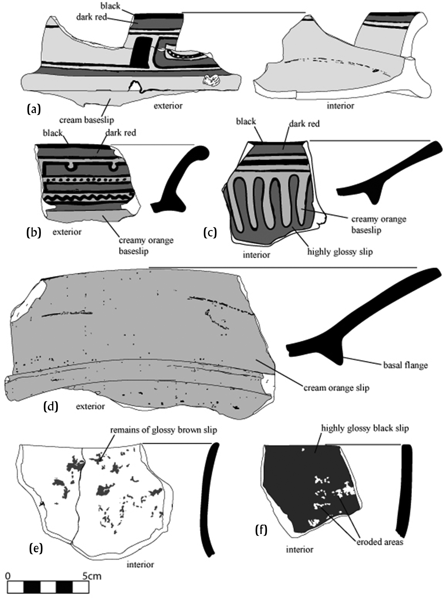
Figure 6. Early Classic ceramic types: (a) Yaloche Cream Polychrome; (b) Dos Arroyos Orange Polychrome; (c) Dos Arroyos Cream Polychrome, Opuesto variety; (d) Aguila Orange; (e) Pucte Brown; (f) Balanza Black. Illustrations by Eppich.
Excavators recovered large quantities of Early Classic ceramics from the upper layers of the Complex A platform and from the tunnels into the core of Structure A1. Such ceramics were also abundant in the Complex E architectural excavations, and in the small pyramids and underground chambers of Complex F. A picture emerges of substantial Early Classic construction activity and a settlement in florescence. In Complex A, the older Preclassic platform was reshaped, and a portion of it was chopped out to make room for the foundations of Structure A1. It is likely that much of the architecture in Complex A dates from this period, including the residential structures and the ballcourt. Most of Complex E—the large elite residence to the northeast—was also constructed at this time, as was the complex chultun in Complex F.
The Early Classic also sees clear emergence of recognizable elites. This is evidenced both in the quantity and quality of high-status-linked polychrome ceramics and in their concentration in the architectural residences and tombs of Complex A. The architecture houses a series of elite burials, including the Early Classic tombs in front of Structure A1 and Burials 74-1, 74-2, 74-4, 74-11, 74-13, and 74-14.
Ceramic Macrophase 3: the Late and Terminal Classic (ca. a.d. 550 to 790/810)
The seventh to ninth centuries saw continued occupation of the El Pozito core but without any evident large-scale construction or expansion. As in the case of the Early Classic, the Late Classic ceramic assemblage consists of ceramic types well known from the Northern Belize–southern Quintana Roo–northeast Peten area (Figure 7). These include such monochromes as Achote Black, Tinaja Red, and Corona Red. Among the elaborate Late Classic decorated types are Petkanche Orange Polychrome, Palmar Orange Polychrome, Calderitas Polychrome, Azcorra Ivory Polychrome, Agria Orange Polychrome, and Portia Gouged-Incised. Late Classic forms consist of large dishes and bowls with outcurving walls, large platters with outsloping walls and small medial ridges, flat-bottomed vases with direct rims, and small bowls with outsloping walls.

Figure 7. Late Classic ceramic types: (a) Portia Gouged-Incised; (b) Palmar Orange Polychrome; (c) Petkanche Orange Polychrome; (d) Tinaja Red; (e) Cubeta Incised; (f) Achote Black. Illustrations by Eppich.
One Late Classic ceramic type deserves special attention—Azcorra Ivory Polychrome, also known as “Posito Polychrome” (Figure 8). First identified at Becan (Ball Reference Ball1977:79; see also Pring Reference Pring and Hammond1976a), it is a highly distinctive ceramic distinguished by well-defined designs in red and black executed on a light brownish tan or ivory primary slip. In color, this slip is lighter and creamier than more reddish buff slips, possibly owing to the use of yellowish iron oxides in its preparation. Designs consist of fine-line depictions of animals or complex geometrics. Vessel forms are thick walled and robust, including large, steep-sided bowls and basins, and large shallow platters or deep plates (Eppich Reference Eppich2000:101). The type is common at several sites in Northern Belize, as at Pulltrouser Swamp, where Robert Fry (Reference Fry, Turner and Harrison1983:199) estimated that it makes up nearly half the polychrome ceramics there. At El Pozito, the type accounts for 79.6 percent of all Late Classic polychromes, suggesting that Azcorra Ivory Polychrome was either produced at or near El Pozito. From there, the ceramic was likely distributed outward (Ball Reference Ball, Sabloff and Henderson1993:260). It is also present in trace amounts at a number of sites in the Central and Northern Lowlands (Ball Reference Ball1977; Slater Reference Slater2014; Walker and Reese-Taylor Reference Walker and Reese-Taylor2012). This suggests that Azcorra Ivory Polychrome existed as a popular item within a prestige-gift economy or that it served an important role as a commercial commodity from Northern Belize. Of course, it could have been both.

Figure 8. Azcorra Ivory Polychrome. Illustration by Eppich.
Excavation notes from 1974–1976 make repeated references to Late Classic sherds found across the surface of the entire site. Late Classic ceramics were recovered from surface collections and in the upper excavation levels across Complex A, and on the surface and in the construction core at Complex E. Such ceramics were also found throughout the chultun of Complex F.
It appears that the Late Classic was a period of substantial occupation at the site. Evidence does not suggest any large-scale construction, but rather the continued use and modification of existing buildings from the Early Classic. At its height, El Pozito's population was likely one or two thousand individuals, comparable to similar estimates for Nohmul (Hammond Reference Hammond1985), although population numbers in the Maya region remain decidedly uncertain. By the end of the eighth century, Neivens and Puleston (Reference Neivens and Puleston1976a, Reference Neivens and Puleston1976b) believed that people had begun to abandon the El Pozito center. Very little is known about this abandonment—whether it took place abruptly within a very brief period of time, or slowly over the course of several decades, or even exactly when it occurred. Whatever the case, there does not appear to be any identifiable evidence of occupation at El Pozito by the middle to late ninth century.
Ceramic Macrophase 4: Full Terminal Classic (ca. a.d. 790/810 to 900)
Most likely, a light occupation of El Pozito continued into the ninth century for an indeterminate length of time. This is indicated by the scattered occurrence of small numbers of distinctive Terminal Classic ceramics. These include Daylight Orange, present with both Daylight and Darknight varieties; thin-slate wares, such as Ticul Thin Slate and Tabi Gouged-Incised; as well as the Chichen Red Ware ceramic type Dzibiac Red (Figure 9). This is in addition to as yet undesignated or unspecified local imitations of these. The Daylight Orange varieties have been found as far south as the Belize Valley (Gifford Reference Gifford1976) and north along the eastern Yucatan littoral as far as Vista Alegre in Quintana Roo (Ball et al. Reference Ball, Glover, Rissolo, Berdugo, Glover and Rissolo2010). Other identified Terminal Classic exotics occur continuously along the Quintana Roo coast from northern Belize to the northern plains of Yucatan (Ball Reference Ball and Sidrys1983; Kosakowsky et al. Reference Kosakowsky, Robertson, Sagebiel and Aimers2020; Sanders Reference Sanders1960; Smith Reference Smith1971).
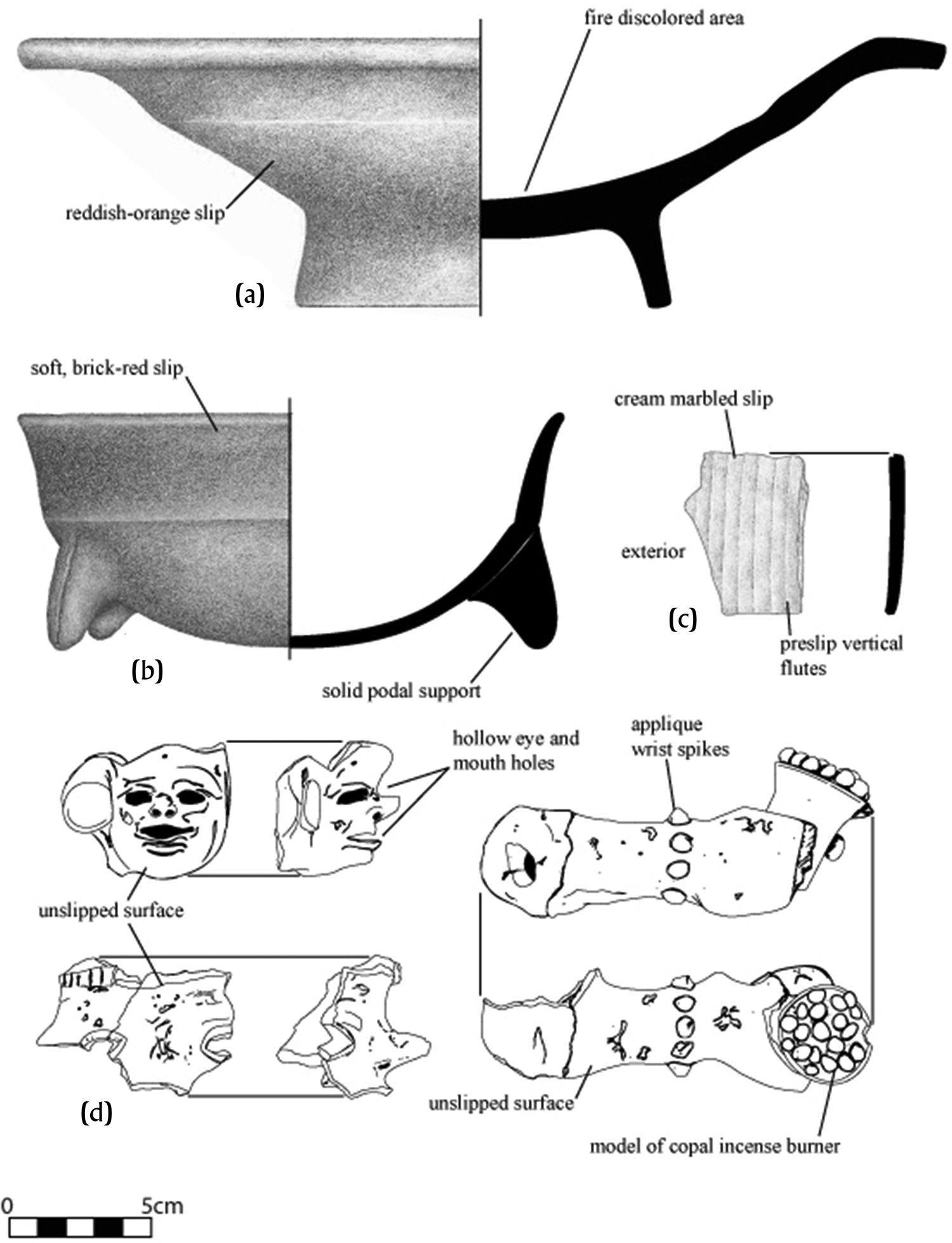
Figure 9. Terminal Classic and Postclassic ceramic types: (a) Dzibiac Red; (b) Payil Red; (c) Ticul Thin Slate; (d) Chen Mul Modeled censer fragments. Illustrations (a–c) by Jennifer Taschek and (d) by Eppich.
Chief among these Terminal Classic types is a distinctive zonal ceramic, Buyuk Striated (Figure 10). This type consists of unslipped, burnished, and striated globular, double-mouthed jars (Chase Reference Chase1982). It is also name tagged in the literature as “Aventura Striated” (Ball Reference Ball and Sidrys1983:206). Buyuk Striated is a zonal diagnostic of the Terminal Classic in Northern Belize, occurring at Calderitas in southeastern Quintana Roo and at distant Dzibilnocac in northeastern Campeche. These small, thick-walled jars likely functioned as ceramic canteens (Sidrys and Krowne Reference Sidrys, Krowne and Sidrys1983:234), and at El Pozito, a number were recovered from the bottom of the well in Complex E. Sidrys and Krowne (Reference Sidrys, Krowne and Sidrys1983) provide compelling evidence that Buyuk Striated jars were likely produced at or near Aventura, circulating out from there.

Figure 10. Buyuk Striated. Drawing by Eppich; form adapted from Sidrys and Krowne Reference Sidrys, Krowne and Sidrys1983.
A date for the large-scale occupational abandonment of the El Pozito center could not be determined from the limited scatter of Terminal Classic sherds but, based on known ceramic chronologies, this would have been no later than—and likely prior to—a.d. 900. Given the clear evidence of interaction with the Caribbean coast and the Yucatan centers of the era, the apparent absence of plumbate ware of any kind around a.d. 900 is likely significant in this regard.
Ceramic Macrophase 5: Full Postclassic (ca. a.d. 1350–1550)
Even after its presumed abandonment, local and itinerant Maya continued to visit and make use of abandoned El Pozito, a well-documented practice at many sites throughout the Lowlands (Hammond and Bobo Reference Hammond and Bobo1994; Lamoureux-St-Hilaire et al. Reference Lamoureux-St-Hilaire, Macrae, McCane, Parker and Iannone2015; Stanton and Magnoni Reference Stanton, Magnoni, Stanton and Magnoni2008). The abandoned structures probably served (1) as foci for ancestor veneration, (2) to build and maintain a connection to the past, (3) to sustain local long-term social cohesion, and (4) as a resting place for the honored dead. Simply by virtue of being ancient and venerated, the abandoned settlement likely took on the aura of a large-scale, open-air ancestor shrine (see McAnany Reference McAnany1995).
Ceramics associated with the full Postclassic include the Tulum Red Ware type, Payil Red, and the fine-paste ware Matillas Orange (Eppich Reference Eppich2000). These hail from coastal Quintana Roo and Yucatan to even as far distant as southwestern coastal Campeche. The postabandonment collections also contain ritually specialized ceramics, such as fragments of deliberately smashed Mayapan-style incensarios, probably of the Chen Mul Modeled type (Figure 9d). They occur in low quantities, lightly scattered across El Pozito. Small clusters appear in ritually significant places, such as the postabandonment hearth directly in front of Structure A1. They are also present in the chambers of the Complex F chultun. The largest single cluster was found on the summit of Structure A1. There, excavators encountered an intrusive burial accompanied by the gold bell noted earlier. They also documented fragments of Mayapan-style effigy censers on the summit, clearly marking it as a place of postabandonment ceremony. The local Maya continued to inter their dead at El Pozito, with Burial 44A in Complex F dating to this period. Several other burials in Complex E may also date from this time. Long after El Pozito ceased to be an active center, it continued to be a place of ritual importance lasting well into the sixteenth century.
Overview
The total sherd counts from the available El Pozito collections, sorted by ceramic macrophase, provide something of a tentative thumbnail sketch of the site's occupational history (Figure 11). Preclassic ceramics occur in modest quantities across the site, suggesting a light and scattered occupation on and around the locality. At some point toward the end of this period, the Maya constructed the initial Complex A platform, but the current resolution of the local ceramic tradition is not clear enough to accurately determine when in the Preclassic this construction occurred.

Figure 11. El Pozito total ceramic counts by time period.
Quantitatively, Early Classic ceramics dominate the collection and are associated with the construction of most of the visible architecture. The ceramic analysis argues that the Late Classic Maya inhabited a site largely constructed by the Early Classic Maya. The Maya of Late Classic El Pozito apparently preferred to use and modify existing buildings. After this, ceramic counts suggest an abandonment sometime early in the Terminal Classic period. In fact, there are more ceramic sherds from the full Postclassic period of the thirteenth to sixteenth centuries than there are from the ninth and tenth centuries. Veneration of the settlement's architecture and likely pilgrimage to them took place long after its effective abandonment.
In the end, it must be stressed that the sequence described above is only a rough approximation of the site's occupation and construction histories, and that the ceramic collections from El Pozito available for study may not be truly representative.
El Pozito in a regional and interregional context
The ceramics documented at El Pozito attest to a series of far-flung connections to, and interactions with, large parts of the Maya world. This is true both on the regional level of Northern Belize and in an interregional context that includes the entirety of the Maya Lowlands as El Pozito formed in the Preclassic, flourished in the Classic, and diminished in the Postclassic.
Preclassic El Pozito follows well-known ceramic patterns of Northern Belize (Kosakowsky et al. Reference Kosakowsky, Robertson, Sagebiel and Aimers2020). Across the region, the Early through the Middle Preclassic saw a smattering of small settlements, each possessing roughly similar sets of ceramic types and forms, all members of the temporally successive Mamom and Chicanel ceramic spheres (Ball Reference Ball1976; Willey et al. Reference Willey, Culbert T. and Adams1967). Although El Pozito has presently yielded no evidence of any Early Preclassic occupation, the Middle Preclassic is represented and indicates Mamom-sphere membership. The same holds true for the Late and Terminal Preclassic, with El Pozito and its neighbors sharing similar Chicanel-sphere ceramic types and forms.
A matter of continuing debate within Maya ceramic studies is what exactly these “ceramic spheres” indicate and what membership in a ceramic sphere signifies. Willey, Culbert, and Adams (Reference Willey, Culbert T. and Adams1967:306) originally defined ceramic spheres as simple material co-occurrences, when “two or more complexes share a majority of their most common [ceramic] types.” Joseph Ball (Reference Ball1976, Reference Ball, Sabloff and Henderson1993) expanded on this, describing spheres as composite groupings reflecting “common cultural traditions” but representing neither discrete populations nor political entities. Instead, Ball views spheres as the material expressions of multiple social and economic interaction systems—ones that shared common ideas regarding pottery shapes, surface treatments, slip colors, specific design elements, technology, and even paste recipes. Individual local traditions within ceramic spheres “shared values and information among a populace of both producers and consumers, and an unobstructed flow of both goods and ideas…” (Ball Reference Ball, Sabloff and Henderson1993:256– 257).
These goods and ideas moved through systems of social, political, and economic exchange. Prestige gift exchange of rare, high-quality ceramics is well documented (Houston et al. Reference Houston, Stuart, Taube and Kerr1992; Just Reference Just2012; Reents-Budet Reference Reents-Budet1994), with political actors presenting and receiving the products of specialized, court-attached (palace) ateliers that produced the most famous masterworks of Maya ceramic arts. Localized “village traditions,” by turns, either copied or inspired the palace schools, producing lesser—although still impressive—examples of polychrome pottery (Ball Reference Ball, Sabloff and Henderson1993; Reents-Budet et al. Reference Reents-Budet, Bishop and MacLeod1994). Parallel to the prestige exchange system ran strong commercial networks of ceramic trade. Several scholars (e.g., Bill Reference Bill and Braswell2014; Forsyth Reference Forsyth, López Varela and Foias2005) have suggested a commercial element underlying the patterns of ceramic spheres, and Eppich and Freidel (Reference Eppich, Freidel and King2015) argued that the overall pattern itself resulted from interlocked regional marketplaces. In any of the foregoing models, El Pozito's membership in these broadly shared ceramic spheres indicates the center's engagement in the complex economic and sociopolitical systems joining these traditions together.
Across Northern Belize, numerous small homesteads and hamlets emerged in the Early and Middle Preclassic to grow and establish themselves as viable village-level settlements and centers by the Late Preclassic (see Guderjan Reference Guderjan2007; Houk Reference Houk2015; López Varela Reference López Varela1996; McAnany and López Varela Reference McAnany and López Varela1999; Sagebiel Reference Sagebiel2005, among others). Among many others, these included Nohmul (Hammond Reference Hammond1974, Reference Hammond1985), Santa Rita Corozal (Ball Reference Ball and Sidrys1983), Cuello (Kosakowsky Reference Kosakowsky1987), La Milpa (Sagebiel Reference Sagebiel2005), Kichpanha (Reese and Valdez Reference Reese, Valdez, Rice and Sharer1987), Colha (Anthony and Black Reference Anthony, Black, Hester, Shafer and Eaton1994), and Aventura (Ball Reference Ball and Sidrys1983; Robin et al. Reference Robin, Kosakowsky, Grauer, Nissen and Jones2017; Robin et al. Reference Robin, Kosakowsky, Grauer, Nissen and Fitzgerald2019). Lamanai saw the construction of multiple massive platform pyramids, one of which rose over 33 m in height (Pendergast Reference Pendergast1981), and Cerros experienced a similar surge in population growth and construction (Freidel Reference Freidel1986). At Pulltrouser Swamp, just 20 km north of El Pozito, the Maya built extensive systems of ditched and raised fields for large-scale agricultural production (Turner and Harrison Reference Turner and Harrison1983:247).
Across the area, set patterns of rural complexity began to emerge, and the scale of population and settlement increased exponentially. The entire region shared all but identical sets of polished “waxy ware” ceramics, the easily identified Sierra and Polvero group types with very similar vessels forms (see Kosakowsky Reference Kosakowsky and Robin2012; Kosakowsky and Sagebiel Reference Kosakowsky and Sagebiel1999; Kosakowsky et al. Reference Kosakowsky, Robertson, Sagebiel and Aimers2020; Sagebiel Reference Sagebiel2005; Sullivan and Sagebiel Reference Sullivan, Sagebiel, Scarborough, Valdez and Dunning2003). These same forms and types were documented at El Pozito as well, making the site, even at this nascent stage, part of this emergent complexity (Eppich Reference Eppich2000).
As the Early Classic dawned across Northern Belize, local ceramic traditions underwent significant large-scale transformation. Interactions with the large cities of the eastern Peten and southern Quintana Roo are reflected in the spread of the Tzakol ceramic sphere. El Pozito manifests all the characteristics of this ceramic sphere, possessing what Ball (Reference Ball1976:323) termed “full sphere membership.” These characteristics include such hallmark ceramic groups and constituent types as the Aguila, Balanza, Pucte, Dos Arroyos, and early Palmar, all well represented at El Pozito (Case Reference Case1982; Eppich Reference Eppich2000). El Pozito blossomed over this period, as did numerous other sites along the Hondo and Nuevo rivers, including Santa Rita Corozal (Ball Reference Ball and Sidrys1983; Chase Reference Chase, Patrick Culbert and Rice1990; Chase and Chase Reference Chase and Chase1986), Cuello (Hammond Reference Hammond1991; Kosakowsky Reference Kosakowsky1987), Kichpanha (Root-Garey Reference Root-Garey2010), Aventura (Robin et al. Reference Robin, Kosakowsky, Grauer, Nissen and Jones2017; Robin et al. Reference Robin, Kosakowsky, Grauer, Nissen and Fitzgerald2019), Nohmul (Hammond Reference Hammond1985; Kosakowsky and Pring Reference Kosakowsky and Pring2001), and Colha, with its large-scale chert workshop in full production by this time (Anthony and Black Reference Anthony, Black, Hester, Shafer and Eaton1994; Shafer and Hester Reference Shafer and Hester1983; see also Pyburn et al. Reference Pyburn, Boyd Dixon and McNair2013). To the east, Altun Ha grew into a substantial center, complete with a 2 km2 core of palaces and large pyramids (Pendergast Reference Pendergast1979, Reference Pendergast1982; see also Houk Reference Houk2015). Meanwhile, other sites began a decline that ended in abandonment. Notable among these is Cerros (Reese-Taylor and Walker Reference Reese-Taylor, Walker, Masson and Freidel2002), its decline possibly marked with a violent end (see Rosenswig and Kennett Reference Rosenswig and Kennett2008). Although no single urban megacenter appears to have emerged in Classic Northern Belize, the region was home to numerous prosperous small settlements scattered across its rivers and ridges.
Throughout Northern Belize, the Early Classic seems to have merged almost seamlessly into the full Late Classic, local ceramic assemblages uniformly falling comfortably within the broader Tepeu ceramic sphere. The patterns of common types and forms extended from the central and northern Peten into northern Belize, southern Quintana Roo, and southern Campeche, and westward into Chiapas. El Pozito followed this pattern, its ceramics reflecting full membership in this expansive sphere. The principal decorated wares of El Pozito's transition from Early to Late Classic were a distinct pair: Pellejo Buff Polychrome and Azcorra Ivory Polychrome. The first, Pellejo, consists of low-gloss red and black designs on an unslipped-burnished buff surface. The second, Azcorra, possesses polychrome designs on a thinly slipped dirty cream base (see Fry Reference Fry, Turner and Harrison1983:1991). These two ceramic types were first identified at Becan in 1970 and were labeled as exotic ceramics of northern Belizean origin (Ball Reference Ball1973, Reference Ball1977:79). Often combined and labeled with a variety of terms, such as “Azcorra Buff” or “Posito Polychrome,” they should be recognized as two distinct types, as they originally were (see Ball Reference Ball1973:163–165).
Apart from Becan, the known distributions of Pellejo Buff and Azcorra Ivory Polychrome extend across a zone from Cuello (Ball Reference Ball and Hammond1979:56) south to San Jose (Thompson Reference Thompson1939:Figure 56a, 56f–g) and Altun Ha. It does not appear to be present in the Belize Valley or on Moho Cay, nor is it known from the central Peten (Ball, personal observations 1978–2012). North of Cuello, Fry (Reference Fry, Turner and Harrison1983:199, 208) reports the type as Azcorra Buff and notes its abundance at Kokeal, a site in the southernmost extreme of Pulltrouser. It is also known to occur at Caledonia (Ball Reference Ball and Sidrys1983:213–215). Fry (Reference Fry, Rice and Sharer1987:117) also notes its appearance at a number of sites in southern Quintana Roo.
Both Azcorra Ivory Polychrome and Pellejo Buff Polychrome were likely manufactured at El Pozito, and their documented distribution signals the settlement's active participation in a dynamic exchange system extending across the whole of Northern Belize and deep into the heart of the southern Yucatan Peninsula, possibly even reaching the center of the massive Kaanu'l polity itself (see Canuto and Barrientos Q. Reference Canuto and Barrientos Q.2011; García Capistrán Reference García Capistrán2012; Martin Reference Martin2020). Direct epigraphic links with Kaanu'l are also manifest at this time in a sculpted panel from Tz'unum (Hanratty et al. Reference Hanratty, Love, Guenter and Guderjan2016; Stuart Reference Stuart2017).
The ceramic patterns suggest, however, that such interaction was neither steady nor sustained for the entire Late Classic. Multiple decorated fine ceramics of the seventh and early eighth centuries occur at El Pozito, including Palmar Orange Polychrome, ubiquitous across the Late Classic Lowlands; Agria Orange Polychrome, itself distributed from Northern Belize to southeastern Campeche; Egoista Resist, widespread and ubiquitous across the northern Lowlands; and even the elegant Petkanche Orange Polychrome, which is concentrated in Northern Belize but widely distributed across the whole of the Maya Lowlands (Ball Reference Ball, Sabloff and Henderson1993:Figure 6). In fact, this very striking polychrome may actually have been produced at Altun Ha. On the other hand, well-known eighth-century ceramic types—such as Zacatal Cream polychrome, Paixban Buff Polychrome, and Cabrito Cream Polychrome, popular and documented elsewhere—are notable for their apparent absence at El Pozito. Clearly, these regional and interregional interactions are complex and dynamic, even within the supposed uniformity of the Tepeu ceramic sphere.
At some time in the later eighth or early ninth century, El Pozito was largely abandoned, as were many other once-thriving Late Classic settlements in Northern Belize. Other zonal centers persisted and even flourished during this time, among them Aventura (Ball Reference Ball and Sidrys1983; Kosakowsky et al. Reference Kosakowsky, Robertson, Sagebiel and Aimers2020; Robin et al. Reference Robin, Kosakowsky, Grauer, Nissen and Jones2017; Robin et al. Reference Robin, Kosakowsky, Grauer, Nissen and Fitzgerald2019), Santa Rita Corozal (Chase Reference Chase, Patrick Culbert and Rice1990; Chase and Chase Reference Chase and Chase1986), Lamanai (Pendergast Reference Pendergast1981), and likely yet others that still remain to be documented.
In some cases, small settlements reoccupied older sites, as was the case at Nohmul (Hammond Reference Hammond1985) and Cerros (Walker Reference Walker1990; see also Vadala and Walker Reference Vadala and Walker2020). Clearly, a significant if not substantial Maya population remained across the area. Small-scale ritual activity attests to this, documented at many abandoned sites, such as Altun Ha (Pendergast Reference Pendergast1982) and El Pozito. Yet, the area was not divorced from the greater Maya world. Ceramics associated with this ritual activity are strongly suggestive of the Northern Yucatan ceramic spheres, with Cehpech and Sotuta influences reflected in local ceramics (Ball Reference Ball1976). As has long been observed for the ninth century, the heretofore shared ceramic traditions of the Late Classic splintered into multiple, smaller, highly regionalized patterns (Ball Reference Ball, Sabloff and Henderson1993:n13; Willey et al. Reference Willey, Culbert T. and Adams1967). Ceramic traditions in Belize grew ever more localized and heterogeneous, so much so that Donald Forsyth (Reference Forsyth, López Varela and Foias2005) characterized them as separate, distinct traditions within a broader Belize region (see also “co-traditions,” Phillips and Willey Reference Phillips and Willey1953:627). Probably, this was the pattern across Northern Belize—highly localized yet interlinked ceramic expressions with scattered exotics and influences from the distant centers of coastal Quintana Roo and Yucatan.
Towns as economic interfaces
The ceramic data clearly show sustained linkage between this one small site and its neighbors, and the greater Maya world, with those connections being at their greatest during the Classic period. What do such linkages imply? Towns, in a medieval European context, served as the economic interface between rural areas and the larger world, with part of this interface consisting of the movement of agricultural produce toward large population centers (Dyer Reference Dyer, Davies and Galloway2012).
There is considerable evidence suggesting that this may also be the case with Northern Belize. Geographers and archaeologists long ago established the presence of intensive agriculture along the Hondo–Nuevo River systems. Some of the original research documenting the antiquity of such systems took place at Pulltrouser Swamp, 25 km north of El Pozito (Harrison Reference Harrison and Fedick1996; Turner Reference Turner II, Turner II and Harrison1983; Turner and Harrison Reference Turner and Harrison1983). Raised and ditched fields and river channelings were begun in the Late Preclassic, by or before 200 b.c., and thereafter continuously used, modified, and expanded throughout the Classic period (Beach et al. Reference Beach, Luzzadder-Beach, Krause, Guderjan, Valdez, Fernandez-Diaz, Eshleman and Doyle2019). Investigators identified similar patterns at Albion Island on the Rio Hondo just across the ridge from Pulltrouser Swamp (Bloom et al. Reference Bloom, Pohl, Buttleman, Wiseman, Covich, Miksicek, Ball and Stein1983; Pohl Reference Pohl1990; Pohl and Bloom Reference Pohl, Bloom and Scott L.1996). There, Anne Pyburn and her associates (Reference Pyburn, Boyd Dixon and McNair2013) also recorded substantial rural settlement that indicated a heavily populated countryside working the ditched fields and canals (see also Kunen and Hughbanks Reference Kunen, Hughbanks, Scarborough, Valdez and Dunning2003; McAnany et al. Reference McAnany, Berry, Thomas, Iannone and Connell2003; Wyatt Reference Wyatt and Robin2012). Such extensive field–canal systems would have allowed for substantial levels of year-round agricultural production.
Farther upstream on the Hondo, Thomas Guderjan documented similar systems around the site of Blue Creek (Guderjan and Krause Reference Guderjan and Krause2011). He points out that the agricultural output of these fields would have far exceeded local needs, concluding from this that “the sheer scale of the production systems at Blue Creek and downstream along the Rio Hondo give us reason to think that the systems were designed for commercial export” (Guderjan et al. Reference Guderjan, Luzzadder-Beach, Beach, Bozarth, Krause, Mathews and Guderjan2017:48). Anne Pyburn (Pyburn et al. Reference Pyburn, Boyd Dixon and McNair2013) goes even further, suggesting large-scale commercial farming for shipment up the Hondo to Nakum and other cities of the eastern Peten. Although still less than certain, palynological data suggest that the most likely crops were corn and possibly cotton (Turner and Harrison Reference Turner and Harrison1983:258–259; see also Beach et al. Reference Beach, Luzzadder-Beach, Krause, Guderjan, Valdez, Fernandez-Diaz, Eshleman and Doyle2019). This exchange served as one portion of a highly complex, commercialized economy, the scope and scale of which scholars have only recently come to appreciate (Freidel et al. Reference Freidel, Masson and Rich2017; Hirth and Pillsbury Reference Hirth and Pillsbury2013; King Reference King, Hutson and Ardren2022; King, ed. Reference King2015; Masson et al. Reference Masson, Freidel and Demarest2020).
In return for such produce, material goods flowed into the communities of the Hondo–Nuevo drainage. These goods included not just the tens of thousands of obsidian blades and imported polychromes found at El Pozito but also the sumptuous jades and stunning Tzakol-sphere polychromes of Blue Creek (Guderjan Reference Guderjan2007; Guderjan and Hanratty Reference Guderjan, Hanratty, Iannone, Houk and Schwake2016) and the elaborate polychrome ceramics and jade treasures of Altun Ha (Pendergast Reference Pendergast1982). Nearby Nohmul also has its own store of jades and rich burials loaded with obsidian and large Peten- style polychrome vessels (Hammond Reference Hammond1984; Houk Reference Houk2015; Kosakowsky, personal communication Reference Kosakowsky, Robertson, Sagebiel and Aimers2020). Indeed, one of the striking features of the Classic sites in Northern Belize is the outsized degree of material wealth present, especially for so many scattered settlements of only a few hundred or so individuals. El Pozito was one these communities, thriving amid an intensively farmed landscape, surrounded by a large rural, agrarian population. These farmers seem to have raised crops for shipment and trade—most likely to the Yucatan and Peten—and received a considerable bounty of branded goods in return.
At least some of the finer polychromes and exotic decorated wares found in Northern Belize likely circulated as prestige goods from the Peten and Quintana Roo, with political gifts and commercial goods crossing paths along the same exchange routes. This does raise some interesting questions about the active participants engaged in such exchange. Politically, Classic Belize north of Lamanai has always been something of an oddity in Maya studies, a collection of prosperous small and medium-sized settlements lacking any truly large urban center. Scholars have characterized this pattern—a collection of smaller, near-peer equals—as specialized communities with heterarchical relationships scattered across a landscape of rural complexity (Iannone and Connell, ed. Reference Iannone and Connell2003; Scarborough and Valdez Reference Scarborough, Valdez, Scarborough, Valdez and Dunning2003). There are, of course, some larger centers, such as La Milpa, Aventura, and Nohmul, but there is no evidence that they exerted any direct political control over larger swaths of this rural landscape. In much simpler terms, these settlements seem to be wealthy, independent towns surrounded by farming country. Together, town and country raised and sold agricultural produce and, in part, received gifts and goods from distant cities to facilitate that trade.
In this model, the Classic Maya towns of Northern Belize exerted little political influence on the complex rural landscape that surrounded them. Instead, they served the needs of the inhabitants of that landscape, and their principal need was likely commercial. Farmers worked the large-scale, extensive agricultural fields of the Hondo–Nuevo rivers and brought their harvests into these towns for sale and eventual movement upriver to the cities of the Peten, as suggested by Guderjan and colleagues (Reference Guderjan, Luzzadder-Beach, Beach, Bozarth, Krause, Mathews and Guderjan2017) and Pyburn and colleagues (Reference Pyburn, Boyd Dixon and McNair2013), in a Classic Maya version of Dyer's (Reference Dyer, Davies and Galloway2012) “Feeding the City” project. In return, the farmers received payment and purchased tools and luxuries, taking advantage of the commerce present in the local town. At El Pozito, such commercial urban functionality manifested itself in the obsidian from the workshop documented by Neivens and Libbey (Reference Neivens1976) as well as the Azcorra Ivory and Pellejo Buff Polychromes likely manufactured there (Ball Reference Ball, Sabloff and Henderson1993). The complexity of the countryside contained multiple specialist communities—small settlements focusing on a limited range of products, or even just one (Scarborough et al Reference Scarborough, Valdez and Dunning2003:7). These specialist communities contributed to this regional trade, with Colha workshops producing high-quality chert tools, axes, and adzes for those local farmers (Hester et al. Reference Hester, Eaton and Shafer1980; Hester et al. Reference Hester, Eaton, Shafer and Adams1982; Shafer and Hester Reference Shafer and Hester1983). Small communities along the coast also participated, supplying fish, salt, and possibly shell to those same towns (Mock Reference Mock1997; Valdez and Mock Reference Valdez and Mock1991). These towns, including El Pozito, functioned as economic nodes in a landscape of rural complexity, connecting specialist communities to farming communities and connecting all to the larger Maya world beyond the Hondo and Nuevo rivers (see Ingalls and Yaeger Reference Ingalls and Yaeger2022; Valdez et al. Reference Valdez, Trachman and Cortes-Rincon2022). Such towns, like the El Pozito site, can be understood only within the context of such a complex landscape.
What was El Pozito?
El Pozito was, in academic terms, a middle-sized settlement with low levels of urban functionality in a landscape of rural complexity. The settlement's functionality seems largely limited to commercial roles, manifest in its obsidian and likely ceramic workshops, and in the Colha chert tools and ceramic linkages on both regional and interregional scales. A limited religious function is likely as well, with El Pozito's small pyramid and complex chultun serving as the location for sacred and ritual events. Absent entirely is any apparent political authority or military role for the settlement. There is no large, multicourt palace with multiple rooms capable of housing a sizeable noble court. There are no moats, ditches, walls, or other defensive features. There does not seem to be any large-scale population nucleated in the site core. Except for its location in Mesoamerica, El Pozito almost ideally fits Christopher Dyer's Reference Dyer2003 definition of a medieval town.
To draw this out more explicitly, Dyer's definition consisted of a small settlement of fewer than 2,000 inhabitants and fewer than 400 structures—just like El Pozito. The town possessed craft production of items for the surrounding agrarian countryside, just as El Pozito possessed an obsidian workshop and likely one, or possibly two, ceramic workshops. Dyer identified crafting activities around the edges of the town center, reflecting the location of El Pozito's obsidian workshop and possibly predicting the location of ceramics production. Dyer placed a marketplace in the center of the town and, although no marketplace was detected at El Pozito, no one thought to look for one in 1974. Such towns possessed small-scale religious and political functions, such as El Pozito's pyramid and chultun, open plaza, and elite residences. Any future research at El Pozito—and it is hoped that such research takes place—would be well advised to look for additional workshops and a marketplace, and to flesh out any additional political or religious functions. Most of the obsidian workshop was never unearthed. Pottery workshops remain rare in Maya archaeology, and El Pozito is a prime candidate to contain at least one. The marketplace of El Pozito, in particular, should be an especially rich trove of information on regional exchange. With secure archaeological provenience, the ceramic macrophases here could even be converted into more formal ceramic complexes.
El Pozito was a Classic Maya town. The town was situated on a low ridge between a pair of rivers (today, the Hondo and Nuevo), whose banks were lined with terraces, raised fields, and canals—extensive earthworks designed to intensify agricultural production. Small farms and farming communities filled the countryside around the town, building, maintaining, and working these earthworks. It was a countryside of small farmers, who were not necessarily beholden to anyone in the nearby town (Robin Reference Robin2012; cf. Pyburn et al. Reference Pyburn, Boyd Dixon and McNair2013; see also Díaz et al. Reference Díaz, Aragon, Coba and Aguilar2022; Lamb Reference Lamb2022b). They raised corn, perhaps cotton, and possibly beans, squash, camotes, avocado, cacao, and even manioc. They brought their harvest into the town for sale. There, they purchased tools from Colha, salted fish from the sea, obsidian blades from the nearby workshop, and buff-colored or ivory-colored polychrome pottery of the local ceramic traditions.
El Pozito was one of several similar towns that dotted the San Pablo Ridge, running all the way to the sea. Some of these towns were smaller, others were larger, and some—such as Aventura—could even be called small cities. Although these towns differed in some aspects, they likely all shared the same broad functionality, serving the system of rural complexity in the farmlands around them. They possessed markets and workshops to serve local commercial needs, as well as sacred roads and pyramids to serve local religious needs. They connected the small farmers to the wider Classic Maya world and even to the distant, big cities of the Peten and Yucatan. These towns were not equal, but they were not likely political subordinates of one another. There is little evidence to suggest regal ambitions among the Maya towns of Northern Belize. The most likely political situation was one of heterarchy—political near peers economically interdependent on one another (Scarborough and Valdez Reference Scarborough, Valdez, Scarborough, Valdez and Dunning2003). Such interdependency likely obviated the rise of any single powerful center, as was the case in other parts of the Classic Maya world.
El Pozito consisted of a double center: two sets of shrines and residences separated by a bajo. It possibly comprised a pair of communities, each resident in and tied to its own specific complex. Although admittedly speculative, this may be the Classic equivalent of a twin cahob town, a type of settlement described as typical of the Colonial Yucatec by ethnohistorian Matthew Restall (Reference Restall1997:13–40, especially 37–38). These settlements comprised a linked pair of communities, each containing a hierarchy of lineages within them. Structurally, the pattern is very much like what might be expected of what some archaeologists recently have recognized as settlement “neighborhoods” (Peuramaki-Brown Reference Peuramaki-Brown2014; Smith Reference Smith2010, Reference Smith2011).
Such communities often extended beyond the town itself and included several villages throughout a given region. If so, El Pozito was dominated by a pair of elite lineages, each the head of its own individual community, but both residing within and sharing the dual town center. Together, they maintained the local market and sponsored local crafters, including obsidian knappers and polychrome potters. Possibly, the dichotomous burnished-surface buff-colored (Pellejo) and thin-slipped ivory-colored (Azcorra) wares reflected and even were a product of this duality. Together, these two potteries represented and even stood for “El Pozito.” Separately, they were produced by and stood for each of the town's two distinct neighborhoods or cahob. The last is just a thought experiment, of course, but it does seem both plausible and possible.
As one, the two sectors that were El Pozito also facilitated the movement of goods in both regional and long-distance exchange, likely serving as the equivalent of a local merchant class upon which the economic and social health of the town was dependent. They likely held religious events in front of their respective pyramid shrines, possibly coinciding with the height of the market season (Freidel Reference Freidel and Ashmore1981). Inside those pyramids, they buried their ancestors, accompanied by the rich funerary goods that attest to their success in these endeavors.
El Pozito formed as a Maya town sometime in the fourth century. The local Maya built most of their town during the Early Classic, maintaining and elaborating its architecture for the next 400 years—roughly 20 generations. The end of El Pozito came within the broad temporal and cultural context of the “Classic Maya Collapse,” an event that in general did not seem to strike Northern Belize particularly hard (Buttles and Valdez Reference Buttles, Valdez, Iannone, Houk and Schwake2016; Guderjan and Hanratty Reference Guderjan, Hanratty, Iannone, Houk and Schwake2016; Houk Reference Houk, Iannone, Houk and Schwake2016). The region certainly lacks evidence of the widespread destructions and abandonments seen in other portions of the Classic world (Demarest et al. Reference Demarest, Quintanilla, Suasnavar, Iannone, Houk and Schwake2016; Inomata Reference Inomata, Inomata and Webb2003; O'Mansky and Dunning Reference O'Mansky, Dunning, Demarest, Rice and Rice2004). To some extent, this has even led some scholars to question the idea that the Classic Maya collapsed at all (Aimers Reference Aimers2007; McAnany and Negrón Reference McAnany, Negrón, McAnany and Yoffee2010). The research at El Pozito suggests, however, that had it and other similar market towns been tied economically to the major cities of the Classic World, then the end of those big urban centers could well have resulted not in a violent collapse in Northern Belize, but rather a generalized, economic unraveling and failure. Deprived of large-scale external markets, intensive agriculture would have served little purpose, and farmers would have returned to smaller-scale production aimed at local needs or a greatly diminished coastal trade. Certainly, the Dzibiac Red bowls and golden bells of El Pozito do suggest some continued interaction with the centers of Northern Yucatan; however, most market towns would gradually have grown poorer and eventually have been abandoned altogether, as appears to have occurred in the case of El Pozito. Local farmers continued to venerate the fallen architecture, using them as an open-air shrine—a monument to distant ancestors.
El Pozito was a Classic Maya town. It lived and died, not on the margins of Classic Maya civilization, but as an intrinsically interconnected part of it. Just as the big cities of the interior cannot be understood without appreciation of the social, political, and economic interconnectivity of the Classic Maya world, Northern Belize cannot be understood as a series of individual sites, but only as an interconnected composite of many interdependent specialist communities. It is highly likely that the produce of the Hondo and Nuevo Rivers fed the large urban centers of the interior: El Pozito and other similar towns helped interconnect this ancient landscape of rural complexity.
Acknowledgments
We dedicate this article to Mary Baglan Neivens and Dennis E. Puleston, who together pioneered the archaeological investigation of El Pozito between 1974 and 1976. Neivens made her collections available to Ball for study at San Diego State in 1978. A large representative-type collection was repatriated to the Department of Archaeology, Belize, in 1981, and, at Neivens's request, a substantial part of the remaining collection was transferred to Norman Hammond at Rutgers University in 1984. A small representative-type collection is currently curated by the Collections Management Facility at San Diego State University. The authors thank all who in any way made access to the El Pozito material for study possible, most especially to Mary Neivens and former Belize Commissioner of Archaeology Harriot Topsey. Special thanks to Laura Kosakowsky who read and offered helpful comments on two earlier versions of this article. The authors alone are responsible for any errors of fact or interpretation from which the study may still suffer.


 Open access