


Introduction
Archaeologists and ecologists have documented the persistent importance of bofedales—high altitude, anthropogenic wetlands that provide high-quality, perennial vegetation—for pastoral ecologies (e.g. Verzijl & Guerrero Quispe Reference Verzijl and Quispe2013; Lopez-i-Gelats et al. Reference Lopez-i-Gelats, Contreras Paco, Huilcas Huayra, Siguas Robles, Quispe Peña and Bartolomé Filella2015; Lane Reference Lane2017). However, studying the complex relationships between Andean herders and their lands has proved challenging, in part because pastoralist territories can extend far beyond the scale of areas that can be covered systematically through field survey. Recent archaeological studies have combined pedestrian survey with environmental modelling to demonstrate that herding infrastructure—specifically, estancias (pastoralist settlements) and movement corridors—are associated with more productive, seasonally stable vegetation, often associated with bofedales (Vining Reference Vining, Capriles and Tripcevich2016; Vining & Williams Reference Vining and Williams2020). These findings suggest that herders may have located their corrals and estancias to take advantage of these resources.
We build on these approaches to consider long-term, trans-regional patterns in the relationship between pastoralism and the environment—specifically, vegetation productivity and stability—in the Department of Huancavelica, Peru (Figure 1). We consider possible interpretations of observed patterns in the distribution of features identified as corrals and estancias and their environmental contexts with reference to data on colonial period Huancavelica. Because of its silver and mercury mines, Huancavelica served a critical role within the colonial economy (Robins Reference Robins2011). Transport services provided by herders were essential in both the export of mined materials and in the provisioning of remote mining centres (Cobb Reference Cobb1949). Evidence from Huancavelica and Potosí suggests that camelid caravanning persisted despite the introduction of non-native animals such as mules, because camelids were inexpensive, plentiful and adapted to the terrain and its foraging resources (Cobb Reference Cobb1949; Bernabé Romero Reference Bernabé Romero2015). The need to intensify herding activity to sustain greater numbers of caravans likely impacted pastoral ecologies, but how this intensification transformed long-held relationships between herders, animals and their environments remains unclear.

Figure 1. Map showing location of Huancavelica and survey zone (figure by the authors).
We use multiple large-scale datasets, including imagery survey and vegetation indices, to examine the distribution and environmental context of corrals and estancias in Huancavelica. Remote surveys often suffer from a lack of chronological specificity; however, as Franklin and Hammer (Reference Franklin and Hammer2018: 1) note, such “palimpsest landscapes” can often be “temporally disentangle[d]” through the integration of other data. Here, the incorporation of supplemental data strengthened our two primary findings: firstly, that corrals and estancias cluster around major colonial period and present-day settlements; and, secondly, that there is a statistically significant relationship between pastoral infrastructure and perennial vegetation.
Andean pastoralist environments
Today, Andean camelid pastoralism is predominantly practised in high-elevation grassland regions between 4100 and 4800m above sea level (asl), frequently referred to as the puna (Pulgar Vidal Reference Pulgar Vidal1946). In Huancavelica, the puna is characterised by significant seasonal variation in precipitation, with marked wet (November–April) and dry (May–October) seasons. Seasonal temperature variation is minimal, while diurnal variation is high and frost is possible year-round (Winterhalder & Thomas Reference Winterhalder and Thomas1978: 21). Precipitation is unpredictable and often localised, making water availability a key limiting factor for herders.
In this context, bofedales are critical pastoral resources, providing high-quality pasture and consistent water availability within the puna (Squeo et al. Reference Squeo, Warner, Aravena and Espinoza2006; Vining Reference Vining2012: 119–34; Chimner et al. Reference Chimner2019, Reference Chimner2020). Grassy and forb species in bofedales are higher in biomass and protein content than similar non-bofedal pasture and are particularly important resources for alpacas, who have less dietary flexibility than llamas (Reiner & Bryant Reference Reiner and Bryant1986; Castellaro et al. Reference Castellaro, Ullrich, Wackwitz and Raggi2004). Herders also rely on bofedales to bridge dry-season gaps in the availability of other pasture (Palacios Rios Reference Palacios Rios and Ochoa1988: 96). Based on these factors, we hypothesised that the distribution of corrals and estancias in Huancavelica would correlate with that of bofedales.
The contemporary distribution of bofedales reflects long-term pastoral land management practices. Herders augment bofedales through the construction of features including channels and silt dams, and the practice of periodic deliberate flooding (Palacios Rios Reference Palacios Rios and Ochoa1988; Lane Reference Lane2006: 498; Reference Lane2009, Reference Lane2017; Cooper et al. Reference Cooper, Wolf, Colson, Vering, Granda and Meyer2010; Verzijl & Guerrero Quispe Reference Verzijl and Quispe2013; Lane et al. Reference Lane2022). In turn, these activities are dynamically related to other elements of pastoral political economies. For example, Vining (Reference Vining, Capriles and Tripcevich2016) suggests that heightened demand for textiles during the Tiwanaku expansion (AD 600–1000) led to community fission, as households moved closer to bofedales to increase herding capacity and thus to intensify fibre production. Another study, by Vining and Williams (Reference Vining and Williams2020), found that route corridors between Tiwanaku and its colonies are associated with higher biotic productivity, indicating that the need for pasture along the route led communities to foster the development of high-value pasture. These examples suggest the possibility that rural herders may have responded to the shifting demands of the colonial economy by changing their environmental management practices, with concomitant impacts on pastoral settlement patterns.
Virtual survey and remote sensing methods
Testing the possible association between herding infrastructure and vegetation quality requires multiple large-scale datasets that cover the vast regions these landscapes encompass. Pastoral landscapes are well-suited to imagery survey, as corrals and estancias are visually distinctive and often situated in areas of sparse land cover. Evaluating the chronology of these features using satellite data is difficult, just as it is in field-based research: stone corrals are challenging to date and efforts to date them via excavation and surface collection are rarely scalable. Nevertheless, we seek to leverage the large scale of imagery survey to identify patterns in corral and estancia distribution and environmental context.
Remote survey using GeoPACHA
Our use of the Geospatial Platform for Andean Culture, History and Archaeology (GeoPACHA) facilitated collaborative, large-scale, systematic imagery survey of the Andes; this article presents findings from the south-central highlands survey team. Survey comprised data collection and review. As in other GeoPACHA projects, survey was tracked through a grid-based system. First, team members recorded all archaeological features within a 2 × 2km grid cell and assigned them a locus type, subtype and confidence probability; these points were verified by the regional editor (Whitlock) and, finally, by the general editors (Wernke and VanValkenburgh). As discussed by Wernke and colleagues (Wernke et al. Reference Wernke2023, as part of the Antiquity GeoPACHA series), ‘locus’ is the atomic unit of analysis in GeoPACHA. To accommodate diverse research agendas, a locus may include a single or multiple features, depending on the locus type and subtype. Corral loci recorded ranged from single corrals to corral complexes with upwards of 20 individual corrals. We define an ‘estancia’ as a locus that contains corrals and domestic structures, distinguishing between different types of pastoralist infrastructure (Figure 2; see Vining Reference Vining, Capriles and Tripcevich2016: 95; cf. Baitzel et al. Reference Baitzel, Polo y La Borda, Konecky, Sae-Lim and Rivero Infante2022: 2).

Figure 2. Examples of corrals (top row) and estancias (bottom row) in satellite imagery. Coloured dots indicate sites recorded in GeoPACHA (figure by the authors).
Survey in Huancavelica used two complementary coverage strategies: transects and a central contiguous survey zone (Figure 1). Transects running north-south and east-west consisted of single-width lines of 2 × 2km survey cells separated by approximately 10km. We also surveyed a contiguous zone running south-west from the city of Huancavelica towards Chincha, which follows historic understandings of the ‘Mercury Road’ that connected Huancavelica with ports during the colonial period (Bauer et al. Reference Bauer, Smit, Blanco, Rodríguez, Chacaltana, Arkush and Marcone2017). While transects are useful for covering a large area, a contiguous survey zone enables spatial statistical characterisations of locus distributions. Following this data collection phase, we reviewed all points to ensure consistency of type and subtype registry across loci. Though we registered many types of archaeological loci, we focus here on corrals and estancias.
Characterising distributions of pastoralist infrastructure
We used optimised hot-spot analysis to characterise clustering of corrals and estancias within the contiguous survey zone. We chose optimised hot-spot analysis—an implementation of the Getis-Ord Gi* spatial statistic that bins point distributions within a polygon mesh—because our survey data are incident data (present/absent). The tool identifies statistically significant spatial clusters of high values (hot spots) and low values (cold spots), which indicate where herding activities were—or were not—focused. We experimented with distance bands (from 1 to 10km) to examine different scales of clustering. Both corrals and estancias show clustering beginning with a distance band of 1km, when they begin to cluster around the city of Huancavelica. Cold spots do not occur until the 3km band for corrals and the 6km band for estancias and are concentrated in the lower elevation zones of the contiguous survey zone. We opted to use these bands—3km for corrals and 6km for estancias—to enable the comparison of hot and cold spots. We used a 500m cell size for similar reasons; variation within the data was evident but it minimised the extent of localised variation observed with smaller cell sizes.
Examining environmental context
To examine our hypothesis that the distribution of pastoral infrastructure correlates with that of bofedales, we compared the observed distributions of estancias and corrals across the entire survey area and their association with high-quality forage (using proxy measures outlined below) against null hypothesis (random) distributions of points. Other researchers have similarly used present-day data to infer environmental conditions in the past (Vining Reference Vining, Capriles and Tripcevich2016; Vining & Williams Reference Vining and Williams2020).
The Normalised Difference Vegetation Index (NDVI) measures vegetation productivity from satellite imagery by estimating the density of green coverage in an area; higher values equate to higher productivity. NDVI values can be misleading in high-elevation settings as vegetation productivity tends to reduce with increasing altitude (e.g. Yuan et al. Reference Yuan, Wang, Xu and Wu2021). We therefore use NDVI not as an absolute measure of productivity, but to compare the relative productivity of different highland areas. A related metric, the Normalised Difference Seasonal Vegetation Index (NDSVI), quantifies the extent of seasonal variation in vegetation between wet and dry months; higher values indicate higher variation (Orengo & Petrie Reference Orengo and Petrie2017: 734). When considered together, these proxies provide an estimate of resource availability for herders in target areas. Comparatively higher NDVI and lower NDVSI values, indicating high productivity and low seasonal variation, signal the likely presence of bofedales.
To account for the fact that corrals and estancias are often located adjacent to, not on, resource patches, we calculate NDVI and NDVSI values based on buffers that reflect the distances herds range to graze. Andean herders typically have well-defined pasture ranges that extend a maximum of 2.5km from their home base (Flores Ochoa Reference Flores Ochoa1979; Flannery et al. Reference Flannery, Marcus and Reynolds1989; Dransart Reference Dransart2002). Based on work in Suches, in the Department of Tacna, Vining (Reference Vining, Capriles and Tripcevich2016: 109) suggests a more circumscribed range of less than 2km. Others have suggested that the range for alpacas may be even more restricted (Palacios Rios Reference Palacios Rios and Ochoa1988). Because of this variation, we use zonal statistics to calculate mean NDVI and NDVSI values for a 1km polygon surrounding each feature, representing the average pasture conditions each corral or estancia has ready access to. Finally, we use unpaired t-tests to evaluate the statistical significance of differences in these values.
Results
Satellite imagery survey
We surveyed 12 199km2 of ground in the Department of Huancavelica—constituting about 49 per cent of its total area. The survey identified 6580 corral loci and 686 estancia loci, including 1735 corrals and 283 estancias in the contiguous survey zone.
High landscape relief in Huancavelica means that temperature, rainfall and groundwater availability can vary sharply over short distances, creating localised climatic conditions and resource patchiness (Vining Reference Vining, Capriles and Tripcevich2016: 96–98). One concern with transect-based survey is the potential for over-sampling higher- or lower-elevation survey quads compared to the region's average elevation, which, given the close association between elevation and pastoralism, could affect our understanding of the prevalence of pastoralist infrastructure. Analysis shows, however, that our survey area was largely comparable to the broader region in terms of average elevation (Figure 3). Density plots also indicate that corrals and estancias are disproportionately located at higher elevations, between 4000m and 4500m asl, supporting the identification of pastoralism as a primarily high-elevation activity (Figure 3).

Figure 3. Elevation distributions of survey quads, corrals and estancias compared with the digital elevation model (DEM) of the study region; ‘pts’ indicates the points recorded in GeoPACHA (figure by the authors).
Corral and estancia distribution
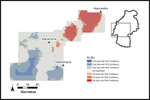
The results of optimised hot-spot analysis within the contiguous survey zone indicate that corrals and estancias both cluster around the city of Huancavelica and adjacent mercury mines (Figures 4 & 5). Estancia hot spots are concentrated in the upper reaches of the ‘Mercury Road’, which runs south-west from Huancavelica city. Corral hot spots are more broadly distributed, with a concentration running northwest-southeast, aligning with the corridor connecting Villa de Arma and Castrovirreyna, both major colonial period settlements. Corral and estancia cold spots are concentrated in the lower-elevation south-western and southern reaches of the zone. Hot-spot distribution indicates a relationship between pastoral infrastructure and major present-day and colonial period settlements.

Figure 4. Optimised hot-spot analysis of corrals (figure by the authors).

Figure 5. Optimised hot-spot analysis of estancias (figure by the authors).
We used zonal statistics to calculate mean NDVI and NDVSI values and elevation for hot spots, cold spots, and the contiguous survey zone, the results of which are presented in Table 1. Corral and estancia hot spots are of higher average elevation compared to the contiguous survey zone as a whole, while cold spots for these loci are of lower average elevation than the contiguous survey zone, mapping the highland focus of herding activity. Estancias have, on average, higher elevation hot spots compared to corrals, indicating that home bases are concentrated at higher elevations. Both corral and estancia hot spots have a lower average NDVI than the contiguous survey zone, whereas cold spots for these loci have a higher NDVI. While this could suggest that vegetation productivity is not a key factor determining corral or estancia location, results may be skewed by elevation. NDVI values tend to be lower at high altitudes and both corral and estancia hot spots have a high average elevation. Comparing NDVI values between higher and lower elevation regions could thus obscure high-elevation grazeland signals. In contrast, mean NDVSI values—based on the ratio between wet and dry season vegetation and thus not impacted by altitude—for corral and estancia hot spots are lower than for the cold spots and for the contiguous survey zone, indicating that access to perennial vegetation was influential in determining corral and estancia location.
Table 1. Elevation, NDVI and NDVSI values for corral and estancia hot spots and cold spots in comparison to values for the contiguous survey zone as a whole.

Location choice and vegetation quality
Zonal statistics demonstrate that corrals and estancias are located at higher mean elevations than randomly generated points, further supporting the high-elevation focus of pastoral activity (Table 2). Estancias have a higher mean elevation and smaller elevation range than corrals, indicating that they are more restricted to highland zones than corrals are. Estancias also have a higher mean NDVI than both corrals (p < 0.0001) and random points (p = 0.0483). Given that estancias are located at higher elevations than corrals, which should correlate with lower NDVI values, the fact that estancias have significantly higher NDVI values than corrals is striking.
Table 2. Elevation, NDVI and NDVSI values for corrals, estancias and random points (RP) over the entire survey area.

Corrals have the highest NDVSI value of all datasets, suggesting that corrals are not located to take advantage of perennial vegetation. This contradicts our previous finding that corral hot spots have a lower NDVSI value, which may be due to the broadening of our analysis beyond the contiguous survey zone. Estancias have a significantly lower mean NDVSI value than corrals (p = 0.00444) and a slightly lower but not significantly different mean NDVSI value than random points (p = 0.4320). Estancias are thus more likely to be located close to perennial vegetation than corrals, aligning with the identification of estancias as permanently occupied home bases which require year-round access to pasture. This finding supports conclusions drawn from estancia clustering data in the contiguous survey zone and extends them to the entire survey area.
Discussion
The large-scale data presented here—to our knowledge, the largest systematic survey of relict pastoralist infrastructure yet undertaken—provide strong support for the hypothesis that herders orient herding practices around bofedales. Following the approach of other researchers (e.g. Vining Reference Vining, Capriles and Tripcevich2016; Lane et al. Reference Lane2022), our findings assume broad equivalence between past and present Andean environments but it is important to consider the accuracy of this assumption and the potential impacts that environmental fluctuations may have had on herding ecologies.
Implications of clustering
Clustering analyses suggest that corrals and estancias are concentrated around important colonial and present-day settlements (Figures 4 & 5). This suggests that pastoralists were not exclusively oriented around bofedales and that their site location preferences were also mediated by regional political and economic dynamics. These findings emphasise the social and political embeddedness of land use practices in the past.
While it is challenging to date corrals, several lines of evidence suggest that growth in colonial period mining fostered an expansion of pastoral infrastructure in the area covered by our contiguous survey zone. Sixteenth- and seventeenth-century notarial records from Huancavelica document how the registration of mining claims was frequently accompanied by requests for land for crops and herds in the adjacent area. In 1591, for example, Gaspar de Ayala, a Huancavelica resident, gave authority to Juan Delgadillo and Lucas Rodriguez Mexia to petition the Viceroy for support for silver mines he owned close to Huancavelica. The requested support included labour allocations and land to build refinement infrastructure, houses for workers and, critically, fields for crops and livestock (Archivo Histórico de Huancavelica (AHH): 174–175, 6 March 1591).
Secondly, rural peoples moving to Huancavelica to labour in the mines, coercively or otherwise, often brought their families and herds with them (e.g. Smit Reference Smit2018: 89). Mitayos—workers conscripted by the mita labour draft, a colonial Andean system of rotating forced Indigenous labour in mines and refineries—often remained at the mines after their service had ended. While exact figures for Huancavelica are not known, only about 2000 of the 7000 who migrated annually from Chucuito, on the shores of Lake Titicaca, to Potosí in Bolivia returned home each year; the rest remained in Potosí (Lane Reference Lane2019: 78). Mining labour demands thus permanently swelled the populations of mining centres, which likely increased the demand for grazeland and pastoralist infrastructure in the area.
Finally, records from Huancavelica further indicate the persistent use of camelids in caravans, despite the introduction of non-native cargo animals (AHH: 3–5, 2 January 1578; see also Cobb Reference Cobb1949). The need to accommodate these animals likely spurred construction of corrals within the vicinity of the city. Notary records document the presence of corrals within city limits (AHH: 66v–67v, 22 April 1599), while others describe the construction of, or need for, corrals outside of the city proper (AHH: 174–175, 6 March 1591). These examples, coupled with survey evidence for denser concentrations of corrals and estancias in and around known colonial period centres, indicate that colonial period mining development impacted pastoral settlement patterns in Huancavelica.
Functional differences in pastoral infrastructure
Our data document variation in the distribution of corrals versus estancias in terms of pasture access, which is indicative of differences in activities practised at these locations and may relate to whether or not settings could support permanent occupation. Estancias have, on average, higher NDVI and lower NDVSI values than corrals and random points. This means that herders preferentially located estancias in areas with ready access to higher-quality, perennial pasture, supporting their identification as permanently occupied home bases. In contrast, corrals have the highest mean NDVSI of all four datasets (Table 2), suggesting their use was not dependent on year-round access to pasture. Corrals could have been used permanently or temporarily, with attendant differences in pasture requirements.
Variation in environmental context between corrals and estancias indicates that they may have been designed to suit the physiological needs of different camelid breeds. Llamas are hardier, more arid-tolerant and will travel up to a 5km round trip to reach pasture (Flores Ochoa Reference Flores Ochoa1979; Flannery et al. Reference Flannery, Marcus and Reynolds1989; Dransart Reference Dransart2002). Alpacas require more moisture, are almost exclusively grazed on bofedal pasture and tend not to stray far from home bases (Orlove Reference Orlove1977; Palacios Rios Reference Palacios Rios and Ochoa1988: 88; Dransart Reference Dransart1991; Postigo et al. Reference Postigo, Young and Crews2008). Estancias are well-suited to the needs of alpacas, who are spatially tethered to bofedales. Such locales would also accommodate llamas, although when bofedales are scarce, alpacas are usually afforded preferential access (Dransart Reference Dransart2002: 44). Corrals vary more substantially in their environmental setting. Some corrals have sufficient access to pasture to support alpacas, while others were likely restricted to use by llamas. Some of this variation likely stems from the diverse locations in which corrals are found; some are located adjacent to settlements and contain large numbers of corrals, whereas others are remote and isolated.
These differences perhaps point to variation in Andean herding practices. While pre-Hispanic Andean pastoralism is often glossed as a single strategy, it really includes two parallel orientations: caravanning and fibre production. Llamas are more frequently associated with caravanning, and alpacas with fibre production. Our findings that corrals and estancias had differential pasture access suggests that different animal uses are reflected in the material record of Andean pastoralism. Herding communities incorporated knowledge about animal needs and environmental conditions into construction decisions.
Perennial vegetation and land-cover change
Previous data identify bofedales as perennial vegetation, with researchers noting that bofedales are valuable resources precisely because they provide year-round pasture (Chimner et al. Reference Chimner2020: 251; White-Nockleby et al. Reference White-Nockleby, Prieto, Yager and Meneses2021: 102; Lane et al. Reference Lane2022: 2). Our data support this, indicating that bofedales in Huancavelica provide perennial pasture and that pastoral infrastructure is located to take advantage of these resources. But variation in corral location suggests regional and local variation in the importance of perennial vegetation and possibly inter-annual fluctuations in bofedal extent and vigour.
Bofedal use varies regionally depending on the broader environmental context. In Suches, Department of Tacna, extremely arid conditions mean that herders rely on bofedales year-round (Vining Reference Vining, Capriles and Tripcevich2016), whereas wetter conditions in the upper Ica drainage in Huancavelica mean that herders only need to use bofedales during the dry season (Lane et al. Reference Lane2022: 2). Our dataset documents the occasional presence of corrals in areas without access to bofedales, suggesting that herders in Huancavelica would not have had to rely on bofedales year-round, consistent with the findings of Lane and colleagues (Reference Lane2022). Inter- and intra-regional variation in environmental conditions could thus go some way towards explaining differential pasture access.
Our findings assume bofedales are inter-annually stable, which follows assumptions in other research regarding broad equivalence between past and present environments (Vining Reference Vining, Capriles and Tripcevich2016; Lane et al. Reference Lane2022). Researchers have argued that vegetation flux in response to short-term climatic change is broadly constant, meaning that present-day cover provides an appropriate analogue for past conditions (Vining Reference Vining, Capriles and Tripcevich2016: 104). Bofedal extent and vigour are, however, impacted by climatic shifts at different scales. Today, deglaciation, along with irregular and unpredictable rainfall, threatens the groundwater supplies upon which bofedales rely (Yager et al. Reference Yager, Prieto and Meneses2021: A5). Similarly large-scale climatic shifts in the past, evidenced in ice core records (e.g. Thompson et al. Reference Thompson, Moseley-Thompson, Bolzan and Koci1985) may have impacted bofedal prevalence.
On a smaller scale, Baitzel and colleagues (Reference Baitzel, Polo y La Borda, Konecky, Sae-Lim and Rivero Infante2022), in a discussion of high-altitude herder residences, note how glacial expansion may have periodically rendered the estancia in question inaccessible. This serves as a reminder that past Andean environments may have fluctuated on a timescale short-term enough to render even home bases periodically inaccessible during their use-life. The importance of bofedales to herders likely varied depending on prevailing environmental conditions. In years with high precipitation, bofedales may have been less important for herders as other vegetation was widely available. Conversely, in drier periods access to bofedales would have become much more important as other pasture became scarce. Consequently, there were likely periods in which herders were more—or less—reliant on bofedales due to shifting environmental conditions, with concomitant impacts on settlement patterns and pastoral practices.
Conclusions
In this study, we used satellite imagery data and vegetation indices to examine regional and trans-regional trends in the location and environmental context of herding infrastructure in Huancavelica, Peru. Our analyses resulted in two primary findings. First, that there are denser concentrations of corrals and estancias around major colonial and present-day settlements than in other locations within the study area. With support from archival evidence, we interpret this pattern as indicative of colonial period influences on pastoralist settlement preferences. Second, we found that estancias had higher NDVI and lower NDVSI values, meaning that they are preferentially located close to productive, perennial vegetation. Corrals, in contrast, were found in diverse environmental contexts. We suggest that this may reflect the differing physiological needs of llamas and alpacas, which in turn indicates that the material signatures of caravanning and fibre production may be different. Finally, we considered the impact of environmental change and fluctuations on bofedal prevalence, concluding that small-scale past fluctuations likely affected the extent to which herders relied on bofedales, with implications for pastoral settlement patterns and practices.
Acknowledgements
We are grateful to the other members of the south-central Andes survey team, including Douglas Smit, Natali López Aldave, Makoto Kobayashi, Scotti Norman and Sophie Blumenstein. We are also grateful to Douglas Smit for providing us with access to notarial records from Huancavelica. Three anonymous reviewers provided valuable feedback on how to improve the article. Any errors remain our own.
Funding statement
The development of the GeoPACHA platform was funded through an American Council of Learned Societies Digital Extension Grant: Extending GeoPACHA: Geospatial Platform for Andean Culture, History, and Archaeology, awarded to Steven A. Wernke, PI and Parker VanValkenburgh, Co-PI. Initial development of GeoPACHA was supported by a National Endowment for the Humanities Level II Digital Humanities Startup Grant (Grant HD-229071-15) and a Center for Advanced Spatial Technology (CAST) Spatial Archaeometry Research Collaborations (SPARC) grant. Further support for virtual survey and analysis was provided in part via an International Dissertation Research Fellowship from the Social Science Research Council, awarded to Bethany Whitlock.
Archival abbreviations
AHH: Archivo Histórico de Huancavelica, Huancavelica, Peru. Further information is available via the government record of the archive at: https://mapapape.agn.gob.pe:8081/agn-pape/huancavelica


 Open access