


The differential distribution of wealth is commonplace within both pre-modern and industrial societies throughout the globe (Dow and Reed Reference Dow and Reed2013; Milanovic et al. Reference Milanovic, Lindert and Williamson2011). However, these inequalities are not inherently restricted to any social organization, political structure, economic system, or environment, and modeling the degree of such phenomena across space requires a complex comprehension of past populations and their connections with the material world (Ames Reference Ames, Bentley, Maschner and Chippindale2007; Peterson and Drennan Reference Peterson, Drennan, Smith and Kohler2018). In the past decade, Mesoamerican researchers have increasingly adopted quantitative methods to understand wealth differential within the archaeological record, including measures such as the Gini coefficient (Strawinska-Zanko et al. Reference Strawinska-Zanko, Liebovitch, Watson, Brown, Strawinska-Zanko and Liebovitch2018).
This article presents preliminary research from household-derived Gini coefficients obtained from Late and Terminal Classic (ca. a.d. 700–900) Las Cuevas, Belize. Situated approximately 14 km southeast of the urban core of Caracol, the Las Cuevas region offers a unique case study to compare wealth inequalities between two political centers of differential scale and historical trajectories. Furthermore, because Las Cuevas was occupied only for a brief period in the Late and Terminal Classic, the area is well-suited to model the potential effects of occupational length on the severity of differential wealth distribution across the Maya Lowlands (Moyes et al. Reference Moyes, Robinson, Kosakowsky, Voorhies, Guerra, Galeazzi and Ramos2012). Additionally, because populations associated with Las Cuevas appear to have invested heavily in cave-based ritual and the construction of subterranean ritual space, the region offers the opportunity to explore wealth differentiation not only in connection to variation in residential group size, but also in relation to proximity to these important and potentially valuable underworld places. This research, in collaboration with other researchers within the Spatial Analyses of Maya Settlements (SAMS) collective, seeks to generate Gini coefficients and Lorenz curves to compare wealth differences within Maya society. Our results, processed on local, inter-polity, and regional scales, indicate a moderately high degree of wealth inequality comparable to other Maya centers occupied in the Classic period with reported Gini coefficients.
Background
The Las Cuevas-Monkey Tail settlement area, situated within the Chiquibul Forest Reserve of western Belize, straddles the southeastern edge of the Vaca Plateau. Low modified hills, constricted valleys, steep-sided ridges, and minimal-relief, seasonally inundated depressions (pocket bajos) are common throughout the landscape (Figure 1). To the east, the Raspaculo and Macal drainages form a sharp divide between the karstic plateau and the metamorphic and granitic materials exposed throughout the Maya Mountains (Bateson Reference Bateson1972). Slopes throughout the area have been stabilized through the expansive construction of masonry terraces, and ditched field systems have also been recently documented in bottomlands on the northern and southern peripheries of the study area (Montgomery Reference Montgomery, Moyes and Ray2019). Two centers of roughly equal size, Las Cuevas and Monkey Tail, likely serviced much of the population in this portion of the plateau (Figure 2), although eight additional minor civic-ceremonial centers have also been identified within the study area. Las Cuevas represents a unique example of the direct integration of surface architecture with an expansive cave system, suggesting a dual ritual and civic role (Moyes Reference Moyes, Houk, Arroyo and Powis2020; Moyes et al. Reference Moyes, Robinson, Voorhies, Kosakowsky, Arksey, Ray and Hernandez2015). Limited excavation and mapping at Monkey Tail, 3 km to the east, suggests that the center was comparable in size, function, and importance during these periods (Ramos Reference Ramos, Moyes and Robinson2013:114).
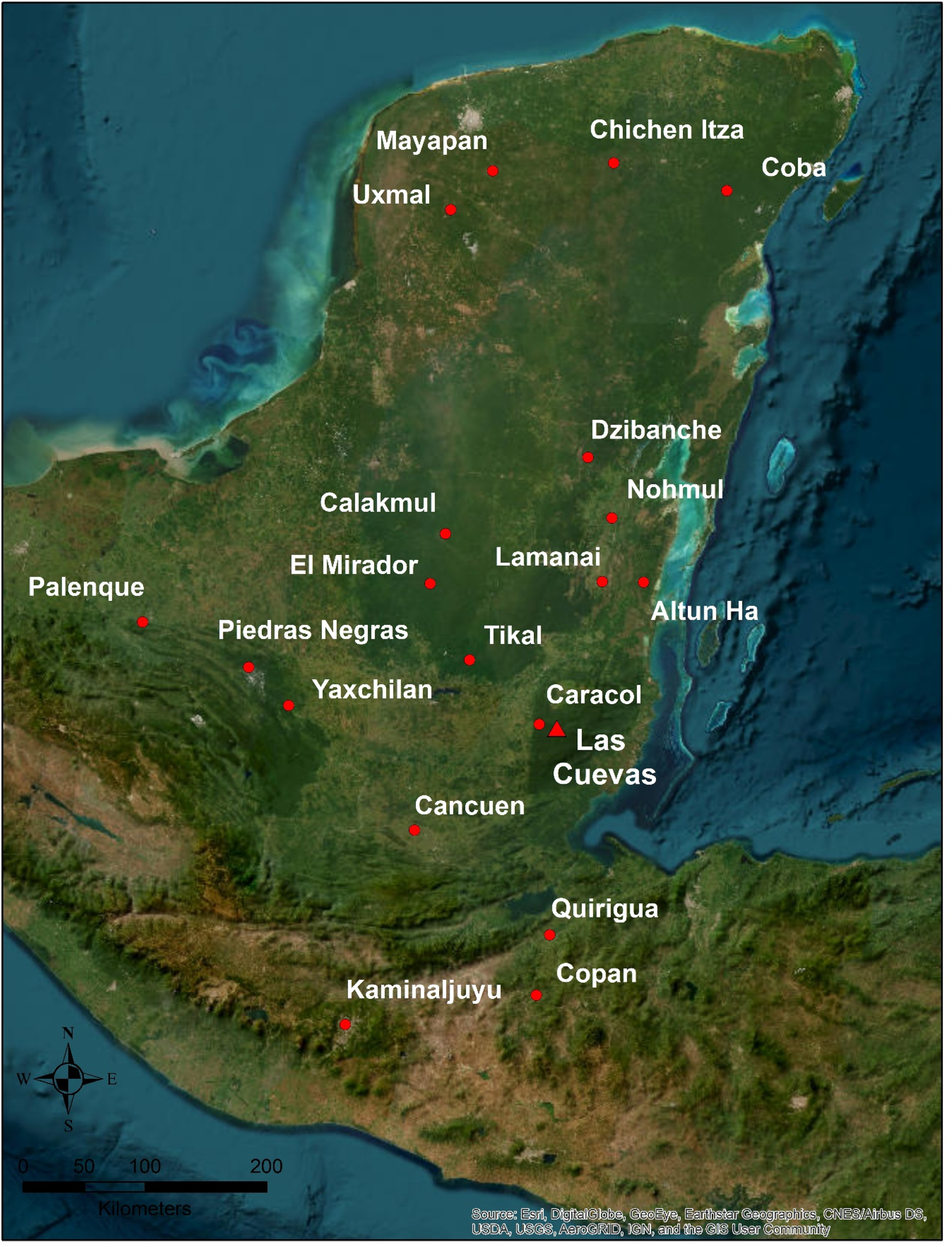
Figure 1. Las Cuevas project area overview. Source: Esri, DigitalGlobe, GeoEye, Earthstar Geographics, NCES/Airbus DS, USDA, USGS, AeroGRID, IGN, and the GIS User Community.
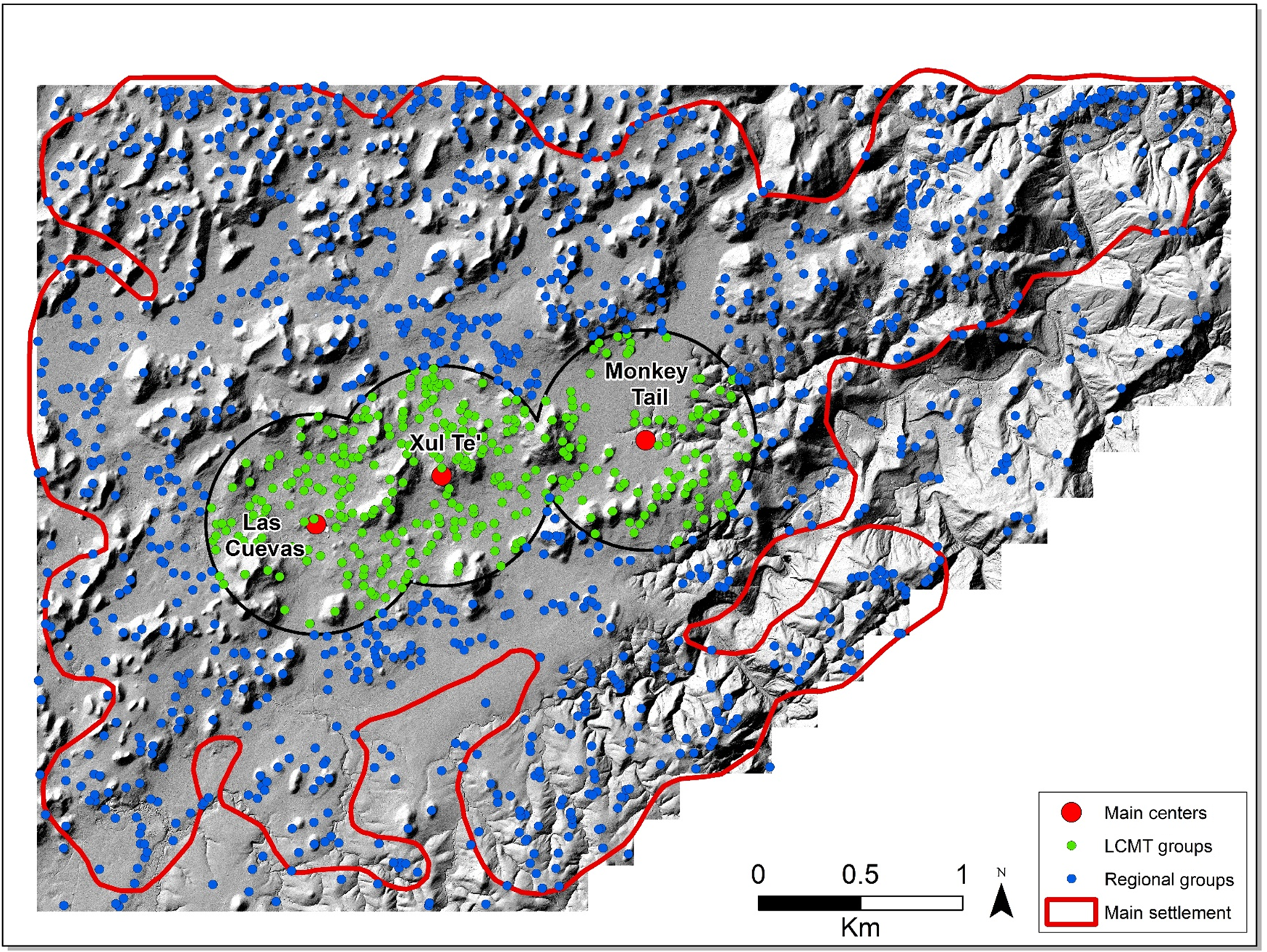
Figure 2. Distribution of Las Cuevas residential groups. Map by Montgomery.
The Las Cuevas Archaeological Reconnaissance Project (LCAR) began in 2011 to better understand Las Cuevas’ role as a potential pilgrimage site during the final centuries of the Classic period (Moyes et al. Reference Moyes, Robinson, Kosakowsky, Voorhies, Guerra, Galeazzi and Ramos2012, Reference Moyes, Robinson, Voorhies, Kosakowsky, Arksey, Ray and Hernandez2015). After over a decade of research at the site of Las Cuevas, evidence indicates that the center served as an important ritual locale for local populations and may have acted as a preeminent multiregional pilgrimage site during the Late and Terminal Classic periods (Moyes Reference Moyes, Guderjan and Matthews2023). What remains less clear is how Las Cuevas articulated and interacted with other ritually utilized caves in the vicinity. In addition to Las Cuevas, nine other caves have been identified in the study area with moderate to high amounts of cultural materials and architecture, indicating ritual use of these subterranean spaces (Montgomery Reference Montgomery, Moyes and Ray2019), and five of these are associated with minor centers with formal plazas and non-residential architecture (Moyes and Montgomery Reference Moyes and Montgomery2016, Reference Moyes and Montgomery2019). While past studies in the Maya Lowlands have utilized Gini coefficients to assess wealth inequalities within larger cities (Chase Reference Chase2017), smaller cities (Hutson and Welsh Reference Hutson and Welch2021), or within cities through neighborhoods (Thompson et al. Reference Thompson, Feinman and Prufer2021a, Reference Thompson, Feinman, Lemly and Prufer2021b), no similar studies have been produced that consider the effects of alternative focal nodes such as caves. Beyond seeking to understand how potential wealth inequality was manifested within the region and in areas of highest population densities between the centers of Las Cuevas and Monkey Tail, the following investigations also considered how these inequalities might relate to proximity to these culturally significant cave systems.
Caves form an important part of the archaeological record, as they are often sheltered or protected from destructive environmental or taphonomic processes, and contain an abundance of information owing to their deep stratigraphic deposits and excellent preservation (Moyes and Brady Reference Moyes, Brady and Moyes2012). Among many past indigenous populations throughout the Americas, caves reified important ideas concerning cosmology, ritual, and political order (Ashmore Reference Ashmore, Hanks and Rice1989; Ashmore and Sabloff Reference Ashmore and Sabloff2002). To the ancient Maya, who made use of these subterranean spaces for ritual purposes as early as 1200 b.c. (Moyes et al. Reference Moyes, Kosakowsky, Ray and Awe2017), caves were a substantial part of a three-tiered cosmological model associated with the mountain/cave/water complex (Brady and Ashmore Reference Brady, Ashmore, Ashmore and Knapp1999). These natural features were not only considered entrances to the Maya underworld, but also the abode of numerous deities connected with the earth, fertility, rainmaking, maize, and ancestral entities (Brady and Prufer Reference Brady, Prufer, Brady and Prufer2005; McAnany Reference McAnany1995).
Because of these culturally significant associations, ancient Maya rulers attempted to link themselves to these powerful cosmological forces through the incorporation of natural landscapes into monumental layouts or the construction of artificial caves within site centers (Moyes Reference Moyes2006). Previous researchers (Farriss Reference Farriss1984; García-Zambrano Reference García-Zambrano, Robertson and Field1994) have noted that the presence of caves, particularly those associated with life-giving water, can impact the selection of the original settlement, or define geographic or political boundaries (Moyes and Prufer Reference Moyes and Prufer2013). The cosmological symbolism is clearly apparent in the site layout of Las Cuevas, which features one of the most well-developed architectural elaborations of any cave site in the Maya Lowlands, including numerous plaster platforms, masonry walls, and constructed blockages (Moyes and Montgomery Reference Moyes and Montgomery2016). Similar trends in the connection between ritual cave use and the location of minor centers within the Las Cuevas study area is apparent at the surface sites of Cahal Xux and Ox Tun, which are directly associated with the caves K'in K'aba and Z'uhuy Ch'en (Montgomery Reference Montgomery, Moyes and Ray2019).
While most Late and Terminal Classic centers within the Las Cuevas study area show an active intent to link themselves to and control these subterranean spaces, it remains less clear how households from the same period may have been impacted by proximity to cave sites, especially during the prolonged droughts of the ninth and tenth centuries and their subsequent impacts on regional political systems (Moyes et al. 2009). As cave sites became increasingly important in an attempt to alleviate drought conditions, those households adjacent to these special places may have been primed to benefit from the control of access to such spaces, or profited as ritual performers overseeing communal or individual activities at these subterranean locations (Moyes Reference Moyes2006; Prufer Reference Prufer2002). These benefits may have been transformed into various sources of material and immaterial wealth, including increased access to labor for household construction. Determining the potential wealth differentials between cave-adjacent households and the larger regional sample represents the key application of Gini analysis within this article and is discussed further in the following sections.
Materials and methods
Various quantitative parameters have been used to model inequalities within prehistoric Maya populations, including material richness, densities of utilitarian items, mortuary variability, and adjusted health indices (Munson and Scholnick Reference Munson and Scholnick2021; Schulting Reference Schulting1995). Here, we focused on material wealth in the form of residential structures and their basic physical attributes (Feinman et al. Reference Feinman, Faulseit, Nicholas, Smith and Kohler2018). To assess wealth inequality in the Las Cuevas region, surface area (m2) and volume (m3) were extracted from plazuelas identified through a combination of LiDAR-derived visualizations and pedestrian survey methods. To account for those structures that may not have served primary residential functions, individual constructions below 20 m2 and over 275 m2 were removed from all samples (see Thompson et al. Reference Thompson, Chase and Feinman2023).
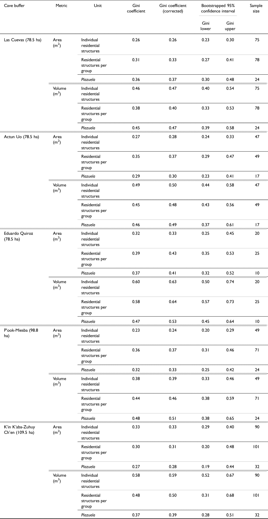
The larger Las Cuevas study area (95.25 km2) contained 1,657 plazuelas supporting 4,307 visible superstructures. A more focused, smaller scale of analysis, referred to as the Las Cuevas-Monkey Tail (LCMT) corridor, represented a 12.25 km2 area of higher settlement density dispersed between the two paramount centers of the region. The LCMT corridor was generated using overlapping 1.2 km buffers around the centers of Monkey Tail, Xul Te', and Monkey Tail (Figure 2). A total of 355 plazuelas and 1,073 structures were included within the corridor, representing 21.4 percent of all households within the region. Lastly, 500 m buffers were created around seven of the most highly utilized caves within the study area (Las Cuevas, Actun Uo, Eduardo Quiroz, Actun P'ook, Actun Miesba, K'in K'aba, and Z'uhuy Ch'en), including two “binary” systems found in close proximity to each other and with substantial overlap (P'ook-Miesba and K'in K'aba-Z'uhuy Ch'en). These buffers ranged in area from 0.79 to 1.1 km2 and contained between 10 and 32 plazuelas (Figure 3). Combined, 107 plazuelas in close proximity to ritually utilized cave spaces were subjected to Gini analyses, representing 6.5 percent of all identified households within the Las Cuevas area.
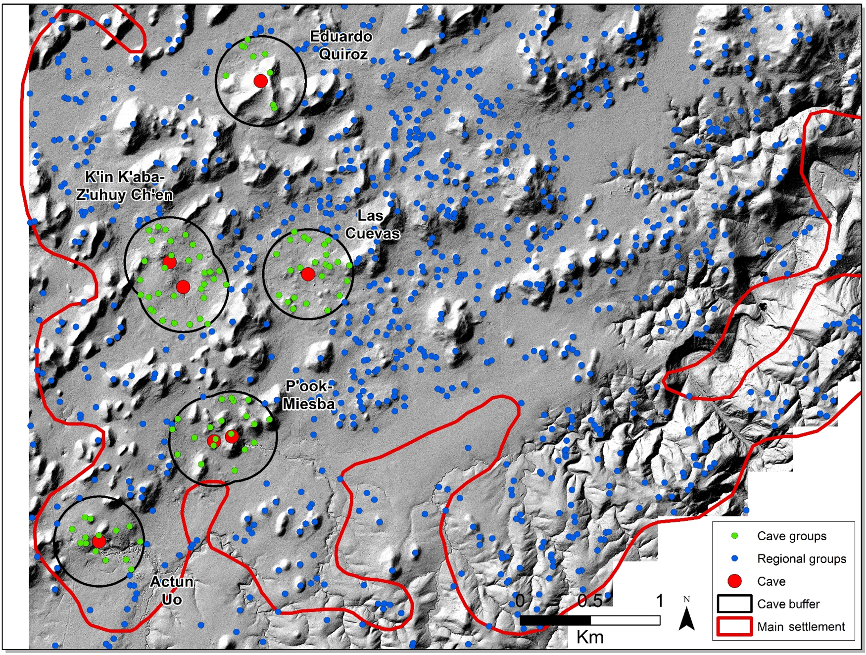
Figure 3. Overview of cave-adjacent residential groups. Map by Montgomery.
Based on previous studies (see Thompson et al. Reference Thompson, Feinman and Prufer2021a), and with the goal of generating additional comparative datasets across the Maya Lowlands, three units of analysis were utilized: (1) individual residential structures (e.g., Hutson and Welch Reference Hutson and Welch2021); (2) combined structures in plazuela (e.g., Thompson et al. Reference Thompson, Feinman and Prufer2021a, Reference Thompson, Feinman, Lemly and Prufer2021b); and (3) entire plazuela (e.g., Chase Reference Chase2017). Maximum extents for each plazuela and associated superstructures were digitized as polygons within the LCMT corridor and cave buffers using ArcGIS Pro 2.9. Due to the large sample size of residential structures, only plazuela groups were digitized for the larger Las Cuevas region. Structure and plazuela areas were obtained through the Calculate Geometry function, while volume calculations were run using a custom Python script provided by Chase and colleagues (Reference Chase, Thompson, Walden and Feinman2023), building on existing methodologies (Chase Reference Chase2017; Ebert et al. Reference Ebert, Hoggarth and Awe2016; Šprajc et al. Reference Šprajc, Marsetič, Štajdohar, Góngora, Ball, Olguín and Kokalj2022; Stanton et al. Reference Stanton, Ardren, Barth, Fernandez-Diaz, Rohrer, Meyer, Miller, Magnoni and Pérez2020). Lorenz curves and Gini coefficients (raw and corrected) were computed for each of the three units of analysis in Excel and R, based on Shryock and Siegel (Reference Shryock and Siegel1976), and a bootstrapping procedure was used to find the 95 percent confidence interval for the generated data (see Chase et al., Reference Chase, Thompson, Walden and Feinman2023).
Results
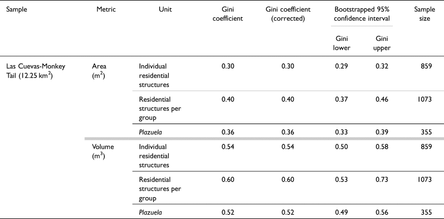
Gini coefficient results from the larger Las Cuevas region, the LCMT corridor, and the cave-adjacent sample indicate moderately high levels of wealth inequality as measured through spatial metrics (Figures 4 and 5), consistent with findings reported at other Classic period Maya sites such as Caracol (Chase Reference Chase2017), Uxbenká/Ix Kuku'il (Thompson et al. Reference Thompson, Feinman and Prufer2021a), and Nim li Punit and Muklebal Tzul (Thompson et al. Reference Thompson, Feinman, Lemly and Prufer2021b). Corrected Gini coefficients were determined for all categories. These corrected values differed from raw values only within smaller samples such as those associated with individual cave buffers, resulting in modest increases in coefficient values between 0.01 and 0.06. Corrected Gini coefficients are listed here unless otherwise noted. Within the LCMT corridor (Table 1), the highest Ginis were correlated with combined structural volume per group (0.60), individual residential structural volume (0.54), and plazuela volume (0.52). Area Gini coefficients were calculated at 0.40 (combined structural area), 0.36 (plazuela area), and 0.30 (individual residential structural area).
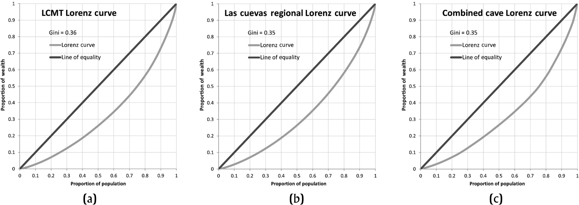
Figure 4. Lorenz curves for residential group area (m2): (a) LCMT corridor (n = 355); (b) Las Cuevas (n = 1,657); (c) combined cave (n = 107). Figures by Montgomery.
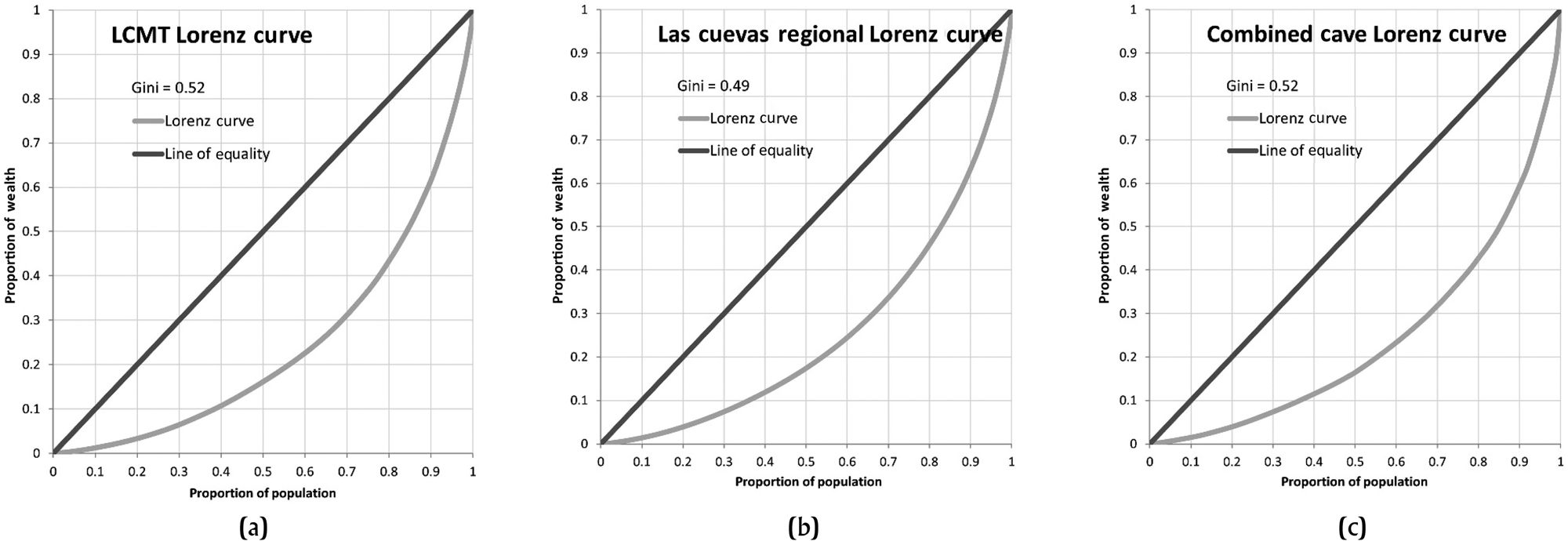
Figure 5. Lorenz curves for residential group volume (m3): (a) LCMT corridor (n = 355); (b) Las Cuevas (n = 1,657); (c) combined cave (n = 107). Figures by Montgomery.
Table 1. Gini coefficient results, Las Cuevas-Monkey Tail corridor
Within the collective cave-adjacent household sample (Table 2), coefficients were highest for individual residential structural volume (0.54), followed closely by plazuela volume (0.52), and combined structural volume per plazuela (0.52). Area Gini coefficients were slightly lower than those generated for the LCMT corridor, calculated at 0.38 (combined structures), 0.36 (plazuelas), and 0.31 (individual residential structures). Eduardo Quiroz produced the highest coefficient values (individual residential structure volume: 0.63; combined structural area: 0.43) for any single buffer (Table 3). The K'in K'aba-Z'uhuy Ch'en buffer generated the lowest GI values for volume (plazuela volume: 0.39), while the P'ook-Miesba coverage offered the lowest area Gini coefficient values (individual residential structures: 0.24).
Table 2. Gini coefficient results, combined cave-adjacent households
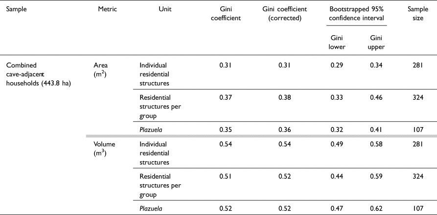
Table 3. Gini coefficient results, individual cave buffers
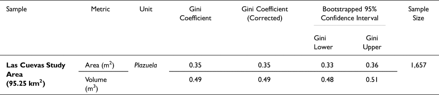
While structural Gini coefficients were not generated for the total number of residential structures within the larger Las Cuevas region, aggregate plazuela values for the entire 92.25 km2 study area were comparable to the LCMT in area (0.35) and volume (0.49) (Table 4). When assessed against the combined cave-adjacent household sample, plazuela area shared identical coefficient values. It is interesting to note that the plazuela area values from the Las Cuevas region agree closely with those reported for sampled Caracol households (Chase Reference Chase2017:Table 2), while volumes for those same plazuelas are substantially higher at Caracol. A similar tendency was noted by Thompson and colleagues (Reference Thompson, Feinman and Prufer2021a:Table 2) based on Gini coefficients obtained for the Uxbenká and Ix Kuku'il centers.
Table 4. Gini Coefficient Results, Las Cuevas Region
Discussion and interpretations
The Gini coefficients reported for the Las Cuevas area correspond with values previously reported throughout the Maya Lowlands and fit with median Gini coefficients attributed to pre-modern agricultural (Smith et al. Reference Smith, Mulder, Bowles, Gurven, Hertz and Shenk2010:Figure 4) and -state level societies (Kohler et al. Reference Kohler, Smith, Bogaard, Feinman, Peterson, Betzenhauser, Pailes, Stone, Prentiss, Dennehy, Ellyson, Nicholas, Faulseit, Styring, Whitlam, Fochesato, Foor and Bowles2017:Figure 2). Gini coefficients generated from the smaller LCMT and cave-adjacent residential samples display higher coefficient values for plazuela areas and volumes compared to the total residential groups in the region, even though the Gini statistic exhibits a significant small-sample bias, especially when such a coefficient is used to compare inequality across subpopulations (Deltas Reference Deltas2003:226–227). In agreement with Peterson and Drennan (Reference Peterson, Drennan, Smith and Kohler2018:49), the Gini coefficients reported for these above and below ground-central places are considered maximal estimates, containing higher proportions of wealthier, higher-prestige, or more productively differentiated households than did outlying settlements. Increased Ginis may relate to higher average residential areas and volumes within these smaller samples. Average residential areas within the LCMT and cave-adjacent samples were between 19 and 21 percent higher compared to the entire region, and average residential volumes for these smaller samples showed a 19–30 percent increase over the regional trends. This may suggest that populations in closer proximity to the three LCMT centers and/or ritually utilized caves either enjoyed higher access to household labor or possessed a longer occupation than those residents living further to the south and east. Additional excavations are needed to differentiate between these two potential processes.
The relationship between Gini-modeled residential wealth differential and proximity to caves in the study area remains ambiguous, especially concerning whether such households benefited directly in the form of access to local labor. While caves such as Las Cuevas, K'in K'aba, and Z'uhuy Ch'en were clearly integrated with surface sites, others, including Eduardo Quiroz, were not incorporated in this manner, despite water-related characteristics and ritual use during the Late and Terminal Classic (Pendergast Reference Pendergast1971). This suggests that other variables, such as geographic or political boundaries, influenced the co-optation of these spaces, both by households and by larger social entities. Alternatively, plazuelas near ritually important caves may have amassed wealth from either indirect involvement or active participation in related rituals, but in forms other than access to household labor. For example, excavations conducted in 2019 at the nearest plazuela to Eduardo Quiroz revealed an early Late Classic burial associated with a jade pectoral bearing the Maya ik' or wind sign (Moyes et al. Reference Moyes, Alsgaard, Ray and Kosakowsky2023). While such exotic finds are usually connected to elite or royal contexts in the Maya Lowlands (Braswell Reference Braswell2017), this pectoral was recovered from an unimposing eastern structure in an architecturally modest household. Further excavations at other cave-adjacent plazuelas may reveal additional variations in material wealth not directly translated into household size.
Preliminary results indicate that variations in plazuela area and volume illustrate higher levels of wealth differential within the Las Cuevas region, and we look forward to data comparisons between our values and those generated by other SAMS members, especially those working in areas that have a more developed Preclassic or Postclassic settlement component. However, even with mathematical modeling and determinations of statistical confidence, Gini coefficients should be bolstered by other analytical methods when explaining variation in household area and volume. Primarily, Gini coefficients are poorly suited to discern structural changes over time. Within modern nations or social groups, this relates to the proportion of younger and older members of society and how wealth is distributed in association with age (Chuen Reference Chuen2010). Within this study, the distributional composition is more accurately impacted by the age or longevity of the household structure (Abrams Reference Abrams1994). Without additional information obtained through excavation, Gini analyses cannot differentiate between high volume households that resulted from normal accretionary processes and those that commanded a high amount of labor input over a short period of time (Hutson Reference Hutson2016:151–152).
While the expression of material wealth in connection with increased access to labor may hold true across much of the study area, differences in household extent and volume are also influenced by local topography, resource differentiation, and access to construction materials (Stanton et al. Reference Stanton, Ardren, Barth, Fernandez-Diaz, Rohrer, Meyer, Miller, Magnoni and Pérez2020). Even with the use of nearest neighbor interpolation to digitally model the vacant landscape prior to Classic period landscape modification, volume estimates are likely overestimated in association with hillside and hilltop residential units, which may incorporate natural landform elements, both as labor-saving mechanisms and integration with the natural landscape. Future research will integrate Gini values with other parameters (slope, aspect, visibility, landform unit, soil type and depth, drainage, etc.) to understand potential positive and negative correlations through statistical spatial models such as geographically weighted regression (GWR). However, as a preliminary step towards understanding residential architectural variation in Classic Maya society, Gini coefficients are well-positioned to highlight similarities and differences between the heterogeneous landscapes of the Lowlands.
In conclusion, the application of the Gini index to residential areal and volumetric data within the Las Cuevas region has led to the identification of variation within all samples analyzed, suggesting moderate to high levels of social inequality within the Late and Terminal Classic population. These differences increased when considering those households in closer proximity to primary centers and/or ritually utilized caves. However, overall variation within observed Gini coefficients for all three groups was minimal, signaling that these differences may relate to biases in sample size or other factors beyond those related to architectural volume. Regardless of the efficacy of Gini indices in explaining household inequalities within ancient Maya populations, the technique has served as a path to reach higher conversations concerning the deeper meaning of inequality within past societies, including the biases inherent in our own conceptualizations of wealth and egalitarianism.
Acknowledgments
We would like to thank the Belize Institute of Archaeology for its continued support, particularly to John Morris and newly appointed Director of Archaeology Melissa Badillo for permitting our research. We are grateful to all those who aided in past seasons of residential and cave survey, particularly our in-country partners.
Competing interests declaration
The authors declare that they have no known competing financial interests or personal relationships that could have appeared to influence the work reported in this article.
Data availability statement
The data that support the findings of this study are available on request from the corresponding author. Some data are not publicly available due to restrictions associated with the sharing of locational data of cultural resources within the country of Belize.
Funding statement
Funding for the LiDAR-based residential and cave survey was made available from the Alphawood Foundation to the Western Belize LiDAR Consortium. The data on which the majority of the Gini coefficient research relied were supported by grants to Moyes from the National Geographic Society (#9544-14, GR-000000589), the University of California, Merced, and the Alphawood Foundation.


 Open access