

Abstract
Roadside air pollution is one of the serious air pollution problems in urban areas. Even though roadside air pollution has been reported to cause adverse human health impacts, the spatial distribution of roadside air pollution in a large urban agglomeration has yet to be fully assessed. This study aimed to analyse roadside fine particulate matter (PM2.5) pollution and the population exposure in 11 cities in the Pearl River Delta (PRD) region of China. We developed satellite-retrieval algorithms with dark target method, vector support machine model and random forest model to retrieve the spatial distribution of PM2.5 at an ultra-high-spatial-resolution (30 m) based on 30 m Landsat-8 L1 data. Our results show that the retrieved PM2.5 had a promising consistency with PM2.5 measurements at general and roadside stations (R2 = 0.86; RMSE = 7.72 µg m−3). Moreover, on average, the roadside PM2.5 in Dongguan, Foshan, and Guangzhou was relatively higher (up to 107.60 µg m−3) whereas that in Hong Kong was relatively lower (up to 30.40 µg m−3). The roadside PM2.5 pollution typically occurred in roads for motorized vehicles i.e. motorway, trunk, primary and secondary road. Our results also show that roadside PM2.5 was up to 17% higher in holidays than in workdays in all the PRD cities except Hong Kong that showed roadside PM2.5 higher in workdays than in holidays. The population-weighted PM2.5 decreased with increasing distances from roads in every PRD city, and population-weighted PM2.5 was estimated to be up to 22% higher at roadsides than at distances of 1500 m away from roads. This study pinpointed the seriousness of roadside air pollution in the PRD region.
Export citation and abstract BibTeX RIS

Original content from this work may be used under the terms of the Creative Commons Attribution 4.0 license. Any further distribution of this work must maintain attribution to the author(s) and the title of the work, journal citation and DOI.
1. Introduction
Particulate matter with an aerodynamic diameters ⩽2.5 μm (PM2.5) has been reported to be associated with health outcomes such as cardiovascular and respiratory diseases (Yim and Barrett 2012, Yim et al 2015, 2019b, 2022, Yang et al 2019, Gu et al 2020, Gong et al 2021). It is estimated that ambient air pollution caused 4.2 million premature deaths every year (Landrigan 2017). Air pollution has become a critical environmental problem especially in urban areas. This calls for urgent actions to address the problem for protecting population health.
Roadside PM2.5 pollution and the resultant population exposure are major challenges in urban areas (Masiol et al 2017, Tong et al 2020, Wang et al 2020a). The difficulties to mitigate roadside PM2.5 pollution are due to the substantial air pollutant emissions at roads and the complex surrounding physical environment. The emission sources along roadside comprise not only out-of-pipe exhaust emissions from vehicles but also non-exhaust particulate emissions from wear of tires, breaks, and road surfaces (Harrison et al 2021, Meng et al 2021, Zhou et al 2021, Fussell et al 2022). Moreover, building morphology in urban areas can reduce air ventilation along roadside, weakening air pollutant diffusion and trapping them within street canyons (Chan et al 2001, Kurppa et al 2018, Voordeckers et al 2021, Wang et al 2021). The complexity of roadside PM2.5 pollution requires high-spatial-resolution-data to represent sufficient spatial scale for detailed analyses. Furthermore, assessing population PM2.5 exposure requires to resolve PM2.5 down to at least the road level in a city (Donkelaar et al 2015, Saraswat et al 2016, Wang et al 2019, 2022, Li et al 2021, Huang et al 2023). Roadside PM2.5 measurements are typically sparse because of the limited space along roadside, low level of security for equipment installation and operation, and high cost of measurements, etc. The spatial distribution and population exposure of roadside PM2.5 pollution on the city scale therefore cannot be fully evaluated.
Roadside PM2.5 concentration can be measured by roadside stations and mobile sensors (Chen et al 2019, Suleiman et al 2019, Wadlow et al 2019, Xing et al 2019, Li et al 2020, Mukherjee et al 2020, Kakarla et al 2021, Afotey et al 2022), or simulated by atmospheric dispersion models (Tong et al 2020, Zhang et al 2022). Evaluating air pollution in a large urban agglomeration requires a certain level of spatial coverage. Remote sensing offers an alternative option such as Moderate Resolution Imaging Spectroradiometer (MODIS) (Lyapustin and Wang 2018), Advanced Himawari Imager (Yoshida et al 2018), Visible Infrared Imaging Radiometer Suite (Hsu et al 2019), and Landsat-8 Operational Land Imager (OLI) (Kaufman et al 1997a, Hsu et al 2006, 2013, 2017, Mhawish et al 2017, Yang et al 2018, 2022, Jin et al 2021, Tang et al 2021). To the best of our knowledge, remote sensing has not yet been adapted in roadside PM2.5 analyses due to its coarse spatial resolution that was not fine enough for detailed roadside air pollution studies. One of the technological challenges for urban air pollution application is the Aerosol Optical Depth (AOD) retrieval for urban areas with a high radiance. This kind of challenge limited the further applications of satellite-retrieval approaches to roadside air pollution analyses.
This study aimed to assess the characteristics of roadside air pollution and the population-exposure in the Pearl River Delta (PRD) region (a large urban agglomeration with 11 cities) during 2014–2022 under clear sky conditions. We developed algorithms combined with the dark target (DT) method and machine learning to retrieve ground-level PM2.5 in the PRD region based on Landsat-8 at a 30 m spatial resolution. We hence analysed the roadside PM2.5 pollution in different cities and road types in the PRD region, evaluated the holiday and weekday characteristics and also estimated the population-exposure as a function of distance in different cities.
2. Materials and method
This study focused on analysing the roadside PM2.5 in the PRD region, which is one of the most-developed urban agglomeration in China with a high population density, gross domestic product, and highway congestion index (Lang et al 2018, Hui et al 2020, Lin et al 2022). Despite significant efforts on air pollution control, the PRD region is still one of the major continental PM2.5 source regions in China (Ji et al 2018, Lin et al 2018, Mai et al 2018). Haze problems remain a potential environmental hazard, especially under stable weather that can result in worse air quality and cause adverse public health impacts in the PRD region (Yim et al 2010, Filonchyk et al 2018, Luo et al 2018, Tong et al 2018a, 2018b, He et al 2019, Hou et al 2019, Yim et al 2019a, 2019b, Wang et al 2020b, 2020c, Huang et al 2021). Therefore, a detailed analysis of air pollution, especially roadside air pollution, should be conducted for the PRD region to provide a critical reference for formulating effective emission control policies.
To provide high-spatial-resolution PM2.5 for our roadside PM2.5 analyses, we developed 2-steps PM2.5 retrieval algorithms based on Landsat-8. In the first step, we pre-processed the Landsat-8 level 1 data using radiation calibration, atmospheric correction, and cloud detection algorithms. Then we classified the pre-processed data into dense vegetation, water, and complex urban surface. To accurately extract the AOD from different areas, we applied the DT method (Kaufman et al 1997b) for vegetation and water surface. We then used these AOD results near the urban area as training data to estimate the AOD values over urban land surfaces with support vector machine (SVM) model (Cortes and Vapnik 1995). In the second step, we used random forest (RF) model (Breiman 2001) to analyse the AOD-PM2.5 relationship along with auxiliary data including meteorological data, land-use data, and population data. These auxiliary data were carefully selected based on the relative importance test. The complete flowchart of the Landsat-8 PM2.5 retrieval algorithms can be found in figure S1 in supplementary.
2.1. Data
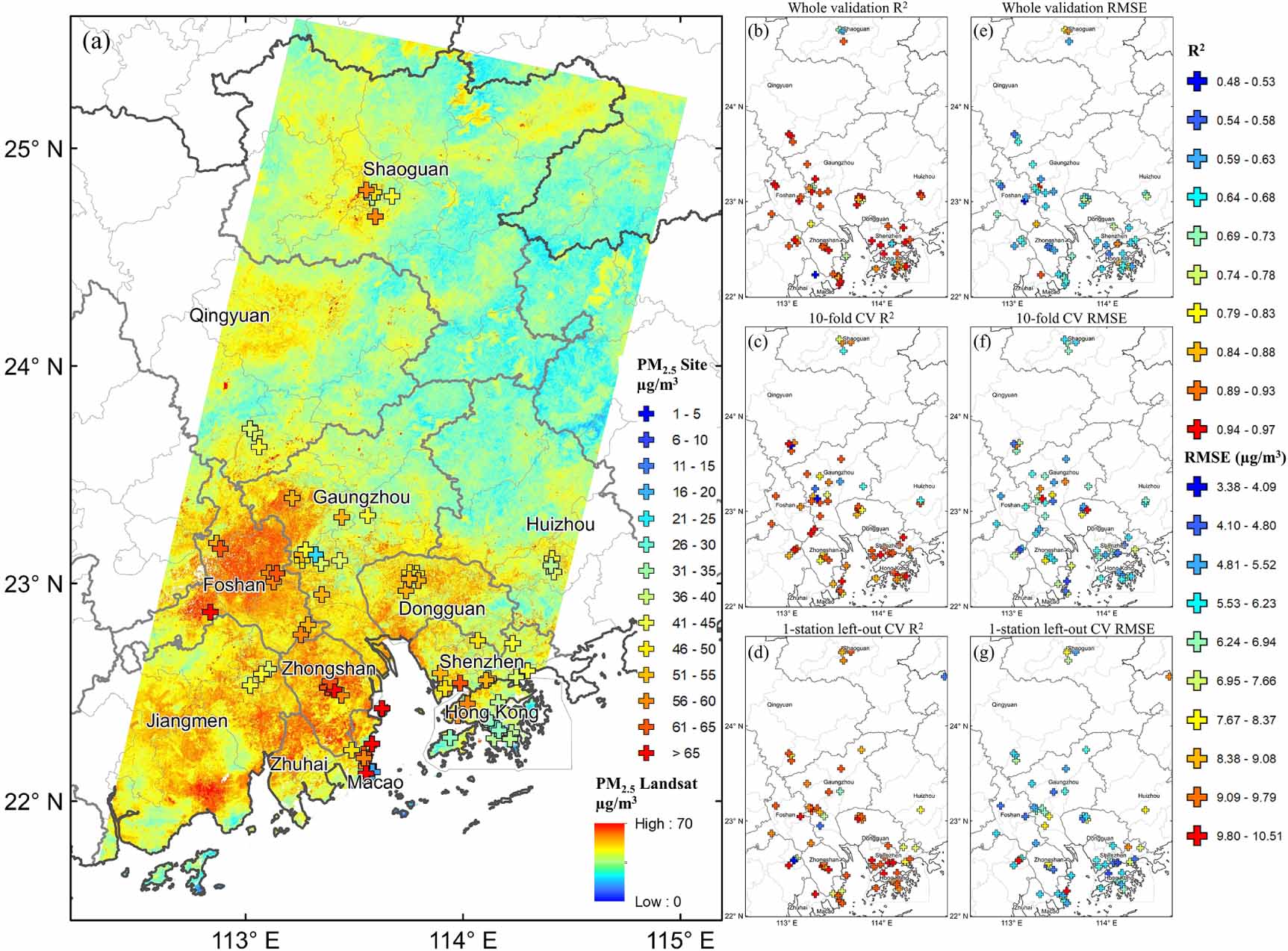
The Landsat-8 OLI/TIRS C1 Level-1 data were used for the AOD retrieval. Detailed parameters can be found in table S1. Three granules with a similar scene time inside the PRD region were chosen (figure 1). Any day during 2014–2022 with cloud coverage less than 30% in either of the first two Landsat-8 OLI granules (marked in blue and pink) were selected. As a result, 226 Landsat-8 data in the total of 77 d were selected.
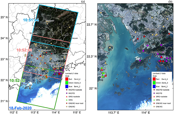
Figure 1. (a) Study area with Landsat-8 data and PM2.5 ground stations (b) a zoomed map to show the dense PM2.5 sites in Macao and Hong Kong. Reprinted from the National Geographic Information Resources Directory Service System. (www.webmap.cn).
Download figure:
Standard image High-resolution imageAuxiliary data related to the AOD-PM2.5 relationship model used in this study consisted of the 30 m Shuttle Radar Topography Mission 1 arc-second global elevation data, the 30 m Global land cover dataset (Globelland30) (Chen and Chen 2018), and the yearly 100 m WorldPop population distribution data (hub.worldpop.org). The meteorological data were obtained from ECMWF (https://cds.climate.copernicus.eu/) ERA5-Land hourly data with the continuous real-time gridded data measured at spatial resolutions of 0.1°, including 10 m U-component of wind (m s−1), 10 m V-component of wind (m s−1), 2 m temperature (K), surface net solar radiation (J m−2), surface pressure (Pa), leaf area index with low vegetation (m2 m−2), leaf area index with high vegetation (m2 m−2), total evaporation (m.w.e meter of water equivalent) and total precipitation (m). The wind velocity (m s−1) and direction (°) were also calculated using 10 m U and V components. The relative humidity (%) was calculated using the 2 m dewpoint temperature (K), 2 m temperature, and surface pressure data. To improve the accuracy and spatial resolution, we also combined the ECMWF grided data with hourly meteorological in-situ measurements from NOAA Integrated Surface Data lite data set (www.ncei.noaa.gov/pub/data/noaa/isd-lite/) including temperate, surface pressure, wind speed, and wind direction.
For AOD results validation, we used two sites with level 2.0 AOD AERONET data (Giles et al 2019) at 440 nm with a network of ground-based Sun photometers within ±1 h of the Landsat-8 scenes acquisition time. PM2.5 results validation used PM2.5 data at 62 stations obtained from China National Environmental Monitoring Centre (CNEMC) (http://106.37.208.233:20035/) measured by ambient air quality continuous automated monitoring system, at six stations from Macao Meteorological and Geophysical Bureau (SMG) (www.smg.gov.mo) measured with tapered element oscillating microbalance or beta ray attenuation method, and at 16 stations from Hong Kong Environmental Protection Department (HKEPD) (www.aqhi.gov.hk/) collected by continuous ambient air monitor.
It is noted that the PM2.5 results validation included the roadside PM2.5 measurements collected at two SMG roadside stations, nine near-road CNEMC stations (⩽10 m away from the edge of roads) and three HKEPD roadside stations.
The digital map obtained from Open Street Map (OSM) (www.openstreetmap.org) was utilized to abstract the PM2.5 concentration through 15 types of roads, including cycleway, footway, living road, motorway, path, pedestrian road, primary road, residential road, secondary road, service road, steps, tertiary, track road, trunk road, and unclassified road. The definitions and examples for each road type are provided in table S2.
2.2. AOD retrieval algorithm
The AOD retrieval algorithm was developed by combining the DT method with the SVM model. We first applied the DT method on vegetation and water surface, and then used the surrounding AOD results in the urban area as training data to estimate the AOD values over urban land surfaces. SVM model was chosen because of its ability to explain nonlinear relationships with small samples.
The detailed processes included pre-processing, classification, and modelling. Firstly, the raw Landsat 8 data were pre-processed using radiation calibration, atmospheric correction and cloud detection algorithms (Qiu et al 2019). Secondly, we removed the areas covered by clouds and the coastal areas, and classified the remaining data into dense vegetation, water, and complex urban surface. The surface reflectance of vegetation and water surfaces was dominated by groups of endmembers corresponding to water, soil, and vegetation. The DT method was thus applied to these two types of surfaces for the AOD estimation.
Regarding the AOD retrieving algorithm for urban surfaces, machine learning was chosen because the urban land cover is complex and always contains bright areas, which could highly affect the accuracy of the DT method. To avoid such uncertainty, we used the average AOD of vegetation and water surfaces near the urban area within 3 × 3 pixels as the training data to fit the relationship between AOD and Landsat-8 reflectance. Deep blue (0.440 µm), green (0.560 µm), near-infrared (0.865 µm), and short-wave infrared (2.200 µm) band were used as parameters. Pixels with more than three vegetation and water pixels nearby were chosen as samples to estimate the relationship within urban surface areas using the SVM model. To choose representative samples and improve algorithm efficiency over Landsat-8 urban areas with a complex morphology structure, we used simple linear iterative clustering (SLIC) super-pixels (Achanta et al 2012) to efficiently group similar pixels to include as many types of urban areas as possible. 1000 SLIC Super-pixels were first built (figure S4), whereas 10 sample pixels were chosen within each Super-pixel. The model was built and validated by 10-fold cross-validation (10-fold CV) to avoid the over-fitting problem and then applied to all urban area pixels. More detailed information can be found in the Supporting Information (SI).
2.3. PM2.5-AOD relationship model
The RF model was applied to analyse the AOD-PM2.5 relationship because it can predict both continuous and categorical features and determine the relative importance of each feature. All the Landsat-8 AOD results from 2014 to 2022 were used in this model. Overall, AOD results in 226 Landsat-8 images on 77 d in the study period were retrieved and used in our roadside PM2.5 pollution analyses. For each day, two to three Landsat-8 granules were used, and the average AOD was calculated for the Landsat-8 scene-overlapping areas. Moreover, to further improve the model performance, auxiliary data related to the AOD-PM2.5 relationship were also included in the model, such as land-use data, population data, and meteorological data. As shown in figure S5, all the parameters were analysed based on the relative importance of PM2.5 and the collinear relationship between one another, according to the p-value of the F-test and the variance inflation factor method, respectively.
For PM2.5 results validation, our retrieval PM2.5 concentration was compared to ground-level measurements at 84 sites. Cubic spline interpolation was used with the coordinates of stations to match the interpolated values of our results. To avoid the common over-fitting problem, three kinds of cross-validation were conducted and cross-compared: (1) the 10-fold CV, in which 90% of the sample were randomly selected as training data, and the remaining 10% data were used for validation. This validation was repeated 10 times; (2) the cross-validation with a single station withheld (1-station left-out CV), in which one of the stations was taken turns to be withheld when building another model, and the modelled PM2.5 results were then compared with the data of the withheld station; and (3) validation by the whole data set (whole validation), in which the model built based on all the PM2.5 site data was applied to the Landsat-8 AOD retrievals to get the PM2.5 ground level estimation.
3. Results and discussion
3.1. Results validation
Figure 2(a) shows the PM2.5 of 10-18-2015 as an example, whereas the complete results during 2014–2022 are shown in figure S8. Before analysing roadside PM2.5, we first intensively validated for our developed PM2.5 retrieval algorithms in two parts: (1) AOD and (2) PM2.5.

Figure 2. (a) A sample of spatial distribution of satellite-retrieval PM2.5 concentration distribution (µg m−3) on 10-18-2015; PM2.5 R2 among each station using model based on (b) whole validation (c) 10-fold CV and (d) 1-station left-out CV, and PM2.5 RMSE (µg m−3) among each station using model based on (e) whole validation (f) 10-fold CV and (g) 1-station left-out CV. Reprinted from the National Geographic Information Resources Directory Service System. (www.webmap.cn).
Download figure:
Standard image High-resolution imageThe retrieved AOD were validated using AERONET AOD. Figure S6 (a) shows the validation of AOD against AERONET AOD within ±1 h of the Landsat-8 scenes acquisition time from two sites in Hong Kong. The overall R2 and RMSE were 0.84 and 0.15 µg m−3, respectively, indicating that our Landsat-8 AOD retrieval model was reliable. We also compared our AOD results with MODIS MAIAC AOD (R2 = 0.58; RMSE = 0.14 µg m−3), and the traditional DT method-retrieved AOD (R2 = 0.30; RMSE = 0.19 µg m−3), as shown in figure S6 (b). In addition, figure S7 compares the spatial patterns between MODIS MAIAC AOD and Landsat-8-derived AOD products on 15-10-2014 and 05-11-2016 as an example. The results indicate that both results had a similar spatial distribution; nevertheless, the Landsat-8 AOD contained more detailed spatial information.
We also compared our results with the hourly PM2.5 ground-level measurements at 84 stations in the matching time (figures 2(b)–(g)). On average, R2 and RMSE were estimated to be 0.86 and 7.72 µg m−3, respectively. On the other hand, 10-fold CV shows R2 = 0.75 and RMSE = 9.81 µg m−3, whereas 1-station left-out CV shows R2 = 0.74 and RMSE = 9.94 µg m−3 (figure 3). In addition, we compared 1 km PM2.5 product generated from MODIS MAIAC AOD products by (Wei et al 2019) (figures S9–S11). The results show R2 and RMSE to be 0.72 and 10.0 µg m−3, respectively. We also compared the range of our PM2.5 estimation in each PRD city with all the PM2.5 ground-level measurements. We selected the stationary data from 2014 to 2022 under clear sky condition with less than 30% cloud coverage and no precipitation. Figure S9 shows that the range of our PM2.5 results in all 11 PRD cities was consistent with the PM2.5 stationary data. The results above overall indicate that our results had a comparable accuracy and provided more spatial distribution details.
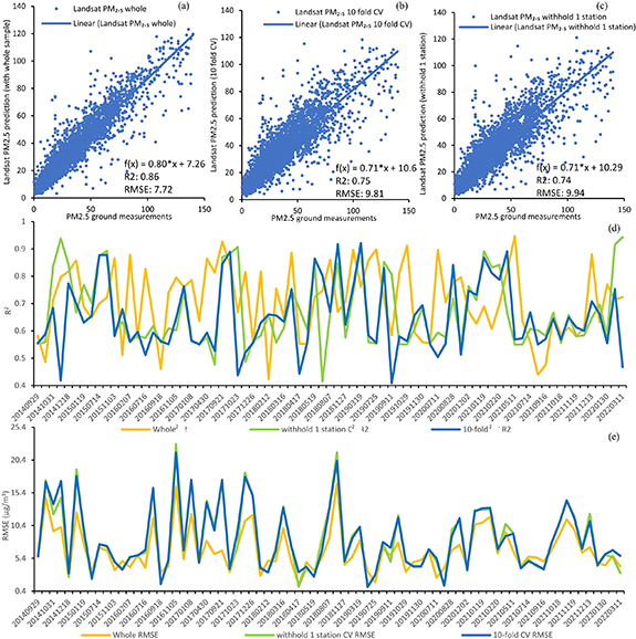
Figure 3. PM2.5 validation results with all 84 PM2.5 stations (R2 and RMSE) for (a) whole validation, (b) 1-station left-out CV, (c) 10-fold CV; the R2 (d) and RMSE (e) of the three types of validation in each day.
Download figure:
Standard image High-resolution image3.2. Roadside PM2.5 analysis
With the 30 m PM2.5 results, we analysed PM2.5 distribution in the 11 cities in PRD region at the road level. Our retrieved PM2.5 concentration was first overlaid onto OSM digital road data to extract roadside PM2.5 on 15 types of roads. The definitions and examples for each road type can be found in table S2. Figure 4 depicts the highly polluted roads in each city as a demonstration. Our results show high PM2.5 values often occurred in heavy traffic road types such as motorway, trunk, and primary roads. Within busy expressway roads, hot spots were often found in the middle part of roads due to high-speed car movement (e.g. up to 107.60 µg m−3 on Motorway in Foshan, 103.99 µg m−3 on Motorway in Zhuhai). On the contrary, within inner city roads, high PM2.5 were often located at street intersections because of congestions, acceleration, and stop-and-go activities (e.g. up to 100.09 µg m−3 on secondary road in Guangzhou, 90.71 µg m−3 on living road in Shenzhen).
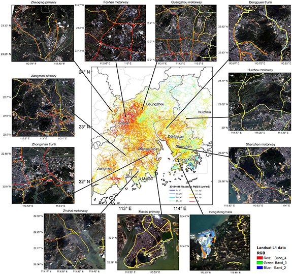
Figure 4. A sample of roadside PM2.5 concentration (µg m−3) over PRD in 10-18-2015 and of the road types in the 11 cities with the relatively high PM2.5. Reprinted from the National Geographic Information Resources Directory Service System. (www.webmap.cn).
Download figure:
Standard image High-resolution imageConsidering the distribution difference within different parts of the roads, we applied the Monte Carlo method (Garcia et al 1987) to statistically evaluate the differences in roadside air pollution between different road types, cities, and dates. In each comparison, we randomly selected 1000 000 samples, and removed any insignificant results (p-value ⩾ 0.05). Comparing to averaging, our method can analyse the difference in PM2.5 between roads on a more detailed level. The average PM2.5 concentration for each road type, cities and dates can also be found in figure S15.
Figure 5(a) shows the difference in roadside PM2.5 between each city. It notes that warmer colour in the vertical direction indicates higher PM2.5 concentration whereas cooler colour means lower values. The average PM2.5 concentration for each city and date were also provided in figure S16 in SI. Among all the cities in the PRD region, roads in traffic hub cities such as Foshan and Guangzhou were the most polluted, followed by surrounding cities such as Dongguan, Zhongshan, and Jiangmen. Meanwhile, Hong Kong's roads showed the lowest PM2.5 concentration of 31.71 µg m−3 on average, almost 29.70% higher than the average value in Foshan. Seaside cities such as Shenzhen, Zhuhai and Macao were also relatively clean, with average PM2.5 of 34.54 µg m−3, 35.60 µg m−3, and 36.48 µg m−3, respectively. We also calculated the difference in PM2.5 in each road type among each city. The difference in PM2.5 between each city tended to be more obvious on roads for motorized vehicles, such as motorway, primary road, secondary road, and trunk road, and less noticeable on roads for non-motorized vehicles and pedestrians such as cycleway, footway, and track roads. This indicates that the PM2.5 concentration level on non-motorized roads in most PRD cities were not dominated by traffic air pollution. Instead, they were likely to be dominated by background PM2.5 level.
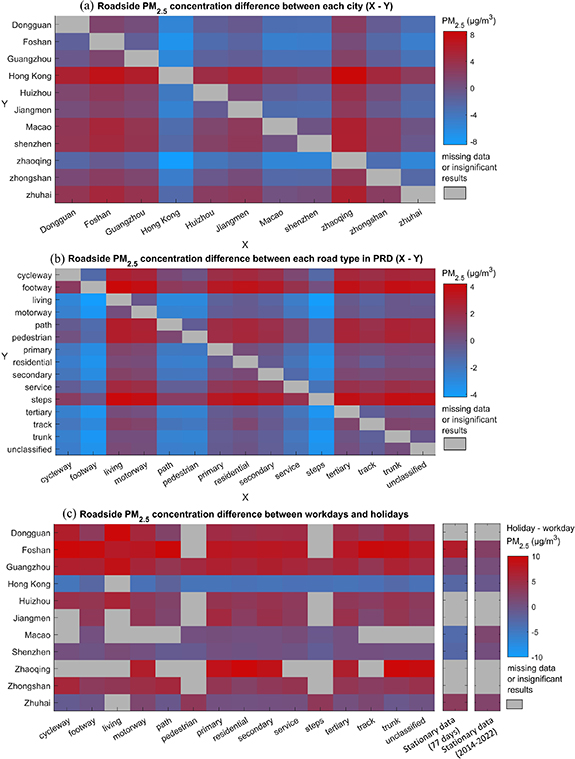
Figure 5. Roadside PM2.5 comparison (µg m−3) between (a) the PRD 11 cities; (b) 15 road types in the PRD region; (c) workdays and holidays in each road type and in each PRD city. In (c), the last two columns show the results based on the data collected at ground level stations.
Download figure:
Standard image High-resolution imageFigure 5(b) displays the differences in PM2.5 among each road type in the PRD region. In general, warmer colours on the vertical axis often appeared on road types related to motorized vehicles. Cooler colours with negative values often appeared on roads related to non-motorized vehicles and pedestrians, such as cycleway, footway, path, pedestrian, and steps. Average PM2.5 higher than 37.00 µg m−3 only occurred on motorized road types such as trunk, tertiary, motorway, primary, secondary, residential road, and living road. The highest PM2.5 was observed on the trunk roads (38.98 µg m−3 on average), whereas the lowest PM2.5 was observed in road type of steps. The PM2.5 level of trunk roads was 18% higher than that of the road type of steps, which were typically on hiking trails and more far away from main roads compared to cycleway and pedestrian roads.
We also analysed the differences in PM2.5 among road types in each city (figure S17). In most cities in the region, the highest PM2.5 appeared in primary roads, trunk, and motorways, which were usually major divided highways with 4–8 lanes. PM2.5 on these roads were 9%–22% higher than that on the cleanest non-motorized roads. The highest PM2.5 were located on motorway in Foshan (max: 107.60 µg m−3; mean: 48.03 µg m−3). In Hong Kong, tracks roads had the highest PM2.5 (max: 85.10 µg m−3; mean: 33.54 µg m−3), which were 12% higher than the average PM2.5 on step roads. Track roads were usually routes that were separated from traffic, but several hot spots (figure S18) were found in track roads contributing to high air pollution, such as the one inside the WENT (West New Territories) landfill, and the road outside of an asphalt company, which has already been convicted and fined by the government for violating the Air Pollution Control Ordinance license conditions.
Figure 5(c) depicts the differences in PM2.5 between holidays and workdays in each road type and city according to different local laws in mainland China, Hong Kong, and Macao. According to the figure, Hong Kong was the only city with higher PM2.5 concentration (1.93–4.50 µg m−3) during workdays, whereas PM2.5 level remained the same between holidays and workdays in Shenzhen, Zhuhai, and Macao. In the rest of PRD cities, PM2.5 concentration in holidays were 8%–17% higher than that in workdays. To prove our findings, we also calculated the holiday-workday differences in PM2.5 using the roadside PM2.5 measurements with the same time periods of our retrieval PM2.5 data. The roadside data measurements show comparable results with the satellite retrieved data showing larger differences in PM2.5 between holiday and workday. The holiday-workday pattern could be because tourists in Hong Kong may prefer to use the advanced public transfer system inside the city, whereas people in mainland China tended to drive between cities on holidays; the other reason could be Hong Kong cross-border trucking with mainland China on workdays was busier than on holidays. To further understand the traffic pattern, we evaluated the traffic volume data in Hong Kong and Shenzhen (figure S21). It shows that the traffic volume in Hong Kong was almost 30% higher on holidays then on workdays, whereas Shenzhen shows negligible difference in its traffic volume between holidays and workdays. This is consistent with our results. It is noted that our analysis focused on clear-sky condition, whereas traffic volume may reduce during severe weather conditions (Miao et al 2019, Akter et al 2020).
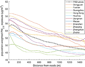
Moreover, we calculate the roadside the population-weighted PM2.5 exposure using the formula ∑(Pi * Ci )/∑Pi, where Pi is the population and Ci is the PM2.5 concentration. We analysed the population-weighted PM2.5 as a function of distance from roads starting from 0 m to 1500 m in the PRD region and in each city. This analysis only considered the roads for motorized vehicles with high PM2.5 including motorway, primary, residential, secondary, service, tertiary, track, trunk and unclassified roads. We calculated the distance between each pixel within boundary of each city and the nearest road (figure S19), and then calculated the average population-weighted PM2.5 within each 30 m distance ring from roads.
Figure 6 shows that the population-weighted PM2.5 tended to decrease with the increasing distance from roads in the whole PRD region and in each city. Among all the PRD cities, Dongguan, Foshan, Zhongshan and Jiangmen had relatively high population-weighted PM2.5 near roads. Guangzhou had a comparable level of population-weighted PM2.5 within 200 m from roads, and then the population-weighted PM2.5 declined sharply and became the second last after 1 km from roads. Similar to Guangzhou, Shenzhen and Hong Kong show the similar sharp reduction in population-weighted PM2.5 after several meters from roads. This characteristic clearly reflected the critical impacts of the traffic emissions to the air pollution near roads in the cities. On the other hand, Zhuhai had relative marginal changes along distances from roads due to its relatively less traffic. The stable level of population-weighted PM2.5 reflected the minor contribution of traffic emissions to the air quality in Zhuhai.
Figure 6. The averaged population-weighted PM2.5 (µg m−3) as a function of distance from roads starting from 0 m to 1500 m in the PRD region and in each city. The values in each distance point were averaged in a 30 m distance interval.
Download figure:
Standard image High-resolution image
Our results also show that the population-weighted PM2.5 profiles of the PRD region and most of the PRD cities (8 out of 11) had an increase within 100 m from roads. The slight increases in population-weighted PM2.5 indicate that the traffic pollution tended to accumulate within a certain distance, and there might be a heightened population-weighted PM2.5 zone near the roads. Overall, the population-weighted PM2.5 was 2%–22% higher at roadsides than at distances more than 1500 m away from roads in the PRD region.
3.3. Future research
This study provided a comprehensive analysis of roadside PM2.5 distribution and the resultant population exposure. It should be noted that evaluating the contribution of traffic-related emissions to roadside PM2.5 is critical. Future studies are recommended to conduct a source apportionment study to assess the contribution of vehicular emissions and the background PM2.5 to the roadside PM2.5 in various cities. Additionally, we plan to enhance the temporal resolution of our results by combining multiple satellite sources. These proposed improvements are anticipated to further enhance our understanding of roadside PM2.5 distribution.
4. Conclusions
This study developed Landsat-8 PM2.5 retrieval algorithms to derive PM2.5 concentration at 30 m spatial resolution over the PRD region and applied the retrieval PM2.5 results to analyse roadside air pollution in the PRD cities. The Landsat-8 retrieval AOD results show a better relationship with AERONET AODs compared to the traditional DT method and MODIS 1 km MAIAC AOD products. In addition, our PM2.5 estimation shows a good relationship with PM2.5 ground-level measurements including those at roadside stations. Our roadside pollution analyses show that the roadside PM2.5 in Dongguan, Foshan, Guangzhou, Zhaoqing and Zhongshan were relatively higher, whereas that in Hong Kong was relatively lower. The high roadside PM2.5 typically occurred at roads for motorized vehicles, such as, motorway, trunk, primary roads, secondary roads, and tertiary roads. Furthermore, roadside PM2.5 was also higher in holidays than workdays in the PRD region except for Hong Kong which shows an opposite result. This was consistent with traffic volume data. Additionally, we found that the population-weighted PM2.5 decreased with the increasing distances from roads in the whole PRD area, and serious roadside PM2.5 pollution was clearly shown in some cities. The decline rate appeared to reduce and to even stabilize in the areas more than 1 km away from roads, suggesting that areas far away from roads may be less influenced by traffic emissions. This study underscored the adverse roadside PM2.5 pollution in the PRD region.
Acknowledgments
The authors would like to thank for the following grants for their supports on this research: Start-up Grant from NTU (SUG: 021384-00001) and Ministry of Education of Singapore (MOE SUG: 021452-00001), MOE AcRF Tier 1 from Ministry of Education of Singapore (RG126/21: 021591-00001), EOS FY2022 funding (EOS MOE RCE FY 2022: 021943-0001) from Earth Observatory of Singapore at NTU and Dr Stanley Ho Medical Development Foundation (Grant No. 8305509).
Data availability statement
The data cannot be made publicly available upon publication because they are not available in a format that is sufficiently accessible or reusable by other researchers. The data that support the findings of this study are available upon reasonable request from the authors.
Supplementary data (10. MB PDF)