GPS Solutions ( IF 4.9 ) Pub Date : 2023-12-01 , DOI: 10.1007/s10291-023-01578-3 Zhitao Wang , Shuli Song , Wenhai Jiao , Wei Wei , Weili Zhou , Guoqiang Jiao , Jialong Liu
|
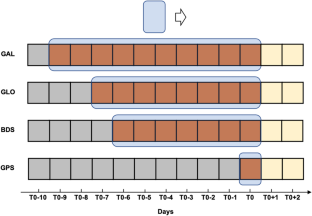
Evaluation for Global Navigation Satellite System (GNSS) Position Dilution Of Precision (PDOP) is generally based on a simulated global grid with a specific Temporal–Spatial (T–S) resolution. However, the lack of a unified evaluation standard regarding the grid model, T–S resolution and evaluation period leads to inaccurate PDOP evaluation results and unreasonable comparisons among multi-GNSS. We propose the Equal-Arc-Length Grid (GRID_EAL) for PDOP evaluation, which can avoid the bias caused by uneven point distribution present in the commonly used Equal-Interval of Longitude and Latitude Grid (GRID_ELL) and provide more accurate results. Based on GRID_EAL, we thoroughly analyze the varying characteristics and convergence of PDOP metrics with different T–S resolutions. The results indicate that the optimal T–S resolution is 300 s and 3 degrees, reducing time and memory costs by 90% compared to the T–S resolution of 30 s and 3 degrees, while ensuring evaluation accuracy. Moreover, to ensure the representativity of PDOP evaluation for each system, a sliding window method is developed based on the Constellation Ground Track Repeat Period, which enables continuous daily comparisons among multi-GNSS. The proposed method satisfies the requirements for the unified evaluation standard set by the International Committee on Global Navigation Satellite Systems, International GNSS Monitoring and Assessment, and benefits PDOP evaluation and comparison for multi-GNSS.
中文翻译:
优化网格模型和时空分辨率的多GNSS统一PDOP评估方法
全球导航卫星系统 (GNSS) 位置精度因子 (PDOP) 的评估通常基于具有特定时空 (T-S) 分辨率的模拟全球网格。然而,由于网格模型、T-S分辨率和评估周期缺乏统一的评估标准,导致PDOP评估结果不准确,多GNSS之间的比较不合理。我们提出等弧长网格(GRID_EAL)进行PDOP评估,它可以避免常用的经纬度等距网格(GRID_ELL)中存在的点分布不均匀造成的偏差,并提供更准确的结果。基于GRID_EAL,我们深入分析了不同T-S分辨率下PDOP指标的变化特征和收敛性。结果表明,最佳的T-S分辨率为300 s和3度,与30 s和3度的T-S分辨率相比,减少了90%的时间和内存成本,同时保证了评估精度。此外,为了保证各系统PDOP评估的代表性,基于星座地面轨迹重复周期开发了滑动窗口方法,可以实现多GNSS之间的连续每日比较。该方法满足国际全球导航卫星系统委员会、国际GNSS监测与评估统一评估标准的要求,有利于多GNSS的PDOP评估和比较。


 京公网安备 11010802027423号