Izvestiya, Atmospheric and Oceanic Physics ( IF 0.7 ) Pub Date : 2024-01-31 , DOI: 10.1134/s0001433823090098 J. N. Ivanova , I. O. Nafigin
|
Abstract
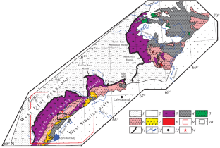
In the course of this study, an approach is developed focused on identifying probabilistic zones of increased fracturing (areas with a high density of lineaments), considered a predictive sign for the localization of ore mineralization in the central part of the Maloural’skaya zone (the Polar Urals). This area is promising for the detection of polymetallic-type ore occurrences (Fe, Cu, Cu-Zn, and Au-Cu). Predictive schemes for the distribution of highly permeable rock zones are constructed and promising areas for polymetallic mineralization are identified based on this approach, accounting for the geological information, the distribution of mineral resources, remote sensing data and the results of their processing, and the lineament density schemes. The remote sensing data processing is based on the identification of structures by manual and automatic methods and their integration based on fuzzy logic. Morphostructural maps obtained from the Landsat-8 spacecraft data show that ore occurrences of polymetallic specialization known in the area are located along the perimeter of a large morphostructure of the first order, as well as near radial structures up to 20 km in length in the NE and (less often) in the NW direction. As a result of a comparison of remote sensing data with the geological map of the study area and known ore occurrences, six promising zones are identified. The contoured areas show spatial consistency with several known polymetallic ore occurrences localized in the study area.
中文翻译:
利用 Landsat-8 卫星数据以 Maloural'skaya 地带(极地乌拉尔)中部为例,预测北部地区矿石成矿情况
摘要
在这项研究过程中,开发了一种方法,重点是确定破裂增加的概率区域(线状密度高的区域),被认为是 Maloural'skaya 区域中部矿石矿化定位的预测标志。极地乌拉尔)。该区域有望检测多金属型矿石(铁、铜、铜-锌和金-铜)。基于该方法,综合考虑地质信息、矿产资源分布、遥感数据及其处理结果以及地貌特征,构建高渗透岩石区分布预测方案,并识别有前景的多金属矿化区。密度方案。遥感数据处理基于手动和自动方法的结构识别及其基于模糊逻辑的集成。从 Landsat-8 航天器数据获得的形态结构图显示,该地区已知的多金属特化矿点位于大型一级形态结构的周边,以及东北部长度长达 20 公里的近径向结构以及(较少)在西北方向。通过将遥感数据与研究区域的地质图和已知矿点进行比较,确定了六个有前景的区域。轮廓区域显示出与研究区域内的几个已知多金属矿产地的空间一致性。


 京公网安备 11010802027423号