Izvestiya, Atmospheric and Oceanic Physics ( IF 0.7 ) Pub Date : 2024-02-20 , DOI: 10.1134/s0001433823120125 Yu. N. Ivanova , I. O. Nafigin
|
Abstract
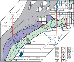
For the first time, we apply a new approach to processing earth remote sensing data obtained by the Landsat-8 spacecraft to the central part of the Maloyralskaya zone, the Polar Urals. It consists of integrating metasomatic alteration distribution maps and lineament density patterns that were created based on the results of statistical processing of remote sensing data and the Shuttle Radar Topography Mission (SRTM) digital elevation model. This study is aimed at identifying morphological features and patterns and features of the deep structure and at identifying areas promising for the gold-polymetallic type of mineralization in the studied area. As a result of the study, it is established that areas promising for the gold–polymetallic type of mineralization in the central part of the Maloyralskaya zone are localized along transregional fault zones that intersect favorable horizons and structures and control ore mineralization and within large morphostructures complicated by radial faults of the first-order NE and NW direction with a length of up to 30 km, as well as areas with increased indices of iron oxides (II and III) and, less often, hydroxide (Al–OH and Mg–OH) and carbonate-containing minerals.
中文翻译:
使用 Landsat-8 数据集和航天飞机雷达地形任务数字地形模型对 Malouralskaya 地带中部(极地乌拉尔地区)金多金属矿化预测
摘要
我们首次采用一种新方法来处理由 Landsat-8 航天器获得的位于 Maloyralskaya 区域中部(极地乌拉尔)的地球遥感数据。它包括根据遥感数据统计处理结果和航天飞机雷达地形任务(SRTM)数字高程模型创建的交代蚀变分布图和线状密度模式的集成。本研究旨在确定深部构造的形态特征、模式和特征,并确定研究区域内有希望形成金多金属类型矿化的区域。研究结果表明,Maloyralskaya 地带中部有希望出现金多金属类型矿化的区域位于跨区域断层带,该断层带与有利层位和构造相交并控制矿石成矿,并且位于复杂的大型地貌结构内。由长度长达 30 公里的一级 NE 和 NW 方向的径向断层以及铁氧化物(II 和 III)指数增加的区域以及较少见的氢氧化物(Al-OH 和 Mg-OH)指数增加的区域)和含碳酸盐矿物。


 京公网安备 11010802027423号