Theoretical and Applied Climatology ( IF 3.4 ) Pub Date : 2024-03-08 , DOI: 10.1007/s00704-024-04918-6 Koussa Miloud
|
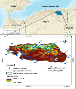
In this work, annual precipitation measurements and averages of the maximum temperature of the warmest month and the average of the minimum temperature of the coldest month were used; these data were are extracted from the period 1981–2022 in the Beni Haroun watershed located in eastern Algeria, and were spatially interpolated using deterministic and geostatistical methodologies in a GIS environment. In particular, a comparison was made between inverse distance weighting (IDW) and ordinary kriging (OK) to evaluate the most appropriate technique for reproducing the actual surface. Then, the spatial fluctuation in aridity in the watershed was evaluated using the Emberger index, which is based on annual precipitation measurement data and the averages of the maximum temperature of the warmest month and the averages of the minimum temperature of the coldest month. It is clear that geostatistical approaches provide a more accurate estimations than IDW methods. Specifically, OK was identified as the optimal prediction technique for Emberger quotient data. Furthermore, the spatial distribution of the Emberger quotient showed that the northwestern parts of the basin presented the highest aridity values.
中文翻译:
阿尔及利亚东部贝尼哈伦流域的干旱绘图
在这项工作中,使用了年降水量测量以及最热月最高气温的平均值和最冷月最低气温的平均值;这些数据是从 1981 年至 2022 年期间位于阿尔及利亚东部的贝尼哈伦流域提取的,并在 GIS 环境中使用确定性和地统计方法进行空间插值。特别是,对反距离加权 (IDW) 和普通克里金法 (OK) 进行了比较,以评估再现实际表面的最合适技术。然后,利用年降水量测量数据以及最暖月最高气温和最冷月最低气温平均值的Emberger指数评价流域干旱度的空间波动。很明显,地统计方法提供了比 IDW 方法更准确的估计。具体来说,OK 被确定为 Emberger 商数据的最佳预测技术。此外,Emberger商的空间分布表明,流域西北部地区的干旱度最高。


 京公网安备 11010802027423号